Chemaudin
| Chemaudin | ||
|---|---|---|
|
|
||
| local community | Chemaudin and Vaux | |
| region | Bourgogne-Franche-Comté | |
| Department | Doubs | |
| Arrondissement | Besançon | |
| Coordinates | 47 ° 13 ' N , 5 ° 54' E | |
| Post Code | 25320 | |
| Former INSEE code | 25147 | |
| Incorporation | January 1, 2017 | |
| Website | www.chemaudin.fr | |
Chemaudin was a community with last 1,501 inhabitants (as of 1 January 2013) in the French department of Doubs in the region Bourgogne Franche-Comté . Chemaudin is part of the municipality of Chemaudin et Vaux .
geography
Chemaudin is located at 274 m , about ten kilometers west of the city of Besançon (as the crow flies). The village extends on the edge of a hill in the gently undulating landscape between the rivers of Doubs in the south and Ognon (in the north).
The area of the 7.30 km² former municipal area comprised a section north of the Doubstal. The area was delimited by various traffic routes: in the north by the A36 motorway, in the east by its feeder D67 and in the south by the main road N73, which leads from Besançon to Dole . The main part of the area was taken up by a plain, which consists partly of arable land and meadow, in the south mainly of forest ( Bois d'Essart-Dédier ). To the northwest the community area extended into the gently undulating landscape between Doubs and Ognon. On the watershed between these two rivers, the highest point of Chemaudin was reached at 310 m. The northernmost section is drained by the Chevrey north to the Doubs.
Neighboring communities of Chemaudin were Vaux-les-Prés in the north, Franois in the east, Grandfontaine in the south and Dannemarie-sur-Crète in the west.
history
Various finds indicate that the former municipality of Chemaudin was already settled during the Bronze Age. The place is first mentioned in the 12th century under the name Chemadein . Over time, the spelling changed via Chemadin (13th century), Chimadain and Chamadain (14th century), Cheauldain (15th century) and Chimaudin (1664) to today's place name, which has been documented since the 18th century.
In the Middle Ages, Chemaudin was part of the Saint-Étienne cathedral chapter in Besançon. In addition, the lords of Montferrand had rich property in the village. Chemaudin was badly affected during the Thirty Years War . Together with Franche-Comté , the village finally came to France with the Peace of Nijmegen in 1678.
With the creation of an industrial zone in 1975, the development to the suburb of Besançon began. Since January 1, 2001, Chemaudin and 57 other municipalities have been part of the Communauté d'agglomération du Grand Besançon .
On January 1, 2017, the municipality of Chemaudin merged with Vaux-les-Prés to form the new municipality of Chemaudin et Vaux.
Attractions
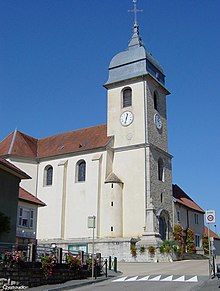
The Saint-Alban church was consecrated in 1737. It has a porch with a church tower that is unique for the region. Inside there is an altar retable (1750) designed by Nicolas Nicole. Various farmhouses in the traditional Franche-Comté style from the 18th and 19th centuries have been preserved in the old town center.
Population of the former parish
| Population development | |
|---|---|
| year | Residents |
| 1962 | 409 |
| 1968 | 487 |
| 1975 | 600 |
| 1982 | 702 |
| 1990 | 941 |
| 1999 | 1,222 |
| 2005 | 1,430 |
| 2013 | 1,501 |
Chemaudin was one of the smaller municipalities in the Doubs department with its most recent population of 1,501 (as of January 1, 2013). After the population in the first half of the 20th century had always been in the range between 320 and 380 people, a striking population growth has been recorded since the beginning of the 1960s. After that, the population has more than tripled.
Economy and Infrastructure
The village, which was dominated by agriculture (arable farming, fruit growing and cattle breeding) and forestry until well into the 20th century, has developed into an industrial and commercial location since the mid-1970s thanks to the good traffic situation. Around 25 companies have settled in the industrial and commercial zones along the main roads. The important sectors include the manufacture of gas pressure springs and seals, the transport industry, a printing company and an Ecospace logistics center. In the meantime, the village has also turned into a residential community. Many workers are therefore commuters who go to work in the Besançon agglomeration.
The village is very well developed in terms of traffic. It is located near the main D67 road from Besançon to Gray . The nearest connection to the A36 motorway , which crosses the municipality, is about three kilometers away. Further road connections exist with Dannemarie-sur-Crète, Villers-Buzon and Franois.
partnership
Since August 1997, Chemaudin has maintained a partnership with the municipality of Molschleben in Thuringia .

