
Molschleben
| coat of arms | Germany map | |
|---|---|---|

|
Coordinates: 51 ° 0 ' N , 10 ° 47' E |
|
| Basic data | ||
| State : | Thuringia | |
| County : | Gotha | |
| Management Community : | Nesseaue | |
| Height : | 290 m above sea level NHN | |
| Area : | 15.24 km 2 | |
| Residents: | 1002 (Dec. 31, 2019) | |
| Population density : | 66 inhabitants per km 2 | |
| Postal code : | 99869 | |
| Area code : | 036258 | |
| License plate : | GTH | |
| Community key : | 16 0 67 047 | |
| Address of the municipal administration: |
Dr.-Külz-Str. 4 99869 Friemar |
|
| Website : | ||
| Mayor : | Marcel Struppert (non-party) | |
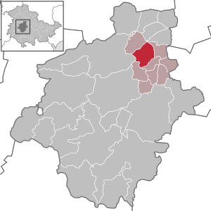
| Location of the community of Molschleben in the district of Gotha | ||
  |
||


Molschleben is a municipality in the administrative community of Nesseaue in the Thuringian district of Gotha .
geography
Molschleben is located on the southwest slope of the Fahner Höhe . The closest villages and communities are Eschenbergen (N), Bienstädt (NO), Tröchtelborn (SO), Friemar (S) and Bufleben (W). The surrounding land is used exclusively for agriculture. The Nesse flows along the southwestern edge of the village . In the north there is the Attichbach, which comes down from the Fahner Höhe and flows over the Kelchbrunnsgraben at the sports field into the Nesse. The highest point of the municipality is in the Fahner Höhe near the "Breiten Holz" and measures around 402 m above sea level. NN. The lowest point of the district is where the Nesse leaves the municipality, at a height of 274 m above sea level. NN. The Österbrunnen rises on the eastern edge of the village , and after a few meters it directs its water into a brook coming from the Fahner Höhe.
history
In the Younger Stone Age (11,500 to 4,500 years ago) the Molschleber Flur was a settlement area, as archaeological finds prove. Magolfeslebo was the name of the place in the first documentary mention of the inventory of the monastery initiated by the first Archbishop of Mainz Lullus and first abbot of the Hersfeld Abbey (710–786). In the absence of an exact date, the year of Lullus's death was set as the year of first manifestation for Molschleben, as was the case for many other locations in the directory. In 2011 the place celebrated its 1225th anniversary.
Around 1000 knights of Molschleben were mentioned who wore two upright scissors, so-called sheep scissors, in their coat of arms . From the 13th to the 15th century, the place belonged to the wealthy noblemen of Malsleiben . Other spellings of the place were Molsleben , Masleibin and Molsleiben . In 1438 the family died out with Heinrich and Hans von Molschleben.
A manor, also known as the Edelhof , was then owned by the Lords of Witzleben in the village. It was at the west exit of the village. Friedrich and Titzel von Witzleben were first mentioned in Molschleben in 1351. The descendants of this line, most recently Friedrich Jobst von Witzleben, maintained the manor until 1731. Alexander von Witzleben, imperial-royal chamberlain and chief forest master in Gotha, sold the manor on June 7, 1737 with all his dishes and goods (without the hunting rights ) for 25,000 Meissen gulden to 22 residents of Molschleben. Then the new owners tore down the manor and divided the lands among themselves. The mayor Christian Büchner was named in 1739 as a joint fiefdom holder of the "estate". The community acquired the right to run sheep farms (justice of the sheep drift), as well as the right to brew beer ( brewing justice ) and to serve beer ( bar justice ) from the Duke in Gotha for 1,300 guilders. Molschleben was therefore a sizable princely Gothic village as early as the 18th century .
The Thirty Years' War brought great hardship in Molschleben and reduced the population by more than two thirds. The last plague in Erfurt in 1683, which killed more than half of the population there, also reached Molschleben. In September 1757 during the Seven Years' War (1756-1763), the French troops withdrew under the Prince of Soubise and the Reichsexekution army under the Prince of Saxony-Hildburghausen against the Prussian forces under Frederick II. - the Weimar court in Gamstädt housed the King - through the region and brought great suffering to the people. After the victory of the Prussians over the French on November 5, 1757 in the Battle of Roßbach , the remaining French troops were on a chaotic way back to France and again demanded a lot from the population. In two major fires in 1764 and 1778, the village was largely destroyed twice in quick succession. With the help of the residents from the neighboring towns, 200 houses could be rebuilt.
Population development
The figures reflect the status on December 31 of each year
| 1618 | 1638 | 1780 | 1816 | 1830 | 1871 | 1939 | 1950 | 1971 | 1990 | 1995 | 2000 | 2005 | 2010 | 2015 |
|---|---|---|---|---|---|---|---|---|---|---|---|---|---|---|
| 1144 | 466 | 616 | 720 | 826 | 916 | 1096 | 1602 | 1353 | 1132 | 1125 | 1156 | 1153 | 1112 | 1045 |
economy
Agriculture and cattle breeding were the most important branches of business in the past. In addition to grain, flax and woad were also grown. The listed “Waidhof” on Gothaer Strasse is a reminder of this. Today the economic offer has expanded to include traders, craftsmen and traders.
Culture
societies
Mainly three clubs, the fire brigade club Molschleben eV, sports club "TSV 90 Molschleben" and the "Heimatverein Molschleben e. V. "are active here.
schools
School lessons were given in Molschleben since 1570. In 1657 the community built a second school building. Under the government of the educated and progressive Duke Ernst the Pious (1640–1674), compulsory schooling was introduced in the Duchy, thereby improving the quality of teaching. The prince sponsored artists, scientists and educators. During the great fire in 1764, both Molschleben schools were destroyed by flames. The upper school was rebuilt a year later, along with the barn, woodshed and stable, followed by the new construction of the lower school. After a new school building had been built on Lindenplatz in 1882, the lower school was now used as living space for teachers, as it was no longer needed as a teaching facility. The cartographer Johann Christoph Baer , who went to school in Molschleben, gave him a sundial in 1838 , which can still be seen on the building today.
The number of teachers rose to four by 1930. In the last years of the Second World War , lessons could only be irregular, as most of the teachers were drafted as soldiers. The upper school building (by the church) was used as accommodation for expelled Germans from the eastern regions . Lessons were given in only two classrooms in the school on Lindenplatz, as a makeshift also in the old bowling alley on the Schenksplatz and in two rooms of the community tavern. From 1950/1951 teaching was returned to the upper school, which was given new toilet facilities and washrooms between 1984 and 1985. In 1965 a well was bored in the school yard of the Lindenplatz school.
On February 28, 1977, classes began in the new school on Friemarer Strasse, which can teach ten school classes. In 1991 the school became a state school . Today she is visited by children from Molschleben, Friemar, Eschenbergen, Tröchtelborn, Bienstädt and Zimmersupra. Now that there were no more lessons in the upper school, the classrooms were expanded in 1977 for various local institutions. The post office, the library and the service combine (DLK) moved into the building that now serves as a residential building.
Attractions
Village church of St. Peter and Paul

One of the local attractions is the Protestant church of St. Peter and Paul. Today's church stands in the same place as its predecessor from the 8th or 9th century, which was demolished at the end of the 15th century due to dilapidation. The current late Gothic church was built in several construction phases. In 1500 the choir in the east with its Gothic windows was completed, which is confirmed by a relief stone on the southeast corner. The text reads: Anno dm MCCCCC copletue noc opus (This work was completed in the year of the Lord 1500).
The church was expanded to the west in 1528 and 1552. This can be seen from the different roof heights. The extensions on the north side are of later origin. The church is built in an east-west direction and has the dimensions 28.8 m by 8.3 m. In 1552 the 37 m high church tower was built on the north side and bears this carved year in the upper area of the tower. The thick walls stand on a floor area of 4.5 m by 4.3 m. The ground floor houses the sacristy with a cross-vaulted ceiling . The entire upper part of the tower is octagonal and slated; it dates from the 18th century. A neo-classical relief stone above the southern entrance door with the inscription MFHJ 1726 indicates the manufacture of the door and a total repair of the church. This was due because the construction got into threatening imbalances over the years. On the occasion of the renovation, the weather vane was gilded. The tower and bells are owned by the municipality. The construction is said to have been financed by the community. Repairs to the building were carried out again in 1828.
Some well-preserved old tombstones are on the south wall of the church. The church in Molschleben has a Gothic winged altar that consists of three panels.
Before the Reformation , Molschleben belonged to the diocese of Mainz and, according to a register from 1506, had the large parishes of Burgtonna , Ballstädt and Bufleben and the medium-sized parishes of Eschenbergen , Tröchtelborn , Zimmersupra , Friemar , Aschara , Westhausen , Pfullendorf , Hausen , Bienstädt and Töttelstädt as the dean's seat . The church book, kept since 1628, contains, as usual, births, baptisms, weddings and deaths. The old cemetery around the church was used until 1949.
Waidmühle
In the middle of the Schenksplatz, diagonally across from the community tavern, there is a rebuilt wood mill with an original millstone that was found on a garden plot in Gothaer Straße. In 1894, Hermann Gebhardt reported in his book From the history of the village of Molschleben about three wood mills that once stood north and south of the village. The necessary water was probably supplied by the Nesse and a small stream north of the village. The building in Gothaer Straße 3, built by Peter Anton Ulrich Piutti as a woad factory in 1793, still reminds of the lively and lucrative woad trade.
Inscription stone from 1542


On the wall of the house at Gierstädter Straße 2 there is an inscription stone from 1542. It bears the inscription "HF" for Hans Friedrich , the then reigning elector and "VDMIE" for Verbum dei manet in eternum ("The word of God remains in eternity"). Below on the left is the coat of arms of the Wettins and on the right that of the Meißner .
The "Neuenthor" ("Fahnerthor") stood here until around 1840, one of five gates in the mighty city wall. The inscription stone could have been placed above the gate. The other gates were the "Gothaer Thor" on the Badeplan, the "Lerchenthor" at the exit towards Friemar, the "Hirtenthor" at the southeast exit of the village (after which the settlement there is still named today) and the "Riedthor", for example at the end of Riedsgasse today's Schillerstrasse. In the course of amalgamation of the property in 1874 and 1875, the remains of the city wall and the ditches in front of it on the east, west and north sides of the village were removed. When the road from Gotha to Gierstädt was rebuilt, with construction beginning in 1817, the Neuenthor was removed. After the gate was demolished, there was only one barrier on the street next to a residential building in which the toll collection point was operated; the signpost on the left symbolizes it. The income did not make the place rich, but was enough to maintain the road. If you now go around the corner to the left and walk towards the transverse residential building, you can see an old inscription on a lintel in the corner, which dates from the time when the French were in the village.
Sons and daughters of the community / personalities who have worked on site
- Johann Heinrich Callenberg (1694–1760), orientalist, publicist and theologian
- Karl Friedrich Heinrich (1774–1838), classical philologist
- Hermann Gebhardt (1824–1899), pastor of the town and author of various writings
- Hannalore Demokratie (* 1939), author of Thuringian history
Individual evidence
- ^ Population of the municipalities from the Thuringian State Office for Statistics ( help on this ).
- ↑ VG Nesseaue website ( Memento of the original from October 18, 2016 in the Internet Archive ) Info: The archive link was inserted automatically and has not yet been checked. Please check the original and archive link according to the instructions and then remove this notice.
- ↑ a b c d e f g h On the nature and history of the Fahner Höhe Ed .: NABU-Landesverband eV, Kreisverband Gotha eV: 25-27
- ↑ a b Information board Gierstädter Straße 2
- ↑ a b c d Thuringian State Office for Statistics
- ^ Molschleben on the website of the church district Gotha, accessed on August 20, 2015.
- ↑ Information board on the inscription stone
Web links
Bad Tabarz | Bienstädt | Dachwig | Döllstädt | Three of a kind | Emleben | Eschenbergen | Friedrichroda | Friemar | Georgenthal | Gierstädt | Gotha | Großfahner | Manor | Earpiece | Luisenthal | Molschleben | Nesse-Apfelstädt | Nessetal | Emergency life | Ohrdruf | Horse life | Schwabhausen | Sonneborn | Tambach-Dietharz | Tonna | Tröchtelborn | Tüttleben | Waltershausen | Room supra