
Emergency life
| coat of arms | Germany map | |
|---|---|---|

|
Coordinates: 50 ° 58 ' N , 10 ° 51' E |
|
| Basic data | ||
| State : | Thuringia | |
| County : | Gotha | |
| Management Community : | Nesseaue | |
| Height : | 290 m above sea level NHN | |
| Area : | 8.57 km 2 | |
| Residents: | 417 (Dec. 31, 2019) | |
| Population density : | 49 inhabitants per km 2 | |
| Postal code : | 99192 | |
| Area code : | 036208 | |
| License plate : | GTH | |
| Community key : | 16 0 67 052 | |
| Address of the municipal administration: |
Dr.-Külz-Str. 4 99869 Friemar |
|
| Website : | ||
| Mayor : | Jochem Bachies | |
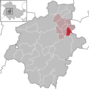
| Location of the municipality of Nottleben in the Gotha district | ||
  |
||

Nottleben is a municipality in the Gotha district in Thuringia . It belongs to the administrative community Nesseaue .
geography
Nottleben is located on the Nesse , northeast of the city of Gotha and north of the federal road 7 near Gamstädt . The village is located in an arable farming area in the Thuringian Basin . In the northwest of the town the Mollbach flows into the Nesse.
history
Nottleben was first mentioned in a document in 1168. It used to be called Notteleibin . At the end of the 15th century, the "Erfurt village" Nottleben became the seat of a large bailiwick of the Erfurt area , to which 12 other villages belonged. The place developed into a farming village with some very substantial farms. Since the administrative reform of 1706 he belonged to the Alach office . In 1802 Nottleben and the Erfurt area came to Prussia and between 1807 and 1813 to the French Principality of Erfurt . During the French occupation from 1806 to 1813, Nottleben had to pay for requisitions and supplies worth 18,600 Thalers. The damage caused by looting when the Napoleonic army withdrew in October 1813 was estimated at 23,000 thaler.
With the Congress of Vienna , the place came back to Prussia with the Amt of Alach and in 1816 was incorporated into the district of Erfurt in the Prussian province of Saxony . In 1887 the place had 560 inhabitants. Until the outbreak of the First World War, he experienced a positive development with Erfurt . From 1926 to 1967 Nottleben had a railway connection to Erfurt with the Erfurt – Nottleben small railway. During the Second World War Nottleben had even more casualties and missing persons than in the previous war. Again the women and prisoners of war had to take over the work of the drafted men.
US troops occupied the place on April 9, 1945 . Before that, there was artillery fire, which left nine civilians dead , including three children. 12 farmsteads were damaged or destroyed. The Nazi mayor was arrested and taken to a camp. The place had to take in many expellees. At the beginning of July, Nottleben became part of the SBZ . The LDPD emerged from the elections after 1945 as the strongest party. The mayor she appointed in 1946 was deposed in 1947 "because he could not keep up with developments". In 1954 a non-resident mayor came from the " Industrial workers in the country " campaign. In November 1945 a land reform commission was formed, which divided 75 hectares of land to 42 workers and poor peasants. In 1953 a LPG " Rosa Luxemburg " was founded, which in 1956 had 20 members and 73 ha. In 1956 the tower button was taken from the church tower. 38 entry and exit holes from 1945 had to be soldered. Some of the documents had become illegible as a result of the bombardment. Most of the information given here comes from the tower button, including the documents newly deposited in 1956. Nottleben later lost its parish and the church fell into disrepair.
As part of the Village Renewal Program in Thuringia after the reunification of the village square ( "Karl-Marx-Platz") was renewed from 2003 as the center of the village, the bakery to the community center redesigned and redeveloped the village inn. Many houses have lost their half-timbered facades under insulation panels.
Population development
Development of the population (December 31) :
|
|
|
|
|
- Data source: Thuringian State Office for Statistics
Sons and daughters of the church
- Ludwig Ernst Gebhardi (born January 1, 1787 in Nottleben; † May 29, 1862 in Erfurt), organist
- Johann Heinrich Schulze , grandfather and teacher of Johann Michael Hesse , the progenitor of the important family of organ builders from Dachwig
Attractions


The Peter and Paul Church was essentially built between 1427 and 1493, a reconstruction took place in 1521. The tower is five-story, structured by cornices, has a circumferential gallery parapet with gargoyles at the corners and a slender, slated spire. The nave had a three-sided choir closure and keel-arched portals on the north and south sides. During the GDR era, the church, the symbol of Nottleben, fell into disrepair. The roof of the nave had gaps since the early 1970s, over the years it fell into disrepair and the slate tiles fell off. Therefore the cemetery should be closed. There was a lack of craftsmen and materials to re-roof the roof, despite the efforts of the community in government and church offices. According to Lauszat, who studied the building files of the church, there were also “culpable reasons”. The equipment was exposed to the rain. The organ was rotting. A winged altar and figures from the church were preserved and initially transferred to the parish hall of the rectory. The artistically carved medieval altar was restored in the church workshops in Erfurt and, like the thick stone plate for the altar table and the pulpit, was taken over by the Church of St. Pankratius in Hochstedt in 1986 . A Pieta from around 1500 came to the Erfurt Angermuseum. In 1985 the roof of the nave was removed, only the outer walls remained and were secured. The entire nave was supposed to be blown up. The church tower, however, received a new slate roof in 1983. It was thoroughly renovated in 2008. It was accessible again after registration via an emergency ladder, today (2019) via a staircase from the nave. The three cast iron bells from 1919 are functional.
At the end of 2019, as part of its reconstruction, the nave appears with renovated walls, windows and a new roof with dormers.
The former station (1920s) of the (standard-gauge) Kleinbahn Erfurt – Nottleben , which was shut down in 1967, was converted into an attractive villa after the building was privatized after the fall of the Wall - unfortunately hidden from the view of the visitor through a high fence - as was the neighboring former engine shed has been preserved and renovated.
- Pictures of the church

Church from the Southeast (2010)

Church Interior (2010)

Church with rebuilt nave (2019)
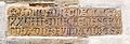
Brick with inscription
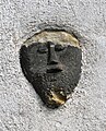
Stone mascaron on the church tower (perhaps to scare off evil spirits)
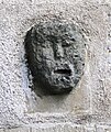
Stone mascaron on the church tower

Keystone on the side door of the nave
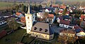
Aerial view of the church (2019)


.JPG)


Web links
Individual evidence
- ^ Population of the municipalities from the Thuringian State Office for Statistics ( help on this ).
- ↑ "Nottleben 1887–1956" . Copies of the documents that are in the tower button. Edited by Winfried Axmann, 1956
- ↑ Hellmuth Lauszat: The Church and its Churches . Erfurter Blätter, Messages from the Evangelical Church District, Volume 5, No. 3, 1995
- ^ Wieland Fischer: Tower of ruins saved . Thuringian regional newspaper, November 11, 2008
- ↑ Lydia Werner: Half a million euros for a new roof. The exterior of the ruins in Nottleben is to be turned into a church again in 2018 - the interior will still take time and money . Thüringische Landeszeitung, p. 19, 23 December 2017
Bad Tabarz | Bienstädt | Dachwig | Döllstädt | Three of a kind | Emleben | Eschenbergen | Friedrichroda | Friemar | Georgenthal | Gierstädt | Gotha | Großfahner | Manor | Earpiece | Luisenthal | Molschleben | Nesse-Apfelstädt | Nessetal | Emergency life | Ohrdruf | Horse life | Schwabhausen | Sonneborn | Tambach-Dietharz | Tonna | Tröchtelborn | Tüttleben | Waltershausen | Room supra