Alach
|
Alach
State capital Erfurt
Coordinates: 50 ° 59 ′ 12 ″ N , 10 ° 55 ′ 54 ″ E
|
|
|---|---|
| Height : | 299 (290-300) m |
| Area : | 10.1 km² |
| Residents : | 994 (December 31, 2016) |
| Population density : | 98 inhabitants / km² |
| Incorporation : | April 1, 1994 |
| Postal code : | 99090 |
| Area code : | 036208 |
|
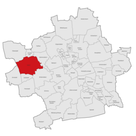
Location of Alach in Erfurt
|
|
Alach is a district of the Thuringian capital Erfurt . The village with about 1000 inhabitants is located west of the city on the Alacher Höhe .
geography
Alach is located about eight kilometers west of Erfurt city center on a plateau belonging to the Thuringian Basin , the Alacher Höhe. The Nesse , which flows to the west and belongs to the catchment area of the Weser , rises in the corridor, while Erfurt city center is located in the river area of the Elbe . While the place itself is almost 300 meters above sea level, the Alacher Höhe rises north of the place up to 329 meters. Neighboring villages of Alach are Zimmersupra in the west, Töttelstädt in the northwest, Schaderode in the north, Salomonsborn in the northeast, Marbach in the east, Bindersleben in the southeast and Gottstedt in the southwest. The flat town hall is not forested and is used intensively for agriculture.
history
The fertile area around Alach has been settled for a long time. For example, a burial ground from the Merovingian period was located in the corridor.
Alach was first mentioned in writing in the 9th century. From 1104 Alach belonged to the property of the Peterskloster in Erfurt, which is why the inhabitants of the place were called Peterlinge . Alach and Erfurt have had close ties since the 14th century, as the place belonged to the land of the city council. It was part of Kurmainz . In 1482 the mansion of the Alach monastery in the middle of the village was renovated. In 1664 Alach was besieged by Elector Johann Philipp von Schönborn , which caused considerable damage that could only be repaired at the beginning of the 18th century. During an administrative reform of the Erfurt state , the Alach office was formed in 1706 , to which 15 places belonged.
Since 1816 the parish village of Alach, which had a domain, belonged to the district of Erfurt in the Prussian province of Saxony . In 1822 there were 425 residents in 123 houses. There was a windmill outside the village . In 1932 the district was dissolved and Alach became part of the Weissensee district .
On July 1, 1950, the previously independent community Salomonsborn was incorporated. Another district of Alach is Schaderode , which has belonged to the municipality of Alach since the beginning of the Prussian era.
The Erfurt-Land district was formed in 1952 . On April 1, 1994, Alach and its two districts were incorporated into Erfurt. Today all three places form separate districts of Erfurt. The Alachs district council is still being formed together with Schaderode, while Salomonsborn has had its own district council since 2004.
Population development
- 1843: 598 (including Schaderode)
- 1910: 638 (including Schaderode)
- 1939: 707 (including Schaderode)
- 1995: 795
- 2000: 977
- 2005: 1041
- 2010: 1012
- 2015: 984
Attractions
- The center of Alach is still preserved in its historical form. Later, new housing estates were built to the south and after reunification to the northwest, so that the population rose sharply in the 1990s due to suburbanization .
- St. Ulrich village church
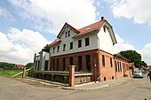
- Alach monastery
politics
Local mayor of Alach and Schaderode is Rainer Blasse.
Economy and Infrastructure
During the GDR era, Alach was exclusively dominated by agriculture, but is now also a location for various businesses. In addition to several small businesses, there are also two medium-sized companies: the Thuringian Post Service, which is now part of the PIN Group, and Limes Bau GmbH. The industrial park is east of the village on the road to Salomonsborn.
A road leads south to Bindersleben , where Erfurt Airport is directly adjacent to the town . When the airport was expanded, the road was relocated and rebuilt to the west. In addition, there is a junction to the federal highway 71 near Bindersleben , which leads around the town to the west and north. To the north a road leads to Schaderode and to the west to Zimmersupra and Töttelstädt . The through traffic is led along a bypass road on the eastern edge of the town.
The Erfurt transport company serves Alach with the city bus routes 91 and 92. The route 91 runs between Ermstedt and Büropark Airfurt, the 92 between Töttelstädt and the Büropark. From the Airfurt office park, tram line 4 runs towards the city center.
Between 1926 and 1967 the place had a stop on the Erfurt – Nottleben Kleinbahn , which made a connection to Erfurt Westbahnhof.
Personalities
Sons and daughters of the place
- Michael Altenburg (1584–1640), composer of hymns
- Samuel Friedrich Günther Wahl (1760–1834), orientalist
- Michael Gotthard Fischer (1773–1829), organist and composer
- Gotthold Donndorf (1887–1968), Protestant pastor, head of the Rauhen Haus in Hamburg
Individual evidence
- ^ Handbook of the Province of Saxony, Magdeburg 1843.
- ↑ gemeindeververzeichnis.de
- ↑ Michael Rademacher: German administrative history from the unification of the empire in 1871 to the reunification in 1990. (Online material for the dissertation, Osnabrück 2006).
- ↑ Population of the city districts
- ^ Carl Gustav Adolf Siegfried: Choice, Samuel Friedrich Günther . In: Allgemeine Deutsche Biographie (ADB). Volume 40, Duncker & Humblot, Leipzig 1896, p. 593 f.
literature
- Hans-Peter Brachmanski (ed.): History from chronicles of the place Alach. Alacher Festschrift , Erfurt 1996, 2nd edition 2007.
Web links
- Alach at www.erfurt.de ( Memento from November 9, 2011 in the Internet Archive )


