Herrenberg (Erfurt)
|
Herrenberg
City of Erfurt
Coordinates: 50 ° 57 ′ 31 ″ N , 11 ° 3 ′ 49 ″ E
|
|
|---|---|
| Area : | 1.69 km² |
| Residents : | 7936 (December 31, 2016) |
| Population density : | 4,696 inhabitants / km² |
|
Location of Herrenberg in Erfurt
|
|
|
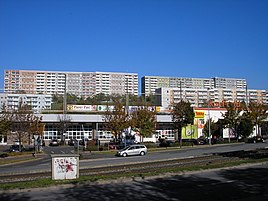
View from the Haarbergstrasse to the Herrenberg
|
|
The Herrenberg is a district of Erfurt characterized by prefabricated buildings .
It is located in the southeast of the city and is a range of hills between the Schwemmbachtal in the southwest and the Linderbachtal in the northeast. When a prefabricated building area was built on the hill in the 1970s, it was spun off from the Melchendorf district and has since formed its own district.
The Herrenberg begins on the street Am Rabenhügel ( Daberstedt ) and ends on the street Am Urbicher Kreuz, where it covers an area of 1.80 km². The area is accessed by tram lines 3 and 4 .
Like the other prefabricated districts of Erfurt, the Herrenberg is struggling with migration and aging. The peripheral location on the outskirts also has a disadvantageous effect.
Herrenberg also includes the Erfurt-Südost industrial park , where the semiconductor company X-FAB has a large branch.
Population development
The average age in the district is 45.8 years, which is almost 3 years above the city average. The population decreased rapidly from around 16,000 before the fall of the Wall and is now around 7,700. Both birth and migration balances are negative, so that the district will continue to shrink.
Data from the city administration of Erfurt as of December 31st.
| year | population | Development (1990 = 100%) |
Development in Erfurt (1990 = 100%) |
|---|---|---|---|
| 1990 | 15,282 | 100.0 | 100.0 |
| 1995 | 14,158 | 92.6 | 93.4 |
| 1996 | 13,675 | 89.5 | 91.9 |
| 1997 | 13,012 | 85.1 | 90.6 |
| 1998 | 12,342 | 80.8 | 89.3 |
| 1999 | 11,395 | 74.6 | 88.0 |
| 2000 | 10,652 | 69.7 | 87.6 |
| 2001 | 9,742 | 63.7 | 87.4 |
| 2002 | 8,944 | 58.5 | 87.2 |
| 2003 | 8,451 | 55.3 | 88.0 |
| 2004 | 7,993 | 52.3 | 88.4 |
| 2005 | 7,809 | 51.1 | 88.5 |
| 2006 | 7,701 | 50.4 | 88.4 |
| 2007 | 7,634 | 50.0 | 88.5 |
| 2008 | 7,977 | 52.2 | 88.5 |
| 2009 | 7,993 | 52.3 | 88.8 |
| 2010 | 8,032 | 52.6 | 89.2 |
| 2011 | 7,955 | 52.1 | 89.8 |
| 2012 | 7,937 | 51.9 | 90.4 |
| 2013 | 7,877 | 51.5 | 91.1 |
| 2014 | 7,894 | 51.7 | 91.7 |
| 2015 | 7,937 | 51.9 | 93.3 |
| 2016 | 7,936 | 51.9 | 93.9 |
politics
elections
| Political party | City Council 2009 | State Parliament 2009 | Bundestag 2013 | Europe 2009 |
|---|---|---|---|---|
| voter turnout | 32.0 | 41.5 | 48.9 | 32.0 |
| CDU | 17.0 | 19.4 | 25.1 | 19.2 |
| The left | 31.7 | 40.1 | 34.6 | 35.7 |
| SPD | 31.6 | 19.8 | 18.1 | 19.6 |
| Green | 4.8 | 5.8 | 4.1 | 5.6 |
| FDP | 3.3 | 5.3 | 1.3 | 4.8 |
Web links
Individual evidence
- ↑ Herrenberg district profile, Erfurt city administration, as of December 31, 2014


