
Löbervorstadt
|
Löbervorstadt
State capital Erfurt
Coordinates: 50 ° 58 ′ 5 ″ N , 11 ° 1 ′ 54 ″ E
|
|
|---|---|
| Height : | 220 m above sea level NN |
| Area : | 10.24 km² |
| Residents : | 12,429 (Dec. 31, 2016) |
| Population density : | 1,214 inhabitants / km² |
| Postal code : | 99096 |
| Area code : | 0361 |
 Location of the Löbervorstadt in Erfurt
|
|


The Löbervorstadt is one of the historical suburbs of Erfurt and at the same time a district of the Thuringian state capital.
It is the largest urban district in terms of area, as most of the Steigerwald belongs to the Löbervorstadt. The Erfurt city forest takes up two thirds of the district area. The development is on its northern slope and includes large Wilhelminian-style buildings on the border with the old town. In the following 100 years it expanded to the south and became more fragmented there with single-family houses. The Löbervorstadt is now regarded as a middle-class district with high rents. On Arnstädter Straße, the main street of the district, you will find the Thuringian state parliament and the city's largest sports facilities, the Steigerwald Stadium and the Gunda-Niemann-Stirnemann Hall . With the Thuringia Hall, the old town hall is located in the Löbervorstadt as well as most of the state ministries and the Erfurt sports high school .
The name Löber derives from the lowern from, the profession of tanner . These were previously located in Löberstraße, which in turn transferred its name to the city gate and from there to the suburb in front of it.
geography
The Löbervorstadt lies south of the old town and includes the area between Steigerstrasse in the west, Flutgraben in the north, Windthorst- / Friedrich-Ebert-Strasse in the east and the Steigerwald in the south. Neighboring districts are Brühlervorstadt in the west, the old town in the north, Daberstedt in the east, Herrenberg and Melchendorf in the southeast , the villages of Egstedt , Waltersleben , Möbisburg-Rhoda and Bischleben-Stedten in the south, beyond the Steigerwald , and Hochheim in the southwest.
The terrain of the Löbervorstadt is hilly and rises from the Gera valley in the north to the south to the Steigerwald. The lowest point of the district is at the main train station at a height of about 195 meters. The urban development extends to the south up to a height of about 250 meters, while the Stunzelberg in the very south of the district at Waldschlösschen is the highest point of the Steigerwald and the Löbervorstadt at 348 meters. To the west of Arnstädter Strasse, the Steigerwald pushes itself very steeply to the north; The Gera enters the center of Erfurt through a narrow valley breakthrough. To the east of Arnstädter Straße, on the other hand , the Schwemmbachtal has formed a hollow, behind which the Steigerwald rises a little further south. With the Bismarck Tower , there has also been an observation tower on the northern edge of the Steigerwald since 1901.
In the past, the part of the Löbervorstadt that is built up today was used for agriculture, while the Steigerwald has served as Erfurt's city forest since ancient times.
quarter
| Quarter (not official) |
Block groups (official) |
Area (km²) | Population (2000) | Population (2007) | Population (2015) | Population density |
|---|---|---|---|---|---|---|
| Lower Poets' Quarter (train - Arnstädter Straße - Geibelstraße - Freiligrathstraße - Parkstraße) |
211 + 212 + 213 | 0.69 | 3,542 | 3,583 | 3,972 | 5,757 |
| Upper Poets' Quarter (Geibelstrasse - Arnstädter Strasse - Arndtstrasse - Waldkasino - Freiligrathstrasse) |
214 + 215 | 0.47 | 1.941 | 1,794 | 1,789 | 3,806 |
| Music district (train - Windthorststraße - Johann-Sebastian-Bach-Straße - Arnstädter Straße) |
221 + 222 + 223 | 0.48 | 4,418 | 4,819 | 4,976 | 10,367 |
| Südpark / Stadion / Tannenwäldchen (Arnstädter Strasse - Johann-Sebastian-Bach-Strasse - Friedrich-Ebert-Strasse - Käthe-Kollwitz-Strasse - Seebachstrasse) |
224 | 1.89 | 1,168 | 1,248 | 1,844 | 976 |
| Steigerwald | 231 + 232 | 6.69 | 57 | 42 | 33 | 5 |
Lower poets' quarter
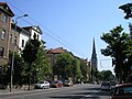
In the lower Dichterviertel in the northwest of the Löbervorstadt, the streets are named after famous writers. It was created after Erfurt was de-fortified as a bourgeois quarter for civil servants and industrialists with individual villas and apartment buildings. It was favored by its attractive location on the Steigerwald with relatively clean air. After the First World War, construction continued in the south of the district, with one and two-family houses built in green streets. The Hopfenberg, a hill overhanging the Puschkinstrasse as a visual axis to the cathedral , was designed in terms of urban planning . An excursion restaurant was built on the Hopfenberg and was and is the destination of walks for the townspeople.
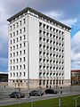
In the north of the district, further promenade paths and parks were created along the Gera. Next to a monument to the Mayor Richard Breslau of 1912 at the Löberstraße located in this park, the Thomas Church . The neo-Gothic building from 1902 is the district's Protestant parish church. Opposite it are the Friedrich Schiller regular school and the elementary school on the Steigerwald. Also in Schillerstrasse is the former Central German State Labor Office, a Bauhaus building from 1930, built by Johannes Klass . Opposite it is the old Ministry of the Interior, a large Wilhelminian style building that has been converted into apartments. The Thuringia branch of the trust property company is located in the district on Arnstädter Straße . Your building was erected in 1958 in the style of socialist modernism as the administrative headquarters of the Kali combine , which was responsible for the salt production of the GDR. Next to it is the Heinrich-Mann-Gymnasium in the school building from 1930. On the corner of Arnstädter Strasse and Viktor-Scheffel-Strasse is one of the oldest still operating gas stations in Germany, built in 1930 in the Bauhaus style, also by Johannes Klass. In addition, the seat of the IHK Erfurt is in the building of the former district youth school.
Upper poet's quarter
The upper poet's quarter in the southwest emerged in the middle third of the 20th century as a residential area with single-family and semi-detached houses for civil servants and employees. Small houses and a lot of green dominate. At the edge of the forest in the south of the district is the Waldkasino, a traditional excursion restaurant with a panoramic view of the city. On the other side of Martin-Andersen-Nexö-Straße are the municipal tennis courts, where the Erfurt TC Rot-Weiß plays tennis in the 1st Bundesliga. To the east lies a large fallow land, on which a factory of the Lingel shoe factory , during the GDR era Paul Schäfer shoe factory , stood until the turn of the millennium . It was one of the largest companies in Erfurt in the late 19th and 20th centuries and was closed after reunification.
Music district
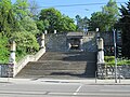
The music district is the most densely built-up area in the Löbervorstadt. It is located in the north-east and is characterized by large, partly isolated apartment buildings from the period between 1880 and 1910. Here the streets are named after important composers. On the Daberstedter Schanze, which was previously part of the city fortifications, the city park was created shortly before the First World War . It is relatively small and is dominated by the monumental, neoclassical staircase leading to the main station. On the other side of Schillerstrasse, there is also a park along the Gera on the northern edge of the music district. To the west of the city park is the site of the former Braugold brewery (1888–2010).
The most important institution in the music district is the Thuringian state parliament with the parliamentary building from 1939 on Arnstädter Straße, the high-rise building on Johann-Sebastian-Bach-Straße from 1951 and the new plenary hall in between from 2003 Monumental building of the Ministry of Agriculture . It was built in 1929 in the neoclassical style as the headquarters of the post office directorate and has a total of 150 meters long facade.
Southern Löbervorstadt
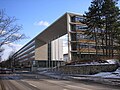
To the south of Johann-Sebastian-Bach-Strasse is an urban area that does not serve as a residential area. There are numerous institutions that are important for the city and region. Erfurt's sports center is located on Mozartallee. These include the Steigerwaldstadion , in which FC Rot-Weiß Erfurt plays its home games of the 3rd Bundesliga, the Gunda-Niemann-Stirnemann-Halle , where the European speed skating championships were held in 2002, the southern swimming pool and the Pierre de Coubertin sports high school , which already has several Produced Olympic champions. On the east side of Mozartallee is the Südpark , which emerged from the Südfriedhof, which was closed in 1978.
To the south of the sports complex there are other important facilities along Werner-Seelenbinder-Straße. At the beginning there is the House of Thuringian Sports, seat of the state sports association, which was built in the 19th century as a rifle house. Next to it is the Thuringia Hall from 1940, which was the largest hall in the city until the exhibition hall opened. The cemetery of the Jewish state community of Thuringia from 1871 is adjacent to it. This is followed by a building complex of the state government, in which most of the ministries are housed. It was mostly built between 1994 and 2001 for the re-established federal state, including the buildings of the former garrison hospital from the mid-1930s. In the east on Kranichfelder Straße is the Löberfeld barracks of the Bundeswehr. To the south of these buildings there are still some gardens on the edge of the Steigerwald and the mountain barracks of the Bundeswehr, which is already surrounded by forest. The Bismarck Tower , a lookout tower from 1901, is also located here.
Population development
The population of the Löbervorstadt in 1990 was around 13,000. By 1997, the number had fallen by a fifth to 10,500. The main reason was the poor housing situation in the unrenovated old building districts, which often did not have bathrooms or central heating systems. The main goals of those moving away were other parts of Erfurt, especially the growing village suburbs (strong wave of suburbanization during the 1990s), but some turned their backs on the city due to the poor economic situation. The renovation work on the building fabric began a short time after reunification and in 2009 reached a relatively high degree of area coverage. However, there are also vacant, unrenovated buildings, for example the large former administrative complex on Kaffeetrichter, which is now also being refurbished to a high standard and planned with the legally binding development plan LOV 577. The housing estates in the south of the Löbervorstadt remained largely unaffected by these redeployment processes.
A building census in 2006 showed that there are 1,454 buildings in Löbervorstadt, which contained 5711 apartments, of which 566 or 10% were vacant. By 2009, the number of apartments had fallen to 5,613 (for example through conversion to business premises or merging), while the number of buildings remained almost constant at 1,452 and the vacancy rate fell to 514 apartments (9.2%).
Since 1997, the population of the Löbervorstadt has been slowly growing again, with growth being limited to the Wilhelminian-style district in the north. The birth balance is negative, but it is offset by a positive migration balance. In the middle-class district with high rents, 35 to 55 year olds make up the largest population group with an average age of 44 years. In the future, the population of the Löbervorstadt can increase a little if vacant buildings are renovated and occupied. The construction of new residential buildings is likely to be difficult due to geographical conditions, so there are no suitable areas available. A return to the population of 1990 is rather unlikely, as the required living space per capita is much higher today than in 1990 and in GDR times, which means that fewer people live in an apartment that has remained the same size today than before. In addition, in the Löbervorstadt in particular, living space was converted into business space, which is why there is absolutely less living space available than in 1990. In 2010, 224 foreigners lived in the Löbervorstadt, which corresponds to a share of 1.9% and thus below the city average of 3 .3%. In addition, the Löbervorstadt is the district with the most secondary residences : almost 500 people have a secondary residence here, mainly weekend commuters from politics, business, administration and science. In the other parts of the city there are significantly fewer secondary residences due to the second home tax levied .
Data from the city administration of Erfurt as of December 31st.
| year | population | Development (1990 = 100%) |
Development in Erfurt (1990 = 100%) |
|---|---|---|---|
| 1990 | 13,370 | 100.0 | 100.0 |
| 1995 | 11,022 | 82.4 | 93.4 |
| 1996 | 10,564 | 79.0 | 91.9 |
| 1997 | 10,476 | 78.4 | 90.6 |
| 1998 | 10,823 | 80.9 | 89.3 |
| 1999 | 10,901 | 81.5 | 88.0 |
| 2000 | 11,127 | 83.2 | 87.6 |
| 2001 | 11,145 | 83.4 | 87.4 |
| 2002 | 11,185 | 83.7 | 87.2 |
| 2003 | 11,326 | 84.7 | 88.0 |
| 2004 | 11,349 | 84.9 | 88.4 |
| 2005 | 11,384 | 85.1 | 88.5 |
| 2006 | 11,426 | 85.5 | 88.4 |
| 2007 | 11,486 | 85.9 | 88.5 |
| 2008 | 11,544 | 86.3 | 88.5 |
| 2009 | 11,505 | 86.1 | 88.8 |
| 2010 | 11,623 | 86.9 | 89.2 |
| 2011 | 11,881 | 88.9 | 89.8 |
| 2012 | 11,991 | 89.7 | 90.4 |
| 2013 | 12,081 | 90.4 | 91.1 |
| 2014 | 12.123 | 90.7 | 91.7 |
| 2015 | 12,614 | 94.3 | 93.3 |
| 2016 | 12,429 | 93.0 | 93.9 |
Economy and Transport
While the north and west of the Löbervorstadt are almost entirely residential areas, there are numerous well-paid jobs in the administrative facilities along Arnstädter Strasse and in the south. That is why there are many commuters who drive to work in the Löbervorstadt. Compared to the service providers, the industry (with the shoe factory) completely disappeared after 1990. The importance of the military as an employer has also decreased compared to earlier times, as the Löbervorstadt was at times one of the most important barracks in Central Germany.
The main thoroughfares in Löbervorstadt are Schillerstrasse in an east-west direction and Arnstädter Strasse in a north-south direction. They meet at the coffee funnel , a central traffic junction in the district. Bundesstrasse 4 and Bundesstrasse 7 run along the city ring . The federal highway 4 leads in the Löbervorstadt over the Steigerwald and is important as a motorway feeder to the federal highway 4 . Other important connecting roads are Johann-Sebastian-Bach-Strasse and Werner-Seelenbinder-Strasse. The Löbervorstadt is connected to public transport via lines 1, 3, 4 and 6 of the Erfurt tram . Line 1 runs on Arnstädter Straße to Thüringenhalle, line 6 on Schillerstraße to Steigerstraße and lines 3 and 4 run along Windthorst- / Friedrich-Ebert-Straße in the east of the district. The main train station is also on the border with the district in the northeast. Its western approach, the Thuringian Railway , also crosses the district, but without stopping. The Gera cycle path also leads through the Löbervorstadt.
Politics and elections
Since the Löbervorstadt forms a district, but not a district according to § 45 of the Thuringian municipal code, there are no political bodies for it such as the district council or the district mayor.
The Löbervorstadt is part of the Erfurt III state electoral district , for which Marion Walsmann (CDU) sits in the sixth Thuringian state parliament. She received 33.8% of the votes in the district. The Löbervorstadt is considered to be a rather middle-class district with a high proportion of older, well-paid residents. Therefore both the voter turnout and the results of the CDU, Greens and FDP are slightly higher than the city average. In contrast, the SPD is average, and Die Linke performs below average.
| Political party | City Council 2009 | State Parliament 2009 | Bundestag 2009 | Europe 2009 |
|---|---|---|---|---|
| voter turnout | 46.3 | 53.6 | 58.9 | 46.4 |
| CDU | 22.1 | 26.7 | 36.6 | 25.5 |
| The left | 13.8 | 21.2 | 18.0 | 18.8 |
| SPD | 34.9 | 21.4 | 18.2 | 19.7 |
| Green | 13.1 | 16.2 | 11.4 | 15.5 |
| FDP | 6.2 | 8.8 | 3.6 | 8.4 |
gallery

Am Stadtpark (music district)
The Schillerstraße in the lower Dichterviertel with the Thomaskirche

The Obere Dichterviertel is characterized by private homes such as here on Eichendorffstrasse / Geibelstrasse

Gunda-Niemann-Stirnemann Hall and Steigerwald Stadium

Aerial view of the St. Thomas Church

Heinrich-Mann-Gymnasium

TLG building

Ministry of Agriculture
Complex of the state ministries

Portal of the state parliament
High-rise of the state parliament
View of the Daberstedter Schanze (access to the city park)


Web links
- Population - districts - Löbervorstadt. (No longer available online.) In: erfurt.de. Formerly in the original ; accessed on November 18, 2017 . ( Page no longer available , search in web archives )
- Erfurt Statistics - Data and Facts 2011 ( Memento from September 24, 2011 in the Internet Archive ). In: erfurt.de (PDF; 1.2 MB)
Individual evidence
- ↑ block group map ( Memento of 17 June 2012 at the Internet Archive ). In: erfurt.de, accessed on November 18, 2017 (PDF; 3.5 MB).
- ↑ Satellite measurement with Google Earth, there may be slight deviations (<3%)
- ↑ Population statistics 2000 ( Memento from June 17, 2012 in the Internet Archive ) (= Kommunalstatistische Hefte. Issue 41/1. Edition: April 2001), p. 49. In: erfurt.de, accessed on November 18, 2017 (PDF; 1 , 3 MB).
- ↑ Population statistics 2007 ( Memento from June 17, 2012 in the Internet Archive ) (= Kommunalstatistische Hefte. Issue 64. Edition: July 2008), p. 54. In: erfurt.de, accessed on November 18, 2017 (PDF; 937 kB) .
- ↑ Population statistics 2015 (= municipal statistics booklet. Issue 96. Edition: November 2016), p. 56 ff. In: erfurt.de, accessed on November 18, 2017 (PDF; 3.9 MB).
- ↑ Building and housing stock 2006 update ( Memento of October 26, 2010 in the Internet Archive ) (= municipal statistics booklet. Issue 62. Edition: 07/2007). In: erfurt.de, accessed on November 18, 2017 (PDF; 994 kB).
- ↑ Stadtverwaltung Erfurt: Erfurt Statistics - Buildings and Housing Stock 2009 ( Memento from June 1, 2010 in the Internet Archive ) (= Municipal Statistics Hefts . Issue 73. Edition: 07/2010) (PDF; 659 kB), p. 23. In: erfurt.de, accessed on November 18, 2017.
- ↑ Erfurt statistics. Population 2010 ( Memento from December 28, 2011 in the Internet Archive ) (= municipal statistics booklet. Issue 75th edition: 07/2011), p. 42. In: erfurt.de, accessed on November 18, 2017 (PDF; 1.9 MB).

Districts: Old Town | Andreasvorstadt | Berliner Platz | Brühlervorstadt | Daberstedt | Herrenberg | Hohenzüge | Ilversgehofen | Johannesplatz | Johannesvorstadt | Krmpfervorstadt | Löbervorstadt | Melchendorf | Moscow Square | Rieth | Red Mountain | Meadow hill
Districts: Alach | Azmannsdorf | Bindersleben | Bischleben and Stedten | Büßleben | Dittelstedt | Egstedt | Ermstedt | Frienstedt | Gispersleben | Gottstedt | Hochheim | Hochstedt | Kerspleben | Kühnhausen | Linderbach | Marbach | Mittelhausen | Möbisburg-Rhoda | Molsdorf | Niedernissa | Rohda (Haarberg) | Salomonsborn | Schaderode | Schmira | Schwerborn | Stotternheim | Sulzer settlement | Deep valley | Töttelstädt | Killing life | Urbich | Vieselbach | Wallichen | Waltersleben | Windischholzhausen