
Krmpfervorstadt
|
Krmpfervorstadt
State capital Erfurt
Coordinates: 50 ° 58 ′ 50 ″ N , 11 ° 2 ′ 25 ″ E
|
|
|---|---|
| Height : | 200 m above sea level NN |
| Area : | 4.96 km² |
| Residents : | 16,340 (Dec. 31, 2016) |
| Population density : | 3,294 inhabitants / km² |
| Postal code : | 99085 |
| Area code : | 0361 |
 Location of the Krmpfervorstadt in Erfurt
|
|


The Krämpfervorstadt is one of the historic Erfurt suburbs and at the same time a district of the Thuringian state capital. It has over 15,000 inhabitants on an area of 4.96 km². It is located east of the old town between Schlachthofstrasse in the north, the Flutgraben in the west and the Thuringian Railway in the south.
The Krämpfervorstadt is divided into two parts: to the west of the Nordhäuser and Sangerhäuser Bahn there are quarters with large apartment buildings that were built between 1880 and 1960, while the Ringelberg, one of the largest single-family housing estates in the city, is east of the railway lines. Of the 15,000 inhabitants, 11,000 live in the western and 4000 in the eastern part of the Krmpfervorstadt. Furthermore, the district is dominated on the one hand by extensive railway systems and associated commercial areas, on the other hand by the campus of the Erfurt University of Applied Sciences with around 5000 students.
The Krämpfervorstadt is a demographically young district due to a comparatively high proportion of students. As a result of renovation and other urban development measures, the old building districts have been significantly upgraded since reunification, while businesses were shut down and new fallow land was created in some cases.
The name Krämpfervorstadt is derived from the location in front of the Krämpfertor, which probably got its name from the Kaufmannskirche am Anger and Krmpfer , like Krämer , is a synonym for Kaufmann.
geography
The Krmpfervorstadt borders on the old town to the west , with the Gera flood ditch marking the border. In the south, beyond the Thuringian Railway, the district of Daberstedt and in the north on Schlachthofstrasse borders the Johannesvorstadt . These two districts are structured in a similar way to the Krämpfervorstadt, while the three rural villages of Kerspleben , Azmannsdorf and Linderbach border to the east.
The terrain of the Krämpfervorstadt is flat in the west and rises to the Ringelberg to the east . It is also the watershed between Gera in the west and Gramme in the east. The lowest is the northern border to Johannesvorstadt on Schlachthofstraße at about 190 meters, while the southern border to Daberstedt at the freight yard is already at about 200 meters. The highest point is the 226-meter-high Ringelberg, which breaks off relatively steeply to the Geratal valley to the west, merges into the Galgenberg to the north and gently slopes down to the Linderbach valley to the south and east .
In addition to the areas occupied by residential and commercial areas, the premises of DB Regio Südost for Thuringia and other extensive track systems are located in the Krämpfervorstadt . The southeast of the district is still used for agriculture, as was the case in the entire area of today's district before the clearance of the area in front of the Erfurt Fortress in 1873. Since 1990 the development has been expanding again and taking up new areas.
quarter
| Quarter (not official) |
Block groups (official) |
Area (km²) | Population (2000) | Population (2007) | Population (2015) | Population density |
|---|---|---|---|---|---|---|
|
Hanseviertel (Stauffenbergallee - Schlachthofstraße - Greifswalder Straße - Leipziger Straße) |
811 + 812 + 813 + 814 | 0.40 | 4,410 | 4,750 | 4,921 | 12.303 |
| Inner Krämpfervorstadt (Stauffenbergallee - Leipziger Straße - Rathenaustraße - Raiffeisenstraße) |
821 + 823 + 824 | 0.29 | 2,913 | 3,809 | 4,599 | 15,859 |
| Outer Krämpfervorstadt (Leipziger Straße - Nordhäuser Bahn - Rathenaustraße) |
822 + 825 | 0.55 | 1,695 | 2.164 | 2,438 | 4,433 |
| Old Ringelberg | 831 | 0.73 | 862 | 728 | 689 | 944 |
| Freight station / Kalkreiße | 832 | 2.18 | 82 | 97 | 138 | 63 |
| New Ringelberg | 833 + 834 + 835 | 0.76 | 2.163 | 3,056 | 3,498 | 4,603 |
Hanseviertel
see main article: Hanseviertel
The Hanseviertel occupies the northern part of the Krämpfervorstadt between Schlachthofstrasse and Leipziger Strasse. It was a focus of residential construction by private companies, so that here in the Weimar Republic apartment buildings of well-known architects in the Bauhaus style were built. After the Second World War, this construction activity continued, albeit in the form of monotonous old new buildings . In addition, the campus of today's Erfurt University of Applied Sciences was started in the Hanseviertel in 1946 .
Inner Krampfer suburb
The inner Krämpfervorstadt extends to the west of the district between Stauffenbergallee and Rathenaustraße as well as Leipziger Straße and Raiffeisenstraße. It is most clearly characterized by dense Wilhelminian-style buildings. Here lies Leipziger Platz, one of the central squares of the district. While the houses are on the streets, the inner courtyards were largely characterized by commercial use. The most important building in the district is the disused and unused Wolff Malzfabrik , which occupies a large area on Thälmannstrasse.
Between 1994 and 1999 the Krmpfervorstadt was a support area of the EU project URBAN to upgrade neglected urban quarters. The funding volume was around 17 million euros. However, a total of 136 million euros from private and public investors were put into the quarter through synergy effects, which was one of Urban’s central goals. Overall, the project was successful because the quality of life in the Krmpfervorstadt could be increased significantly over the period.
However, some streets in the south of the district are still struggling with relatively high vacancy rates. In a certain way, the somewhat isolated urban location with no tram connection has a disadvantageous effect, and the railway systems in the south and the expressways as well as the flood ditch in the west create additional barriers for pedestrians and cyclists when it comes to the quick accessibility of the southern quarter.
Outer Krampfer suburb
The outer Krämpfervorstadt lies between Rathenaustraße in the west, Leipziger Straße in the north and the railway systems in the east and south. It is strongly characterized by the mixture of commercial and residential areas and also includes some fallow areas. The living areas are mainly in the west and date from different epochs of the 20th century. The commercial areas in the east were among the oldest industrial areas in Erfurt and benefited above all from their location directly on several railway lines. However, they have been struggling with major structural change, especially since 1990, and are rather unattractive compared to new commercial areas due to their poor road connections.
In the north of the district is Hanseplatz, which was redesigned with EU funding in 1999 and today serves as an inner-city green space. The vacancy rate in the outer Krmpfervorstadt is still relatively high, but has been falling steadily since 2000. At that time only 1695 inhabitants lived there, in 2009 there were already 2231 people.
In 2015, public participation began as part of the planning process in which the city of Erfurt wants to convert the current mixed and commercial areas in the outer Krämpfervorstadt into a residential area. A four-storey building with rental apartments is planned in order to be able to settle around 3000 additional residents. This project is related to the development of the ICE-City Ost, which is to be built on the old freight station on the adjoining area to the south. A new tram route from the main train station through the quarter to the old Nordhausen train station on Leipziger Strasse is also under discussion, with a long-term planning horizon until 2035 for the completion of all projects. In 2015, an integrated urban planning framework was adopted for the area, which specifies the planning. This will include 2,375 apartments or a total living space of 237,500 square meters, on which around 5,000 additional residents could live.
Old Ringelberg
In 1957, the first residential estate with small single-family houses was built on the slope of the Ringelberg in the area of the Ringelberg stairs on Leipziger Strasse. To the south of it there are extensive gardens that also date from the early GDR period. In between, also on Leipziger Strasse, is a large shopping center to supply the surrounding quarters. The Thuringia milk works are also located there, which are part of the Humana Milchunion and process around 1.1 million liters of milk every day. The products of Milchwerke Thuringia are sold in East Germany under the Osterland brand .
The old Ringelbergsiedlung is today, like most settlements from this period, characterized by an aging and declining population.
New Ringelberg
The new Ringelbergsiedlung was, along with Marbach, one of the two main focuses of residential building close to the city in the 1990s. It was built to the east and above the old Ringelbergsiedlung directly on the hill and is designed in such a way that it could be expanded significantly if there was an increased demand for new homes. The main street of the settlement is Walter-Gropius-Straße, on which the tram line 2 also runs and currently ends in the middle of a green meadow . Construction work on the Ringelberg is not yet complete, but has slowed down significantly. The streets on the Ringelberg are named after Bauhaus artists and in some ways stand in contrast to the relatively monotonous development of the 1990s.
Freight station, Kalkreiße, Krmpferflur
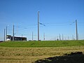
The south of the district is characterized by Erfurt's railway systems. Since the main train station is spatially confined in the old town, the facilities required to operate the railway were built further east in the Krmpfervorstadt. This is where the freight station is located, which is rarely used; for example, container loading between road and rail takes place in the freight transport center near Vieselbach a few kilometers to the east . Furthermore, the workshops of the DB Regio Südost , Verkehrsbetrieb Thuringia belong to the facilities of the railway. The local trains of the DB Regio , which are used in Thuringia, are stationed here. The Nordhausen – Erfurt and Sangerhausen – Erfurt lines join the Thuringian Railway from the north, and in the early days they ended at their own stations on Leipziger Strasse. There is a connection in the direction of Weimar via the freight station, while passenger trains thread over a curved track and a ramp in the direction of Erfurt Hbf. The Kalkreiße industrial park with numerous small businesses is located on this curved track. It takes its name from a former lime mill and brick kiln. To the east of this is the Krmpferflur, which is used for agriculture. There are also some allotments here.
Population development
The population of the Krmpfervorstadt in 1990 was around 14,000. By 1997 the number had fallen by a fifth to around 11,000. The main reason was the poor housing situation in the unrenovated old districts of the Krmpfervorstadt, which often did not have bathrooms or central heating systems. The main goals of those moving away were other parts of Erfurt, especially the growing village suburbs (strong wave of suburbanization during the 1990s), but some turned their backs on the city due to the poor economic situation. The renovation work on the building fabric began a short time after reunification and in 2009 achieved a medium level of area coverage. There are sections of empty, unrenovated buildings, for example on the busy Stauffenbergallee and in side streets in the southern area at the freight yard. The campus of the university of applied sciences has existed since around 1950, which became a demographic factor of the Krmpfervorstadt. Many students moved into the quarter, and with the introduction of the second home tax in Erfurt in 2003, it was also achieved that these students register their main residence in Erfurt and are thus recorded in the population statistics. The most important factor in the demographic development of the Krämpfervorstadt in recent years, however, was the construction of the New Ringelberg, which brought 3,000 new residents to the district. Without this increase, the population would only be around 11,500 and thus well below the level of 1990.
A building census in 2006 showed that there are 1678 buildings in the Krämpfervorstadt with 7947 apartments, of which 898 or 11% were vacant. 40 houses with 261 apartments were completely empty. By 2009 the number of apartments increased slightly to 7,988, the number of buildings also rose to 1,719, while the vacancy rate fell to 803 apartments (10.1%). The number of complete vacancies fell slightly in the three years and is now 35 buildings with 249 apartments.
In the future, the number of inhabitants in the Krmpfervorstadt can continue to rise if one assumes that the vacant buildings in the district will be further refurbished with simultaneous influx. In addition, the Neue Ringelberg can also be expanded, so the last section of the tram route currently runs over a green meadow crossed by paths.
The population structure of the Krmpfervorstadt is demographically favorable, the 20 to 30 year olds make up the largest group of the population, with the proportion of women slightly higher than the proportion of men. The birth rate (around 180 births per year) is therefore around twice as high as the death rate (around 90 deaths per year), the migration balance is also positive, which is why the Krmpfervorstadt will continue to grow. Around 700 foreigners live in the district, which corresponds to a share of 4.7% and is thus above the Erfurt average of around 3.3%.
Data from the city administration of Erfurt as of December 31st.
| year | population | Development (1990 = 100%) |
Development in Erfurt (1990 = 100%) |
|---|---|---|---|
| 1990 | 13,825 | 100.0 | 100.0 |
| 1995 | 11,724 | 84.8 | 93.4 |
| 1996 | 10,906 | 78.9 | 91.9 |
| 1997 | 10,814 | 78.2 | 90.6 |
| 1998 | 11,165 | 80.8 | 89.3 |
| 1999 | 11,569 | 83.7 | 88.0 |
| 2000 | 12,125 | 87.7 | 87.6 |
| 2001 | 12,535 | 90.7 | 87.4 |
| 2002 | 12,921 | 93.5 | 87.2 |
| 2003 | 13,464 | 97.4 | 88.0 |
| 2004 | 14,105 | 102.0 | 88.4 |
| 2005 | 14,315 | 103.5 | 88.5 |
| 2006 | 14,499 | 104.9 | 88.4 |
| 2007 | 14,604 | 105.6 | 88.5 |
| 2008 | 14,669 | 106.1 | 88.5 |
| 2009 | 14,867 | 107.5 | 88.8 |
| 2010 | 15,032 | 108.7 | 89.2 |
| 2011 | 15,395 | 111.4 | 89.8 |
| 2012 | 15,601 | 112.8 | 90.4 |
| 2013 | 15,925 | 115.2 | 91.1 |
| 2014 | 16,072 | 116.3 | 91.7 |
| 2015 | 16,283 | 117.8 | 93.3 |
| 2016 | 16,340 | 118.2 | 93.9 |
Economy and Transport
The most important employers in the Krmpfervorstadt are the University of Applied Sciences Erfurt , the Deutsche Bahn as well as the industrial companies on the Kalkreiße and the Milchwerke Thuringia. Trade and other services tend to play a subordinate role and serve to supply the immediate resident population.
The main street of the district is Leipziger Strasse, which used to run as Via Regia from Frankfurt am Main via Erfurt to Leipzig and on to Kiev . Today it is the main road from Erfurt to Kerspleben and Buttelstedt . The Leipziger Platz and Hanseplatz are also the two most important squares in the district. The city ring runs across Leipziger Strasse on Stauffenbergallee and Liebknechtstrasse / Thälmannstrasse. The Geschwister-Scholl-Straße is the old connection to Azmannsdorf and today serves to develop the industrial areas of the Krämpfervorstadt as well as the Thuringian chain of cities long-distance cycle route .
The Krämpfervorstadt is connected to local public transport by line 2 of the Erfurt tram on Leipziger Straße. It was laid out as far as the railway bridges in 1904, but closed again in 1922. It was followed by a line of the trolleybus' Erfurt (between 1953 and 1975), which led to the Ringelbergtreppe. In 2000 the current tram route was completed up to the Ringelberg, which was accompanied by a complete redesign of Leipziger Straße. Bus line 9 runs across the tram with the intersection at Leipziger Platz. Other city bus routes ensure the connection to other parts of the city. Although three railway lines run through the Krmpfervorstadt, since the closure of the Nordhäuser and Sangerhausen stations at the end of the 19th century, it no longer has access to train traffic. In connection with the planned urban redevelopment in the outer Krämpfervorstadt by 2030, a long-term stop for local trains on Leipziger Strasse is also being considered.
elections
Since the Krämpfervorstadt forms a district, but not a district according to § 45 of the Thuringian municipal code, there are no political bodies for it, such as the district council or the district mayor.
The Krmpfervorstadt is part of the Landtag constituency Erfurt III , the home constituency of the Thuringian Prime Minister Bodo Ramelow (Die Linke). The Krmpfervorstadt was traditionally a working-class district, but today all social classes are found here with an overrepresentation of young people, especially students, while the affluent upper classes are rather underrepresented. This is also reflected in the district's election results, which are not only characterized by a low turnout, but also by a strengthening of the left and the Greens and, in contrast, a weak CDU. The results of the SPD and FDP, on the other hand, are in line with the Erfurt average.
| Political party | City Council 2009 | State Parliament 2009 | Bundestag 2013 | Europe 2009 |
|---|---|---|---|---|
| voter turnout | 38.7 | 44.2 | 54.9 | 38.9 |
| CDU | 18.4 | 21.5 | 31.9 | 21.1 |
| The left | 19.7 | 29.4 | 24.2 | 23.5 |
| SPD | 34.6 | 20.8 | 17.7 | 20.5 |
| Green | 11.1 | 12.2 | 8.4 | 12.2 |
| FDP | 5.8 | 7.8 | 2.3 | 7.3 |
gallery

The University of Applied Sciences on Altonaer Strasse in the Hanseviertel
Flensburg Block on the corner of Kieler Strasse and Liebknechtstrasse in the Hanseviertel

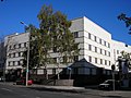
The medical college at Leipziger Platz
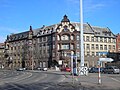
Wilhelminian style buildings on Raiffeisenstrasse in the inner Krmpfervorstadt

The Raiffeisenstrasse at the freight yard is characterized by high vacancy rates

House of People's Solidarity in Thälmannstrasse

Former Wolff malt factory on Iderhoffstrasse

View from the median of Stauffenbergallee
The end of the tram on the Ringelberg

The Ringelbergsiedlung with new houses on the left and old houses on the right
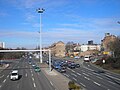
The Schmidtstedter knot on the southwestern edge of the district


Web links
- District - Krämpfervorstadt. Population with main residence on December 31, 2012 ( memento from February 10, 2013 in the web archive archive.today ). In: erfurt.de
- Project website of the city administration for the urban development of the Outer East City. In: erfurt.de
- Information on the URBAN project of the EU in the Krämpfervorstadt ( Memento from November 8, 2007 in the Internet Archive )
- Erfurt Statistics - Data and Facts 2011 ( Memento from September 24, 2011 in the Internet Archive ). In: erfurt.de (PDF; 1.2 MB)
- Erfurt Statistics - Population 2011 ( Memento from January 27, 2013 in the Internet Archive ) (= municipal statistics booklets. Issue 79, edition: August 2012). In: erfurt.de (PDF; 1.8 MB)
Individual evidence
- ↑ block group map ( Memento of 17 June 2012 at the Internet Archive ). In: erfurt.de, accessed on November 20, 2017 (PDF; 3.5 MB).
- ↑ Satellite measurement with Google Earth, there may be slight deviations (<3%).
- ↑ Population statistics 2000 ( Memento from June 17, 2012 in the Internet Archive ) (= Kommunalstatistische Hefte. Issue 41 / 1st edition: April 2001), p. 47. In: erfurt.de, accessed on November 20, 2017 (PDF; 1 , 3 MB).
- ↑ Population statistics 2007 ( Memento from June 17, 2012 in the Internet Archive ) (= Kommunalstatistische Hefte. Issue 64. Edition: July 2008), p. 53. In: erfurt.de, accessed on November 20, 2017 (PDF; 937 kB) .
- ↑ Population statistics 2015 (= municipal statistics booklet. Issue 96. Edition: November 2016), p. 56 ff. In: erfurt.de, accessed on November 20, 2017 (PDF; 3.9 MB).
- ↑ Steffen Raßloff : Civil War and the Roaring Twenties. Erfurt in the Weimar Republic. Sutton, Erfurt 2008, ISBN 978-3-86680-338-1 , p. 69 ff.
- ↑ Holger Wetzel: Krämpfervorstadt in Erfurt gets residential area for 3000 people. In: Thuringian General . March 10, 2015, accessed November 20, 2017.
- ↑ How on in the Outer East City? Citizens' dialogue of the city administration. (No longer available online.) In: erfurt.de. March 10, 2015, archived from the original on December 1, 2017 ; accessed on February 21, 2019 .
- ↑ Integrated urban planning framework. Outer East City. Final report. In: erfurt.de. September 2015, accessed on November 20, 2017 (PDF; 10.2 MB).
- ↑ Building and housing stock 2006 update ( Memento of October 26, 2010 in the Internet Archive ) (= municipal statistics booklet. Issue 62. Edition: 07/2007). In: erfurt.de, accessed on November 18, 2017 (PDF; 994 kB).
- ↑ Stadtverwaltung Erfurt: Erfurt Statistics - Buildings and Housing Stock 2009 ( Memento from June 1, 2010 in the Internet Archive ) (= Municipal Statistics Hefts . Issue 73. Edition: 07/2010) (PDF; 659 kB), p. 23. In: erfurt.de, accessed on November 18, 2017.
- ^ Election portal of the city of Erfurt. In: erfurt.de, accessed on November 20, 2017.

Districts: Old Town | Andreasvorstadt | Berliner Platz | Brühlervorstadt | Daberstedt | Herrenberg | Hohenzüge | Ilversgehofen | Johannesplatz | Johannesvorstadt | Krmpfervorstadt | Löbervorstadt | Melchendorf | Moscow Square | Rieth | Red Mountain | Meadow hill
Districts: Alach | Azmannsdorf | Bindersleben | Bischleben and Stedten | Büßleben | Dittelstedt | Egstedt | Ermstedt | Frienstedt | Gispersleben | Gottstedt | Hochheim | Hochstedt | Kerspleben | Kühnhausen | Linderbach | Marbach | Mittelhausen | Möbisburg-Rhoda | Molsdorf | Niedernissa | Rohda (Haarberg) | Salomonsborn | Schaderode | Schmira | Schwerborn | Stotternheim | Sulzer settlement | Deep valley | Töttelstädt | Killing life | Urbich | Vieselbach | Wallichen | Waltersleben | Windischholzhausen