
Möbisburg-Rhoda
|
Möbisburg-Rhoda
State capital Erfurt
Coordinates: 50 ° 55 ′ 40 ″ N , 10 ° 59 ′ 50 ″ E
|
|
|---|---|
| Height : | 216–337 m above sea level NN |
| Area : | 8.03 km² |
| Residents : | 1074 (December 31, 2016) |
| Population density : | 134 inhabitants / km² |
| Postal code : | 99094 |
| Area code : | 0361 |
 Location of Möbisburg-Rhoda in Erfurt
|
|
Möbisburg-Rhoda is a district of Erfurt with around 1100 inhabitants. It was formed from Möbisburg and Rhoda , which were incorporated in 1950 .
history
Findings have shown that the small ridge above the Gera valley in the east-north loop of the river was inhabited at an early stage and was protected by a rampart . It is assumed that the Franks and / or Ottonians re-fortified the favorable mountain ridge. The ruins of a medieval castle were preserved until the 18th century. Möbisburg was first named in a document in 1130. The early sainting of the castle site is continued with a church to this day.

The origin of the place is recorded by many legends. The most likely of them says that a castle was built under the Thuringian-Franconian King Merwig or Merowig (* around 329), the Möbisburg. Only small parts of this are preserved today in the area of the church. The legends speak of many treasures, such as a carriage made of pure gold. Four treasure hunters went in search of the carriage and found it. According to legend, the devil ordered them not to tell anyone. But since they told their wives anyway, the devil turned their heads off, according to legend. Since then, four heads can be seen at the Möbisburg Church, which are supposed to represent the heads of the treasure diggers.
At times the Counts of Gleichen , von Käfernburg , von Hatzfeld and von Keller ruled over part of the village .
At the entrance to the cemetery wall, which was built in 1736, you can see the Mainz wheel and miter . Both show that Möbisburg was historically oriented towards Erfurt and Kurmainz for a long time . On July 1, 1950, Möbisburg was formally incorporated into Erfurt. Rhoda, however, belonged to the Wachsenburg office from 1435 , which became part of the Duchy of Saxe-Gotha in 1640 , from 1672 to the Duchy of Saxe-Gotha-Altenburg and in 1826 to the Duchy of Saxe-Coburg and Gotha .
In 1813 King Friedrich Wilhelm III. and the Princes of Prussia housed in Möbisburg on their way to France during the anti-Napoleonic war of liberation .
In the former Rothschen Mühle you can now visit a pottery mill, which has retained its appearance since 1720. In 1995, painted blackboards were exposed in the mill showing Jesus and the four evangelists. They come from the baroque and are very well preserved.

Church of the Good Shepherd in Rhoda
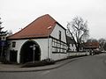
Töpfermühle Möbisburg ( Location → )
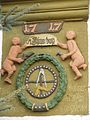
Coat of arms at the gate of the pottery mill
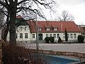
School from 1914

Relief of a pottery workshop at the pottery mill


Population development
- 1843: 572 (Möbisburg: 464, Rhoda: 108)
- 1910: 1016 (Möbisburg: 854, Rhoda: 162)
- 1939: 1344 (Möbisburg: 1092, Rhoda: 252)
- 1990: 1083
- 1995: 1097
- 2000: 1062
- 2005: 1113
- 2010: 1095
- 2015: 1063
Interesting
- The place is traversed by the Gera and has been the city of Erfurt's water supplier since 1898, after the city acquired around 25 hectares of land in 1893 in order to build a waterworks on it.
- In 2006 at the height between Möbisburg, Waltersleben and the federal highway 4 with the "Windpark Möbisburg" 11 very large wind turbines Enercon E 70 were built at a cost of 21 million euros (from loans), which dominate the landscape above the place and the view from the Steigerwald to the Thuringian Forest and its foreland.
- The Möbisburg open-air swimming pool attracts refreshment seekers every summer.
- Möbisburg is on the Gera cycle path and on the extension of the Jakobsweg coming from Görlitz .
- The Evangelical Church of the Good Shepherd in Rhoda was built in 1708 (after Galletti in 1714). The interior was renewed in 1983. The tower on the west side of the small church houses a bell. ( Location → ).
Web links
Individual evidence
- ↑ Michael Köhler: Thuringian castles and fortified prehistoric and early historical living spaces. Jenzig-Verlag, 2001, p. 183, ISBN 3-910141-43-9 .
- ↑ www.mittelhausen.de , accessed on April 5, 2012
- ↑ www.arnobeier.de , accessed on April 5, 2012
- ↑ History of Möbisburger potters mill Accessed 12 May 2012
- ^ Handbook of the Province of Saxony. Magdeburg, 1843.
- ^ Johann Friedrich Kratzsch : Lexicon of all localities of the German federal states . Naumburg, 1843.
- ↑ gemeindeververzeichnis.de
- ↑ Michael Rademacher: German administrative history from the unification of the empire in 1871 to the reunification in 1990. (Online material for the dissertation, Osnabrück 2006).
- ^ Thuringian State Office for Environment and Geology: Environment regional.
- ↑ Population of the city districts
- ↑ http://www.swe-netz.de/swe/cms_de.nsf/%28$UNID%29/823E8A831D1F8B63C12573FD003045FF?OpenDocument
- ↑ http://www.heavy-transport-world.de/index.php?pTemplate=default&pId=525

Districts: Old Town | Andreasvorstadt | Berliner Platz | Brühlervorstadt | Daberstedt | Herrenberg | Hohenzüge | Ilversgehofen | Johannesplatz | Johannesvorstadt | Krmpfervorstadt | Löbervorstadt | Melchendorf | Moscow Square | Rieth | Red Mountain | Meadow hill
Districts: Alach | Azmannsdorf | Bindersleben | Bischleben and Stedten | Büßleben | Dittelstedt | Egstedt | Ermstedt | Frienstedt | Gispersleben | Gottstedt | Hochheim | Hochstedt | Kerspleben | Kühnhausen | Linderbach | Marbach | Mittelhausen | Möbisburg-Rhoda | Molsdorf | Niedernissa | Rohda (Haarberg) | Salomonsborn | Schaderode | Schmira | Schwerborn | Stotternheim | Sulzer settlement | Deep valley | Töttelstädt | Killing life | Urbich | Vieselbach | Wallichen | Waltersleben | Windischholzhausen