
Schaderode
|
Schaderode
State capital Erfurt
Coordinates: 51 ° 0 ′ 32 ″ N , 10 ° 55 ′ 27 ″ E
|
|
|---|---|
| Height : | 292–313 m above sea level NN |
| Area : | 1.42 km² |
| Residents : | 282 (December 31, 2016) |
| Population density : | 199 inhabitants / km² |
| Incorporation : | July 1, 1994 |
| Postal code : | 99090 |
| Area code : | 036208 |
 Location of Schaderode in Erfurt
|
|
Schaderode is a district of the Thuringian capital Erfurt .
geography
Schaderode is about ten kilometers northwest of downtown Erfurt. The landscape is characterized on the one hand by the Thuringian Basin with its extensive arable land and on the other hand by the Schaderroder Grund , in which the Weißbach flows towards the Tiefthal , and the foothills of the Fahner Heights with their forests behind it . Neighboring villages are Friedrichsdorf in the north, Tiefthal in the northeast, Salomonsborn in the southeast, Alach in the south and Töttelstädt in the west.
history
The Rode desert at the site of today's Schaderode belonged to the Counts of Gleichen , who enfeoffed the Erfurt patrician family Brun. In 1497, Rode passed from the property of the Brun family to Asmus Schade , a citizen of Erfurt. Hence the name Schaderode was derived for the gradually repopulated place. Hans Georg Schade zu Döllstädt sold the property on January 13, 1605 to the City Council of Erfurt. The place thus belonged to the area of the city of Erfurt in the following period . Since the administrative reform of 1706 he belonged to the Alach office . In 1802 the place came to Prussia and between 1807 and 1813 to the French Principality of Erfurt . With the Congress of Vienna , the place, which at that time had only a few buildings, came back to Prussia as a district of Alach and in 1816 it was incorporated into the district of Erfurt in the Prussian province of Saxony .
After reunification, the town multiplied its population through the construction of several new streets with suburban single-family houses. In 1994 Schaderode merged with the other districts of the municipality of Alach in the state capital Erfurt.
Population development
- 1995: 247
- 2000: 319
- 2005: 322
- 2010: 290
- 2015: 283
Economy and Transport
Schaderode is a pure place of residence without its own business. Connecting roads lead from Schaderode to Alach in the south and Töttelstädt in the west. The road to Töttelstädt is a purely farm road and not a public road. Thus Schaderode is a " dead end village ". The federal motorway 71 runs directly south of the village, but there is no access to it in this area. The next connection points are Erfurt-Bindersleben and Erfurt-Gispersleben.
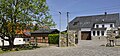
- Impressions


Individual evidence
Web links
- Schaderode on the website of the Erfurt city administration ( Memento from November 9, 2011 in the Internet Archive )

Districts: Old Town | Andreasvorstadt | Berliner Platz | Brühlervorstadt | Daberstedt | Herrenberg | Hohenzüge | Ilversgehofen | Johannesplatz | Johannesvorstadt | Krmpfervorstadt | Löbervorstadt | Melchendorf | Moscow Square | Rieth | Red Mountain | Meadow hill
Districts: Alach | Azmannsdorf | Bindersleben | Bischleben and Stedten | Büßleben | Dittelstedt | Egstedt | Ermstedt | Frienstedt | Gispersleben | Gottstedt | Hochheim | Hochstedt | Kerspleben | Kühnhausen | Linderbach | Marbach | Mittelhausen | Möbisburg-Rhoda | Molsdorf | Niedernissa | Rohda (Haarberg) | Salomonsborn | Schaderode | Schmira | Schwerborn | Stotternheim | Sulzer settlement | Deep valley | Töttelstädt | Killing life | Urbich | Vieselbach | Wallichen | Waltersleben | Windischholzhausen