Pley
|
Pley
City of Würselen
Coordinates: 50 ° 50 '53 " N , 6 ° 5' 53" E
|
|
|---|---|
| Height : | approx. 160 m |
Pley is a north-western district of Würselen in the Aachen city region . To the southeast is the Würselen district of Bardenberg , to the west of the Herzogenrath district of Kohlscheid and to the east of the Herzogenrath district of Niederbardenberg . The Wurm , which forms the city limits there, flows between Pley and Kohlscheid . There is a small sewage treatment plant at the southern exit of the town . There is also a children's playground in the village.
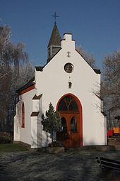
The center of Pley is on the one hand by the mighty Pleyer Poplar determines a 250 year old tree. On the other hand through the chapel of St. Anthony of Padua , which was inaugurated in November 1900 and belongs to the parish of Peter and Paul Church (Bardenberg) .
societies
The local football and athletics club is the "SG Pley 1959 eV".
traffic
The next motorway junctions are "Aachen-Zentrum / Würselen" on the A 4 and "Broichweiden" on the A 44 . The next train station is Herzogenrath train station .
Attractions
- Good cuckum
- Chapel of St. Anthony of Padua
- Pleyer poplar
impressions
Web links
- Brief description under districts of Würselen on the pages of ourac.de
- Pley in the genealogical directory of GenWiki
Individual evidence
- ↑ Chapel Würselen-Pley , short portrait on komoot.de
- ^ SG Pley


