Erfurt city fortifications


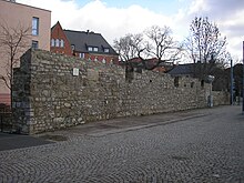
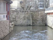
The Erfurt city fortifications were the city fortifications of the city of Erfurt . It existed from 1066 to 1873 and was one of the most extensively developed city fortifications in Germany. The inner and outer ring of walls with towers and gates as well as the Petersberg citadel and the Cyriaksburg citadel belonged to the city fortifications . Except for the two citadels and a few short sections of the wall, nothing of the city fortifications has survived today.
The inner wall ring
The inner wall ring was the oldest part of the Erfurt city fortifications. It was completed in 1066 and was located in the area of today's Yuri Gagarin Ring . At that time Erfurt belonged to the Archdiocese of Mainz , which had the city fortified in order to protect it from the Landgraves of Thuringia . Landgrave Ludwig II had the fortification razed in 1165, but by 1168 its reinforcing reconstruction was completed.
This wall was about eight kilometers long, three to four meters high and about a meter thick. In front of the wall there was a moat , the Wilde Gera . The wall was guarded by around 50 watchtowers.
The demolition of the inner wall began in the first half of the 19th century. All inner city gates were torn down as early as 1842. After the flood ditch was expanded, the Wilde Gera was also filled in. From 1898 a ring road (today's Juri-Gagarin-Ring) was laid out on it.
The outer wall ring
When Erfurt experienced a rapid boom in the 13th century, the area of the city became too small so that it had to be expanded. This expansion took place through the inclusion of new, partly built-up areas with suburbs in the north, east and south of the city as well as the Brühl in a new city fortification. The construction of the outer wall was financed by the introduction of a new tax in the city, the Wallgeld .
In a first step, the new, outer city gates were built between 1350 and 1387 to control traffic in and out of the city. At first they were not yet connected by a wall. This was only gradually built in the following decades until the completion of the outer wall ring in 1480. Later the city gates were also fortified and defensive towers were added, so that at the end of the day 27 towers were available to guard the wall. A moat, the flood ditch, was also created in front of this wall . After the city fortifications were removed, it was significantly expanded for flood protection and still exists today.
During the Thirty Years' War , the city fortifications were again significantly expanded. For this purpose, the Swedish occupiers had some parish churches in Erfurt's old town torn down, and the stones could then be used to strengthen the walls. The citadel Cyriaksburg was created in 1480, the citadel Petersberg in 1665. Later various jumps were added, such as the Daberstedter Schanze (today Stadtpark ) or the Auenschanze in the Andreasvorstadt.
In 1873, like all other fortresses in Germany, Erfurt was de-fortified. In the period that followed, the walls and towers were removed, the flood ditch expanded and the Erfurt city ring laid out in front of the former walls . It was now possible to build in front of the walls, after which the Erfurt suburbs emerged . The Thuringian Railway embankment was built on a southern part of the old wall .
City gates
- Andreastor (inside and outside): at the end of Andreasstraße , in front of it the Nordhäuser Straße to Nordhausen , Braunschweig and Lübeck , named after the Andreaskirche
- Moritztor (inside and outside): at the end of Moritzstraße, in front of it Auenstraße, also city gate, where the Gera leaves the city, named after the Moritzkirche
- Johannestor (inside and outside): at the end of Johannesstraße , in front of it Magdeburger Allee after Sömmerda , Sangerhausen and Magdeburg , named after the Johanneskirche
- Krämpfertor (inside and outside): at the end of Krämpferstrasse, in front of it Leipziger Strasse ( Via regia ) to Leipzig , named after the merchant church
- Schmidtstedter Tor (outside): at the end of Schmidtstedter Straße, in front of it the Weimar Straße to Weimar and Jena , named after the no longer existing village of Schmidtstedt
- Spielbergtor (outside): at the end of Bahnhofstraße, in front of it the Clara-Zetkin-Straße to Kranichfeld and Rudolstadt
- August Gate (inside): in Bahnhofstrasse, named after the Reglerkirche (Augustiniuskirche)
- Löbertor (inside and outside): at the end of Löberstraße, in front of that the Arnstädter Straße to Arnstadt and Nuremberg , named after the tanners who were resident in the adjacent quarter
- Gate (outside): at the end of Dalbergweg, before that Hochheimer Straße to Hochheim and Neudietendorf
- Brühler Tor (inside and outside): at the end of Brühler Straße, in front of it Gothaer Straße (Via regia) to Gotha , Eisenach and Frankfurt am Main , named after the suburb of Brühl
- Lauentor (inside and outside): at the end of the street Lauentor, in front of it the Binderslebener Landstraße to Bindersleben , named after the lion, the heraldic animal of the Count von Gleichen , who was initially bailiff in Erfurt and was initially allowed to use this gate exclusively
literature
Steffen Raßloff : 100 monuments in Erfurt. History and stories. With photographs by Sascha Fromm. Essen 2013. p. 20 f.


