
Sangerhausen
| coat of arms | Germany map | |
|---|---|---|

|
Coordinates: 51 ° 28 ' N , 11 ° 18' E |
|
| Basic data | ||
| State : | Saxony-Anhalt | |
| County : | Mansfeld-Südharz | |
| Height : | 154 m above sea level NHN | |
| Area : | 207.66 km 2 | |
| Residents: | 25,963 (Dec. 31, 2019) | |
| Population density : | 125 inhabitants per km 2 | |
| Postal code : | 06526 | |
| Primaries : | 03464, 034656 , 034658, 034775 | |
| License plate : | MSH, EIL, HET, ML, SGH | |
| Community key : | 15 0 87 370 | |
| LOCODE : | DE SHA | |
| NUTS : | DEE0A | |
| City structure: | 17 districts | |
City administration address : |
Markt 7a 06526 Sangerhausen |
|
| Website : | ||
| Lord Mayor : | Sven Strauss ( SPD ) | |
| Location of the city of Sangerhausen in the district of Mansfeld-Südharz | ||
  |
||

Sangerhausen is the district town of the Mansfeld-Südharz district in the state of Saxony-Anhalt . It is located in the southwest of the state near the border with the Free State of Thuringia .
geography
Geographical location
Sangerhausen is located on the eastern edge of the Golden Aue , a fertile valley between Harz and Kyffhäuser , through which the Helme river flows. The river Gonna flows through the city itself . The nearest large cities are Magdeburg north of the city and Erfurt in the south, as well as Göttingen in the west and Halle (Saale) east of Sangerhausen.
Neighboring communities
Neighboring communities are Harzgerode ( Harz district ) in the north, Südharz in the west, Wallhausen and Edersleben in the south and Allstedt and Mansfeld in the east.
City structure
The 14 localities of the city are:
| Locality | Residents 1 | Incorporation | Districts 2 | The localities of Sangerhausen (clickable map) 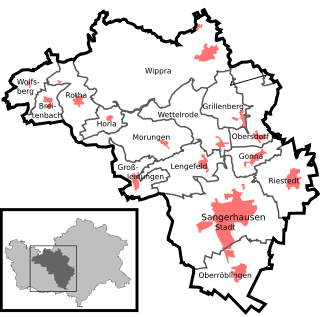  |
|---|---|---|---|---|
| Breitenbach | 215 | 10/01/2005 | Breitenbach (O) | |
| Gonna | 614 | 10/01/2005 | Gonna (O) , Hüttenmühle (M) and Ölmühle (M) | |
| Grillenberg | 274 | 10/01/2005 | Grillenberg (O) and Klippmühle (M) | |
| Large lines | 431 | 10/01/2005 | Large lines (O) | |
| Horla | 105 | 10/01/2005 | Horla (O) | |
| Lengefeld | 624 | 10/01/2005 | Lengefeld, (O) , Meuserlengefeld (O) and Schlösschenkopf (W) | |
| Morungen | 148 | 10/01/2005 | Morungen (O) | |
| Oberröblingen | 1,537 | 10/01/2005 | Rohrbach Monastery (W) and Oberröblingen (O) | |
| Obersdorf | 468 | 10/01/2005 | Obersdorf (O) | |
| Riestedt | 1,294 | 12/01/2005 | Riestedt (O) | |
| Rotha | 275 | 10/01/2005 | Passbruch (O) and Rotha (O) , | |
| Sangerhausen | 18,819 | - |
Districts of the village of Sangerhausen
Beinschuh (W) , Brühl (W) , Brumbach (F) , Engelsburg (W) , Eschental (W) , Helmepark (W) , Im Schlag (W) , Jackenthalmühle (M) , Kupferhütte (W) , Ludwigstrauch (W) , St. Julian (W) , navigation (W) , stud mill (W) , Taubenberg (W) , Walkmühle (W) , wine stock (W) , orphans mill (M) and Wilhelm height (W)
|
|
| Wettelrode | 522 | 10/01/2005 | Wettelrode (O) | |
| Wippra | 1,351 | 01/01/2008 | Schwende bottom (F) , Hayda (O) , Popperode (O) , slate ditch (F) , reservoir (W) , Wild stable (F) and Wippra (O) | |
| Wolfsberg | 117 | 10/01/2005 | Wolfsberg (O) |
.JPG)
1 The population figures refer to February 1, 2020.
2 The districts:
-
O = district (village)
-
W = living space
-
F = forester's house
- M = mill
Pfeiffersheim bei Sangerhausen is no longer listed as a district, but is a street name in the city of Sangerhausen.
To the west of Sangerhausen lies the Kieselhausen desert .
history


middle Ages
Sangerhausen is probably a Franconian foundation. The settlement was mentioned for the first time in a document book of the Fulda monastery drawn up between 780 and 802 . In a register of the tithe of the Hersfeld monastery , which was created between 881 and 899, Sangerhausen is named as a place of tenancy, Sangerhus im Friesenfeld . In 991 the village belonged to the Memleben monastery . From the 10th century there was a Fronhof in the area of today's Ulrich Church. After Sangerhausen was granted market rights between 1004 and 1017, a market town was created in the area of today's Old Market . This grew together with the Frohnhof in the north due to the influx of merchants. In 1194 the village was granted town charter. In 1204 the current city was protected by a palisade fence, in 1263 it received a city wall and in 1485 it fell to the Albertine line of the Wettins . Important industry had since the Middle Ages, the silver and copper - mining . In 1391 groschengeld was minted for the first time in the history of Meissnian groschen outside the state mint in Freiberg in the newly established mint in Sangerhausen . The new coin was built for payment obligations in the Harz silver mining.
Since many citizens of Sangerhausen took part in the Peasants' War in 1525 , the city was punished with 5,000 guilders and seven executions . It was only after the death of Duke George the Bearded in 1539 that the Reformation prevailed.
Modern times
Witch persecutions took place in Sangerhausen between 1536 and 1710 . 22 people, 17 women and five men, got into witch trials . At least three women were cremated, one woman and three men beheaded, and two women died under torture. Jutte Stulzingk was burned as the first victim in 1536. Similar trials took place in the district of Grillenberg between 1607 and 1614: a woman accused of being a witch was burned, another expelled from the country.
The importance of mining gradually declined by the 19th century. In 1815 Sangerhausen became Prussian and the administrative seat of the district of Sangerhausen in the administrative district of Merseburg in the province of Saxony . The connection to the railway network took place on July 10, 1866 through the Halle – Hann railway line. Münden . In 1880 the railway line to Erfurt was added. The industrialization led to the establishment of factories that filing, bicycles, malt, pianos , machinery , furniture , leather, cheese and sugar manufactured. In 1903 the Rosarium was founded in the east of the city.
→ Main article: Air raids on Sangerhausen
During the Second World War , Sangerhausen suffered several US air raids , the main target of which was the station. On February 22, 1945 an attack by 11 heavy bombers of the type B-24 "Liberator" with 23.5 tons of high explosive bombs took place on the station, gas works and town. From 7th to 11th April 1945 the station area was the target of deep attacks by fighter-bombers every day . The main station building was destroyed on April 7, 1945 when a loaded ammunition train was detonated. A total of 87 people lost their lives in the air raids on Sangerhausen.
On April 12, 1945 the city was occupied by the US Army and on July 3 by the Red Army . This made it part of the Soviet occupation zone and, from 1949, of the GDR.
Already during the Second World War, explorations were made to resume mining. In 1951, with the VEB Thomas-Münzer-Schacht , the mining of copper ore began again , but this had to be stopped after the reunification , as the production costs exceeded the world market price by more than ten times. Witnesses of the former mining are the museum shaft Wettelrode and the huge waste dump (called Schachhalde Hohe Linde) in the north of the city.
During the GDR era, the Ministry for State Security had a district office in Mogkstrasse.
During the Peaceful Revolution in 1989/90 a round table was formed and demonstrations with up to 25,000 participants took place.
Incorporations
On October 1, 2005, the Sangerhausen administrative community was dissolved, and its member communities Gonna , Grillenberg , Horla , Lengefeld , Morungen , Oberröblingen , Obersdorf , Rotha and Wettelrode as well as the communities Breitenbach , Großleinungen and Wolfsberg from the Roßla-Südharz administrative community became the town of Sangerhausen incorporated. On December 1, 2005, the municipality of Riestedt followed from the Allstedt-Kaltenborn administrative community and on January 1, 2008, the Wippra municipality was incorporated into Sangerhausen from the Wipper-Eine administrative community .
Population development
Development of the population:


|
|
* Incorporation of surrounding villages, excluding the municipality of Wippra, which was incorporated on January 1, 2008
** Population of Sangerhausen (city) in brackets
politics
City council
The five-year city council has been made up of 36 members and the mayor (Sven Strauss, SPD) since the election on May 26, 2019. The chairman of the city council is Andreas Skrypek (CDU). The current electoral term lasts from July 1, 2019 to June 30, 2024.
| year | CDU | LEFT | BOS | TO | SPD | FDP | Green | AfD | More seats | total |
|---|---|---|---|---|---|---|---|---|---|---|
| 2019 | 8th | 5 | 3 | 4th | 4th | 2 | 1 | 7th | 1: BV, 1: EB | 36 |
| 2014 | 9 | 9 | 6th | 5 | 3 | 2 | 1 | 0 | 1: FBM / WGF / SGH | 36 |
| 2009 | 10 | 10 | 7th | 6th | 4th | 2 | 0 | 0 | 1: NPD | 40 |
- BOS: Citizens' initiative for the districts of Sangerhausen
- BIS: Citizens' Initiative Sangerhausen eV.
- BV: Farmers' Association
coat of arms
Blazon : “In blue two diagonally crossed silver double hooks looped through by a golden 'S'; the hook tips laterally facing each other. "
The city's colors are blue and white.
Town twinning
Sangerhausen maintains city partnerships with the Hessian Baunatal , the Slovak city Trnava and with the Polish Zabrze (also known as Hindenburg OS).
Culture and sights
There are three medieval churches in the city : the market church of St. Jakobi , St. Ulrici (a Romanesque pillar basilica in the core) and St. Mary's Church. Some secular buildings such as the old castle (only remnants), the new castle (seat of the district court ) or the old town hall date from the Middle Ages. The medieval city center with its town houses from the Renaissance period is also worth seeing .

Ulrich Church (Sankt Ulrici)

Church tower of the St. Jakobi market church
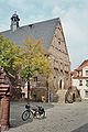
Old town hall , built around 1550
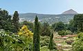
Rosarium in Sangerhausen


There has been a New Apostolic Church since 1907 . The neo-Gothic, Catholic Sacred Heart Church was consecrated in 1894.
The Rosarium has been located in Sangerhausen since 1903, known as the Europa Rosarium since 1993 , with the largest collection of roses in the world. It belongs to the Network Garden Dreams Saxony-Anhalt . The Spengler Museum has the complete skeleton of an old mammoth .
→ See also St. Katharina's monastery ruins
Sports
Important sports clubs in the city are VfB Sangerhausen and ASV 1902 Sangerhausen . In 2005 Mike and Steve Pfaffenberger (RSV Sangerhausen) became world champions in the two-man bike ball .
Economy and Infrastructure
economy
The region around Sangerhausen is one of the economically weakest in Germany. With the decline of mining after 1990, the main livelihood for the people of the area ceased. Currently (as of March 2019) the unemployment rate is 10.0 percent. Nevertheless, some traditional companies such as MIFA Mitteldeutsche Fahrradwerke were able to survive and assert themselves in the market. GMT Gummi-Metall-Technik GmbH in Baden has had a production site in Sangerhausen since 2019 .
Transport links

The new A 38 ( Leipzig / Halle– Göttingen / Kassel ) runs south of the city as the most important long-distance connection . The A 71 begins at the "Südharz" triangle near Sangerhausen via Erfurt to Schweinfurt . The Sangerhausen-West (15) and Sangerhausen-Süd (16) junctions are located on the A 38. The continuation of the A 71 north to Plötzkau to the A 14 is to be included in the 2015 Federal Transport Infrastructure Plan.
The B 80 from Halle to Nordhausen, which was downgraded in 2007 in the area from Sangerhausen to the state road, ran through Sangerhausen . The B 86 also runs from Erfurt to Hettstedt on a bypass . Other roads connect the city with Bad Frankenhausen in the southwest, Oberröblingen in the south (old B 86), Othal in the east, Wippra in the north and Lengefeld and Wettelrode in the northwest.
The Halle – Hann railway lines intersect at Sangerhausen station . Münden and Magdeburg – Erfurt, for the latter, the Sangerhausen – Erfurt line meets here from the south with the section of the Berlin – Blankenheim line from the north, with continuous connections every two hours. There are also hourly connections to Halle and Nordhausen with the so-called “ Copper Express ”.
health
One of the largest employers in the city of Sangerhausen is the Helios Clinic . It serves as the academic teaching hospital of the Martin Luther University Halle-Wittenberg . According to Section 3 of the State Hospital Act, the clinic is responsible for basic care .
Personalities
Others
The asteroid "9819 Sangerhausen", first discovered by the Palomar observatory on March 25, 1971, was named after the town of Sangerhausen.
literature
- Friedrich Schmidt: History of the city of Sangerhausen in two parts. Magistrate of the City of Sangerhausen, Sangerhausen, 1906
- Monika Frohriep: Sangerhausen . Sutton Verlag, Erfurt 2004, ISBN 3-89702-706-2 .
- Hartmut Müller: Time leaps in Sangerhausen . Sutton Verlag, Erfurt 2008, ISBN 978-3-86680-272-8 .
- Thilo Ziegler : Under the swastika. An outline of the history of the Sangerhausen district from 1933 to 1945 . Sondershausen, 2004
Web links
- Website of the city of Sangerhausen
- Internet presence of Rosenstadt Sangerhausen GmbH, Society for Culture, Tourism & Marketing
- Historical photographs (1914) / Sammlg. Bernd Nasner
Individual evidence
- ↑ State Statistical Office Saxony-Anhalt, population of the municipalities - as of December 31, 2019 (PDF) (update) ( help ).
- ↑ http://www.sangerhausen.de/ortsteile districts of the city of Sangerhausen
- ↑ Manfred Wilde, The sorcery and witch trials in Saxony . Cologne, Weimar, Vienna 2003, pp. 562–568; Ronald Füssel: The witch hunts in the Thuringian area . Publications of the working group for historical witchcraft and crime research in Northern Germany, Volume 2, Hamburg 2003, p. 250. Benedict Carpzov: Practica Nova Imperialis Saxonica Rerum Criminalium . in partes 3 diuisa autore Bededicto Carpzovio, Frankofurti et Wittebergae 1652, at the end of part 1., p. 338, p. 341
- ↑ Thilo Ziegler: In search of traces. The Sangerhausen district from 1939 to 1945 . Sangerhausen 1999. p. 126
- ↑ http://www.mz-web.de/sangerhausen/juengste-geschichte-plastisch-8769640
- ↑ StBA: Changes in the municipalities in Germany, see 2005
- ↑ StBA Area: changes from 01.01. until December 31, 2008
- ↑ census database
- ↑ State Statistical Office Saxony-Anhalt: Election results for the 2019 municipal council elections (online) , accessed on October 16, 2019.
- ↑ Archived copy ( Memento of the original from May 27, 2014 in the Internet Archive ) Info: The archive link was inserted automatically and has not yet been checked. Please check the original and archive link according to the instructions and then remove this notice. .
- ↑ City Council ( Memento from October 17, 2013 in the Internet Archive ) www.stadt.sangerhausen.de. Retrieved December 12, 2011.
- ^ City of Sangerhausen: City Council Election 2019 , accessed on October 16, 2019.
- ^ Sangerhausen, Employment Agency statistik.arbeitsagentur.de
Ahlsdorf | Allstedt | Arnstein | Benndorf | Berga | Blankenheim | Bornstedt | Bridge minced puffle | Edersleben | Gerbstedt | Helbra | Hergisdorf | Hettstedt | Kelbra (Kyffhäuser) | Klostermansfeld | Lutherstadt Eisleben | Mansfeld | Sangerhausen | Lake Mansfelder Land | South Harz | Wallhausen | Wimmelburg