
Mansfelder Land lake area
| coat of arms | Germany map | |
|---|---|---|

|
Coordinates: 51 ° 28 ' N , 11 ° 41' E |
|
| Basic data | ||
| State : | Saxony-Anhalt | |
| County : | Mansfeld-Südharz | |
| Height : | 95 m above sea level NHN | |
| Area : | 107.92 km 2 | |
| Residents: | 8880 (Dec. 31, 2019) | |
| Population density : | 82 inhabitants per km 2 | |
| Postal code : | 06317 | |
| Primaries : | 034776, 034774, 034601 (Amsdorf, Wansleben am See), 034773 (Dederstedt, Neehausen), 03475 (Lüttchendorf, Neehausen) | |
| License plate : | MSH, EIL, HET, ML, SGH | |
| Community key : | 15 0 87 386 | |
| Community structure: | 15 districts | |
| Address of the municipal administration: |
Pfarrstrasse 8 06317 Mansfelder Land lake area |
|
| Website : | ||
| Mayor : | Jürgen Ludwig | |
| Location of the community Seegebiet Mansfelder Land in the district of Mansfeld-Südharz | ||
  |
||

Lake Mansfelder Land is a municipality in the district of Mansfeld-Südharz in Saxony-Anhalt .
geography
Lake Mansfelder Land is located in the eastern district of Mansfeld-Südharz between Halle (Saale) and Lutherstadt Eisleben . The community lies partly on the agriculturally used Mansfelder Platte and the Eisleben lowland , which is rich in lakes , and here is the four-kilometer-long Sweet Lake . In the west the area rises to the wooded Harz foothills Hornburger Sattel . Germany's northernmost wine-growing region is located on the Riss mountain slope between Wormsleben and Seeburg .
Neighboring communities
Neighboring communities are Lutherstadt Eisleben in the west, Gerbstedt in the north, Salzatal and Teutschenthal in the east and Obhausen , Schraplau , Farnstädt and Querfurt in the south.
Districts
| Locality | Residents | Districts |
  Mansfelder Land lake area (clickable map) |
|---|---|---|---|
| Amsdorf | 491 | Amsdorf | |
| Aselife | 521 | Aselife | |
| Erdeborn | 1029 | Erdeborn | |
| Dederstedt | 425 | Dederstedt | |
| Hornburg | 341 | Hornburg, abbot and wood cell | |
| Lüttchendorf | 622 | Lüttchendorf and Wormsleben | |
| Neehausen | 261 | Elbitz, Neehausen and Volkmaritz | |
| Röblingen am See | 3002 | New settlement, Oberröblingen and Unterröblingen | |
| Seeburg | 576 | Seeburg and Rollsdorf | |
| Stedten | 1005 | Stedten | |
| Wansleben am See | 1741 | Wansleben |
The population figures refer to December 31, 2008
history
The community was created on January 1, 2010 through the merger of the communities Amsdorf , Aseleben , Erdeborn , Hornburg , Lüttchendorf , Neehausen , Röblingen am See , Seeburg , Stedten and Wansleben am See with the background of the municipal reform in Saxony-Anhalt. When it came into being, the administrative community for the sea area Mansfelder Land was dissolved. The community of Dederstedt , which rejected the incorporation, was compulsorily incorporated into the Mansfelder Land lake area by law on September 1, 2010.
religion
8% of the population are Protestant, 3% Catholic.
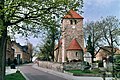
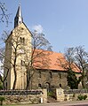
The Lutheran churches Amsdorf, Erdeborn, Röblingen, Stedten and Wansleben form the Parish Röblingen; the parishes of Dederstedt, Neehausen and Volkmaritz belong to the parish of Dederstedt- Hedersleben . The churches in Aseleben, Rollsdorf and Seeburg are combined to form the parish of Seeburg, the churches in Lüttchendorf and Wormsleben to form the parish of Lüttchendorf-Wormsleben. All of these parishes and parishes belong to the Eisleben-Sömmerda parish of the Evangelical Church in Central Germany .
Amsdorf

Aselife

Dederstedt
Erdeborn

Lüttchendorf

Neehausen
Röblingen

Rollsdorf

Seeburg

Stedten

Volkmaritz

Wansleben

Wormsleben
,_the_village_church-2.jpg)

,_die_Dorfkirche.jpg)
,_the_village_church.jpg)


The Catholic branch church St. Anna in Röblingen belongs to the parish of St. Bruno in Querfurt . The village of Hornburg is, however, assigned to the parish of St. Gertrud in Eisleben , whose next branch church is St. Maria in Sittichenbach . Both parishes belong to the Merseburg deanery of the Magdeburg diocese .
politics
Municipal council
After the 2014 local elections, the council has 20 members.
- Christian Democratic Union of Germany / CDU: 8 seats
- DIE LINKE: 4 seats
- Social Democratic Party of Germany: 2 seats
- Free citizens Central Germany Sea area Mansfelder Land: 1 seat
- Independent citizen movement Mansfelder Land: 2 seats
- Voluntary fire brigade Mansfelder Land lake area: 1 seat
- Alliance for clubs: 1 seat
- Citizens' list of the Sweet Lake: 1 seat
coat of arms
The coat of arms was approved by the district on February 10, 2010.
Blazon : “Half split and divided; black mallets and iron crossed in gold at the top, three golden ears of wheat in black at the top, a silver fish at the bottom in blue. "
The colors of the parish are blue - yellow.
flag
The flag is blue-yellow (1: 1) striped (horizontal shape: stripes running horizontally, lengthways shape: stripes running vertically) and centered with the municipal coat of arms.
traffic

The federal highway 80 ( Nordhausen - Halle (Saale) ) and the railway line Halle - Hann. Münden cross the community from west to east.
Industrial history
In 1909, in the Oberröblingen district of Röblingen am See, the sinking of a pit for potash salts of the former " Oberröblingen Union " began. The Adler-Kaliwerke owned 995 of the 1000 kuxes of this mining union. After completion of the Oberröblingen shaft, an underground connection was to be established from it to the neighboring Adler mine . Thus, both pits would have had a "second exit". However, due to the uncontrollable inflow of saline solution, the Oberröblingen shaft finally had to be abandoned in 1913 at a depth of at least 642 m.
Not far from the village of Wansleben am See is the disused potash plant United Ernsthall . It was a mine with an attached potash factory of the "Mansfeldsche Kupferschieferbauenden union".
Individual evidence
- ↑ State Statistical Office Saxony-Anhalt, population of the municipalities - as of December 31, 2019 (PDF) (update) ( help ).
- ↑ a b StBA: Area changes from January 1st to December 31st, 2010
- ↑ census database
- ↑ http://www.seegebiet-mansfelder-land.de/daten/angebote/id/773,1166/Sonderausgabe_11.06.2014.pdf
- ↑ a b Official Gazette of the District No. 2/2010 page 22 ( Memento of the original from February 14, 2015 in the Internet Archive ) Info: The archive link was inserted automatically and has not yet been checked. Please check the original and archive link according to the instructions and then remove this notice. (PDF; 3.0 MB)
Web links
Ahlsdorf | Allstedt | Arnstein | Benndorf | Berga | Blankenheim | Bornstedt | Bridge minced puffle | Edersleben | Gerbstedt | Helbra | Hergisdorf | Hettstedt | Kelbra (Kyffhäuser) | Klostermansfeld | Lutherstadt Eisleben | Mansfeld | Sangerhausen | Lake Mansfelder Land | South Harz | Wallhausen | Wimmelburg