
Adler potash mine
| Adler potash plant | |||
|---|---|---|---|
| General information about the mine | |||
 |
|||
| other names | Adler Kaliwerke AG | ||
| Mining technology | Chamber construction | ||
| Information about the mining company | |||
| Start of operation | 1909 | ||
| End of operation | 1925 | ||
| Successor use | no | ||
| Funded raw materials | |||
| Degradation of | Potash salt | ||
| Mightiness | up to approx. 7 m | ||
| Greatest depth | 596 m | ||
| Geographical location | |||
| Coordinates | 51 ° 27 '59 " N , 11 ° 39' 4" E | ||
|
|||
| Location | Röblingen am See | ||
| local community | Mansfelder Land lake area | ||
| District ( NUTS3 ) | Mansfeld-Südharz | ||
| country | State of Saxony-Anhalt | ||
| Country | Germany | ||
| District | Saale-Unstrut | ||

The Adler potash mine was a potash mine for potash salts with an attached fertilizer factory of the former Adler-Kaliwerke AG near Röblingen in the district of Mansfelder Land in Saxony-Anhalt . Company foundation: June 14, 1905, start of sinking: June 11, 1906, start of production: May 1909, cessation of operations: 1926, in accordance with the decommissioning ordinance of July 18, 1919. The mine field does not support any local situation. The few residential buildings near the shaft are mostly in the area of the shaft safety pier .
Geological and hydrogeological reservoir conditions
Geological and geological assessment
|
Depth (noun) |
rock |
|---|---|
| 0.0 | Surface of the earth |
| 0.3 | Topsoil |
| 24.5 | gray and white sand |
| 27.0 | Swimming sand with lignite deposits |
| 30.0 | clayey sand |
| 37.5 | gray Latvians |
| 39.5 | Lignite quartzite |
| 49.0 | White sand |
| 67.5 | red and white sandstone alternating with Latvians |
| 96.0 | red and blue Latvians with sandstone inclusions |
| 100.5 | solid gray sandstone |
| 204.0 | red and blue Latvians |
| 284.0 | red sandy Latvians |
| 401.0 | red and blue Latvians alternating with sandstone and plaster |
| 423.5 | mostly red Latvians |
| 440.0 | Younger white rock salt |
| 452.0 | red salt tone |
| 511.0 | Younger red rock salt |
| 567.0 | Main anhydrite |
| 577.0 | gray salt tone |
| 582.0 | red and gray-white carnallite |
| 596.0 | Older white rock salt (= final depth) |
The shaft and the mine workings lie on the southern flank of the Teutschenthaler saddle and on the northern edge of the Querfurt Mulde. The mined parts of the deposit consisted of hard salt and mainly carnallitite . The incidence of the bearing is different and lies between about 20 ° and 25 °. To the north of the shaft, the saline at the Teutschenthaler Sattel has largely been depleted as a result of the elevation of the saddle axis towards the northwest.
A number of OT wells were drilled in the vicinity of the Adler shaft for a large-scale exploration of the Flöz “Staßfurt” potash deposit. The in approx. 1.7 km from the Unterröblingen OT borehole, in addition to leaching residues from Zechstein 4 and 3, only the Staßfurt rock salt shows that the horizon is intact. In the OT well Oberröblingen further to the west, the Zechstein 4 was also attacked, while in the OT well Oberröblingen to the south, the Zechstein is still completely present in the OT wells Oberröblingen II, III and IV and in the Oberröblingen shaft . After the deepest of the trough (boreholes Stedten 1 and 2, Schrapplau 1, 3, 4, 5), the thickness of the overburden increases continuously (the presence of shell limestone and the increasing thickness of the red sandstone ).
The boreholes Erdeborn I and Erdeborn III only encountered the main anhydrite undecomposed under gypsum residues from Zechstein 4 and 3 ; they were brought down to the Staßfurt rock salt. In the Erdeborn I and II bores, the gypsum lies directly above the Staßfurt rock salt, the hanging Zechstein layers are missing. BLEI / JUNG regards the gypsum that appears above the Staßfurt rock salt as a facial representation of the potash store (Sangerhauser anhydrite) - i.e. not as a residue formation caused by leaching. In the first “Plant Assessment” from 1911, the deposit was characterized as “shallow”; the thickness given as 6 - 7 m. Furthermore, a local hard salt line encountered was mentioned to a small extent. A value of 9.8% K 2 O was given for the calculated carnallitite reserves and a value of 17.5% for the hard salt. In a later “addendum to reassessment” it was found that the K 2 O content of the stocks had risen to 10.7% (average of 6 samples, tolerances between 8.4 and 11.0%). The deposit thickness was 13.9 m. As a result of a visit to the potash testing center , the K 2 O content was estimated at 9.5% according to funding certificates and 8.0% according to the factory records. According to LÖFFLER, the thickness of the seam was between 5 m and 20 m. Mention is also made of the sudden transition from Staßfurt rock salt - with the elimination of the transition layers - to the potash store, the latter being present in these cases as kieseritic rubble mercarnallite.
While mainly red-colored carnallitite was found in the western field, the carnallitite in the eastern field was gray in color. Tachhydrite has also been detected. The above-mentioned hard salt deposit was found 65 m from the shaft in the western main conveying line with a thickness of one meter and traced over a striking length of 105 m. The hard salt was low in kieserite, stratified and dark gray to reddish in color; the K 2 O content was between 28.4 and 34.6%. A stronger tectonic influence (dip 20 - 30 ° to the south and partial overturning of the potash seam) was mentioned especially for the western field, in which discordant deposits of Leine rock salt were also observed. It should also be mentioned that in the area of the mine field, near-surface underground mining was also carried out through the Wilhelmine lignite mine [according to FUCHS et.al.].
Hydrogeological information
The original hydrogeological conditions in the area of the construction site of the Adler shaft were significantly disturbed by the immediate leaching of the Zechstein in the area in the Eisleben lowland . The salt mirror area itself northerly from the construction field is (formation of by brisk Auslaugungstätigkeit related deformations and the surface reduction wells frequent occurrence of intense uneven cuts, occurrence sinkholes ) marked. All of these phenomena have a particularly negative effect in the area of the Adler mine because of the immediate vicinity of the Hornburg deep fault and the salt level area. In the area of the leaching sinks - the Erdeborn and Röblingen leaching sinks are in the immediate vicinity of the mining field - there is a near-surface water flow. The waters are usually very saline, the groundwater level shows a steady rise. The actual main aquifer in the area of the Mansfeld Mulde, the middle red sandstone, does not occur in the vicinity of the mining field. The upcoming lower red sandstone is mostly impermeable to water. A water flow occurs in this horizon only in the area of the Rogensteinbanks, favored by their fissures. As a result of the neighboring leaching processes, these waters are mostly saline and show a high degree of hardness.
Differentiating these subsidence caused by the leaching of the Zechstein from those that were caused by the mining activity and later drowning of the construction site at the Adler shaft is likely to be very complicated because of the possible overlapping of the phenomena. There is only sparse documentation on the inflow of water and saline solution during the operating period of the Adler mine. With regard to the shaft sinking, it is only mentioned that water difficulties and floating sand breakthroughs occurred at depths below 39 m . It is not known whether the shaft was still completely dry when it was closed in 1927 and in what period of time the rise in water and salt solutions took place [according to FUCHS et.al.].
The shaft construction
The Adler shaft is located approx. 1.2 km southeast of the Erdeborn location, approx. 1.2 km west of the Oberröblingen district ( Röblingen am See ) and approx. 100 m south of the Halle-Eisleben railway line. It stands on the southern flank of the Teutschenthaler saddle, or on the northern edge of the Querfurter Mulde. The Herzynstreiching Hornburg Deep Fault runs between the villages mentioned above , where the subsalinar subsoil in the SE part (Röblingen area) has sunk by at least 400 m. The Hornburger Deep Fault cuts the Hornburger Sattel, which is about 3 km west of the shaft ; according to v. HOYNINGEN is seen as the main inflow point to the salt level in the area of the former salty lake.
The sinking of the Adler shaft began on June 11, 1906. At the end of January 1907, water difficulties and floating sand breakthroughs were eliminated by concreting. At the beginning of August 1907 the red sandstone was approached at 50.5 m, the rock salt on August 14, 1908 at 424 m and the potash store at 577 m on February 1, 1908. The shaft was sunk using the sinkhole method. The total depth of the shaft is 596.0 m. The soil level is + 102.72 m above sea level. The shaft jacket was expanded with segment rings in the upper 214 m , the rest is in masonry . The shaft was provided with two conveyors and has a diameter of 4.5-5.0 m. A devil report is not available. The clear width of the shaft is only known approximately - it could not be verified due to the massive concrete cover [according to FUCHS et.al.].
Removal and installation, dismantling and relocation processes

The potash seam "Staßfurt" was found at 577 m depth, and in that level (580 m- sole ) by sweeping explored routes. To the east, tunneling was stopped after around 450 meters, as the warehouse is wedged here. In a westerly direction, the mining field reached an extent of around 1.9 km, whereby after around 800 m, major changes in the direction of strike (presumably due to tectonic influences in the wake of the Hornburg Deep Fault) can be inferred from the frequent change in direction of the striking stretches. The excavation field of the "Adler" shaft can be divided into 5 assemblies (see figure above):
1. The assembly east of the shaft:
The excavation and dismantling date from the years 1909–1913. 4 levels or partial levels were driven in a west-east direction. Three quarries lie between the 520 m and 569 m level with an average dip of 20 °, a mining width of 12-22 m and a presumed construction height of 6-7 m. The intermediate pillars are 8 m thick. Between the 569 m level and 551 m level, 9 mines with a width of 11-15 m and a construction height of 6-10 m were dismantled. Here the pillar was 7-10 meters thick. This module suggests a sporadic mining guide include (wedging of the deposit). From the 580 m level were two surfaces , one of which ascended m as a double section with a length of about 350 and 70 respectively. In order to promote the salts were several reel mountains applied between the sublevels. The explosives store was opened directly on the eastern edge of the shaft safety pier.
2. The assembly between the shaft safety pillar, the Oberröblingen borehole and the marrow sheath : In this construction site , 11 mines with very different dimensions, with a presumed construction height of 6 - 7 m and an average collapse of approx. 20 O in the years 1909–1913 were dismantled. The shaft safety pillar is penetrated by 3 levels, 2 connecting stretches and a Haspelberg, the borehole safety pillar by 2 levels.
3. The assembly to the west of the borehole safety pillar : This assembly shows a balanced construction over a striking length of 500 m with excavations approx. 17 m wide, a presumed construction height of 6 - 7 m, a pier thickness of approx. 8 m and a collapse of approx. 20 ° - 25 °. The mines lie between the 606 m level and the weather section above the 551 m level. 9 levels or partial levels were driven in the construction site. These excavations and dismantling were carried out in the years 1918–1920.
4. The subassembly following the third subassembly up to cross passage 10 : This subassembly also has a length of approx. 500 m. The direction of strike changes very much to the southwest. The mines lie between the 606 m level and the 586 m or 593 m level. You have m a width of 20, a presumed height 6-7 meters and a dip of about 20 -25 O . The pillar is 10 m thick. A section of the 628 m level was excavated as a device in this assembly. The dismantling went around in the years 1920-1925.
5. The assembly following the 4th assembly: This assembly has only 2 breakdowns. All other pit areas are floors and stretches in a south-west extension of 250 m and an almost north-south extension of 150 m. All of the sole stretches and mountains have probably been driven up in the carnallite camp section. The "lying stretch 580 m depth" and some cross passages are an exception ; they were probably found in the Staßfurt rock salt. Due to the water ingress in the neighboring Oberröblingen shaft in 1913, which was intended as an extension shaft for weather management , these two shafts were not connected, so that the Adler shaft had to be equipped with a separate weather run.

While in assembly 1 east of the shaft - between the partial levels - independent chambers were created, the rest of the construction site shows the typical multi-storey construction with excavation chambers extending over several partial levels. The connecting figures of the chambers were executed from the underground floor . After creating a corresponding underpass, the salts of the Hohe First were probably extracted and removed. The chambers were then approached again from the next higher partial level. The backfill was probably made in such a way that a corresponding cavity remained open for the extraction of the next ridge salts . The removal of the salts and the conveyance of the backfill took place via reel mountains. Benzene locomotives were used to transport the route. The old main production line (580 m depth) penetrated the safety pillar of the Oberröblingen 2 borehole on the south side. This stretch showed strong pressure effects in the area of the safety pillar and had to be abandoned. Before that, a new line was driven in the lying area (Staßfurt-Steinsalz), it is located north of the Oberröblingen 2 borehole. The double line that falls is also to be mentioned, it was started by the building group east of the shaft. The distance is about 350 m long and has a dip 15-22 O . There are no reports on this information either. However, it is likely that it is to be regarded as the starting point of the planned connection route to the “Union Oberröblingen” shaft.
Offset u. Void balance: It can be assumed that the backfill was also supplied with the salts from the horizontal stretches and crosscuts. According to the picture of the pit (see figure above), the dismantling is shown as "staggered" with the date. The uppermost chamber driveways or the last tees of the Hohe Firsten have probably remained open. Parts of the assembly line to the east of the shaft also have offset symbols; they are located roughly below the railway line. A cavity balance sheet was drawn up from the present pit diagram:
Then the following cavities result:
- Sole sections, mountains and cross passages, together approx. 210,000 m 3
- Extraction chamber: approx. 40,000 m 3 x)
Total approx. 250,000 m 3
x) The cavity details for the excavation chambers are to be assessed as "very unsafe". In the calculations it was assumed that only the last or top ridge section remained open (h = approx. 6.5 m) and that the parts of the excavation chambers underneath (main part) are fully offset. The pit diagram does not contain any information about the offset height [according to FUCHS et.al.] .
The financial and business situation


The following information could be compiled from the statistical yearbooks of the German lignite, hard coal and potash industry: Board of Directors: Adolf Soa, Mine Director , Oberröblingen am See. Richard Popendiker, Aschersleben. Founding: June 14th, 1905, commercial registration on September 20th, 1905. Founders were the companies Wulkow & Corneisen in Hamburg, Joh. Ohligschläger in Aachen, Gebr. Röchling in Saarbrücken and the international drilling company in Erkelenz. Purpose of the company: Extraction and utilization of mining products in raw and processed form, especially of potash salts. Share capital: Originally 3,250,000 marks . Changes and share swaps were resolved at several general meetings . The ordinary general assembly on June 8, 1921 resolved to increase the company's operating resources by increasing the share capital by 4,064,000 M (Mark), issuing new ordinary shares and new 6% preference shares valued at M 2 million. Ultimately, a resolution was held in October 1922 General meeting to increase the share capital by a further 6 million M ordinary shares. The net assets of the Company amounted loud Reichsmark - opening balance 5,084,221 RM (Reichsmark). At a further Ordinary General Meeting, it was decided to reduce the paper mark ordinary share capital in the amount of 18 million PM ( paper mark ) in a ratio of 4: 1 to 4.5 million RM and the paper mark preference share capital from 4 million PM to 296,000 RM with additional payment. Accordingly, after the Reichsmark capital conversion on January 1, 1924, the ordinary share capital was RM 4.5 million and the preferred share capital was RM 296,000. Participations: The company owned 995 Kuxe of the union Oberröblingen and 773 Kuxe of the union Hope in Gotha. The latter company in turn owned more than ¾ of the share capital of Kaliwerke Adolfsglück AG. Potash Syndicate : A provisional agreement was reached with the former syndicate in March 1909, so that the dispatch of products manufactured in the company's own factory could begin on March 18, 1909. The company then entered into a provisional bond with the syndicate at the end of June 1909, according to which it was guaranteed a minimum quota of 13.5 thousandths in the case of recognition as a Carnallite plant and of 14.5 thousandths in the case of recognition as a hard salt plant. The factory had belonged to the syndicate since 1909. Righteous : The company Wulkow & Cornelsen inferred into the company for 2.25 million M an area of interest opened up by the "International Drilling Company", secured by 8 salt suspensions in the districts of Erdeborn, Unterröblingen, Oberröblingen, Alberstedt , Schraplau, Unterfarnstedt, Stedten, Oberesperstedt , Unteresperstedt, Amsdorf and Kuckenburg . Together were the 10 fields with a total area of 21.89 Mill.m 2 . The area of interest was west of Halle / Saale, southeast of the Hornburger Saddle, separating the Wansleben potash pit and fields of the protective drilling association of the Ernsthall potash plant ( United Ernsthall potash plant ) (both belonging to the Mansfeld'chen copper slate building union), the Salzmünde potash plant union , the Prussian Treasury and the Krügershall Aktiengesellschaft (with the Krügershall Teutschenthal potash plant ). In the north was the natural border of the area of the former "Salty Lake". The boreholes Oberröblingen I (set in rock salt at depth 690.95 m), Oberröblingen II (set in rock salt at depth 631.0 m), Oberröblingen III (set in rock salt at depth 349.05 m), Oberröblingen IV (set in Rock salt at depth 567.32 m), Erdeborn I (set in rock salt at depth 265.58 m), Erdeborn II (set in rock salt at depth 262.15 m), Erdeborn III (set in rock salt at depth 262.15 m) , Alberstedt (rock salt / potash reached at 811.95 m; set in rock salt at depth 1,056.35 m) and the Schafsee I to III boreholes were all stopped in rock salt up to the point of speculation. The Erdeborn III wells showed the potash deposit from depth 473.25-518.25 m (45.0 m), Oberröblingen II from depth 563.35-571, 80 m (5.45 m), Oberröblingen I from depth 603.25 - 613.65 m (10.40 m), Oberröblingen IV from depth 514.70 m - 517.32 m (2.62 m) and Alberstedt from depth 952.50 - 968.50 m (16 m) to. The ordinary shareholders' meeting of December 18, 1925 resolved to shut down the plant in accordance with the Decommissioning Ordinance of July 18, 1919, Section 83a, until December 31, 1953. In response to its voluntary application for closure, the potash inspection agency granted the plant a participation rate of 83% of the average in 1927 Participation of all potash plants. In 1936 the assets of the four companies forming the Adler Group (Adler-Kaliwerke AG, Bergwerksgesellschaft Hope mbH, Kaliwerke Adolfs Glück AG and Oberröblingen Union) were transferred to the main shareholder, Kaliwerke Aschersleben AG (see also the history of the companies in the city of Aschersleben ) , transfer.
Current condition (2004)
The last addition to the picture of the pit is dated July 28, 1927. The title page also bears the note "The shaft was closed with a concrete cover in April 1927". Earlier examinations of the shaft tube and the water or salt solutions in it gave reliable indications of damage in the shaft lining as well as leaks in the segment lining. In 1978 the solution level in the shaft tube was measured at a depth of 400 m. Compared to the last sounding in 1970, this was an increase of approx. 114 m. Waste material was already at a depth of approx. 450 m recorded. In order to prevent further subrosive activities, the manhole was refilled in 1990 and the manhole cover replaced. Further subsidence above the mining field due to leaching processes in the saline layers is possible. It is difficult to make a statement about the technogenic subrosion processes that are still to be expected, as the mining field itself is located in the area of the so-called Erdeborn subsidence trough, which is characterized by natural subrosion .
After 1945 and until December 31, 1951, the "Deutschland" Teutschenthal potash plant was responsible for the maintenance and control of the cover. From January 1, 1952 to August 1, 1953, the "Geological Commission" was responsible for the shafts. After that, the "Germany" plant again took on the control obligation. The actual shaft also includes a property area of 81 m 2 (Gem. Röblingen, corridor 2, parcel 29); the area includes the manhole cover and the fence. Since the GDR's safekeeping order of October 10, 1971 (GDR GBl. II No. 73), the council of the Halle district has been responsible for a large number of old potash pits, so-called “pits of old mining without legal successors ”. With the accession of the GDR to the area of application of the Basic Law, the Adler mine was regarded as a "decommissioned facility of a mining operation for which a legal successor does not exist or can no longer be determined". In place of the councils of the districts, the respective state governments acted until the relevant regulatory authority regulations were issued (for the state of Saxony-Anhalt : Law on Public Safety and Order of the State of Saxony-Anhalt (SOG LSA) in the version published on 23 September 2003 ( GVBl. LSA p. 214), last amended on May 18, 2010 (GVBl. LSA p. 340)). Thus, up to now, the Adler mine is the responsibility of the municipality with regard to the duty of care for the purpose of averting danger. These and many other potash and rock salt mines that were closed at the time require continuous monitoring.
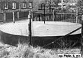
Shaft cover of the old Adler potash shaft from 1978
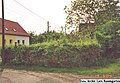
Shaft cover of the old Adler potash shaft in 2004

Shaft cover of the old Adler potash shaft from 1978


swell
- FUCHS, GÖTZE, BAUER: Analysis of mining damage for the “Adler” shaft in Röblingen am See, Teutschenthal, in July 1970, archive of the LAGB Saxony-Anhalt.
- Ministerial Journal for the State of Saxony-Anhalt No. 5/1997.
- MOSSNER, J. (editor): Handbook of the potash mines, salt pans and deep drilling companies, Finanz-Verlag Berlin, 1936.
- PINZKE, G .: Expertise on the assessment of the mining and public safety of selected potash pits without legal successors on the territory of the Halle district. Expert opinion, Council of the District of Schwerin, Department of Geology 1979, archive of the LAGB Saxony-Anhalt.
- O.V .: Yearbooks of the German lignite, hard coal and potash industry, Wilhelm Knapp's publishing house in Halle / Saale.
literature
- Blei, Jung: About the anomalous Zechstein profiles in the area of the Mansfeld Mulde . Freiberg Research Booklet C 133, Bergakademie Freiberg, 1962.
- Löffler: The Zechstein potash and rock salt deposits in the GDR , Part III Saxony-Anhalt. Freiberg research booklet C 97 / III, Bergakademie Freiberg, 1962.
- v. Hoyningen: Salt tectonics and leaching in the area of the Mansfeld Lakes . Freiberg research booklet C 56, Bergakademie Freiberg, 1959.
Web links
- http://www.guenter.pinzke.de/bergbau/galerie2.html
- Adler - Kali. Retrieved on May 4, 2013 (website for the Adler-Kaliwerke AG connecting railway).