Salzatal
| coat of arms | Germany map | |
|---|---|---|

|
Coordinates: 51 ° 32 ' N , 11 ° 46' E |
|
| Basic data | ||
| State : | Saxony-Anhalt | |
| County : | Saalekreis | |
| Height : | 123 m above sea level NHN | |
| Area : | 109.38 km 2 | |
| Residents: | 11,412 (Dec. 31, 2019) | |
| Population density : | 104 inhabitants per km 2 | |
| Postal code : | 06198 | |
| Primaries : | 0345, 034601, 034607, 034609, 034773 | |
| License plate : | SK, MER, MQ, QFT | |
| Community key : | 15 0 88 319 | |
| Community structure: | 21 districts | |
| Association administration address: | Street of the unit 12a 06198 Salzatal, OT Salzmünde |
|
| Website : | ||
| Mayoress : | Ina Zimmermann ( CDU ) | |
| Location of the municipality of Salzatal in the Saale district | ||
Salzatal is a unified municipality in the Saalekreis in Saxony-Anhalt .
geography
Salzatal is located in the north-western part of the Saalekreis and borders the city of Halle to the west. The community was created on January 1, 2010 from the communities Beesenstedt , Bennstedt , Fienstedt , Höhnstedt , Kloschwitz , Lieskau , Salzmünde , Schochwitz and Zappendorf , which belonged to the dissolved administrative community Westlicher Saalkreis .
The official name was derived from the landscape protection area of the same name , which extends over large parts of the unified municipality. The name-giving river Salza flows through the community from south to north and flows into the Saale at Salzmünde . The Saale almost continuously forms the northeastern municipal boundary.
Neighboring communities
Neighboring communities are Wettin-Löbejün in the north, the independent city of Halle (Saale) in the east, Teutschenthal in the south and the sea area of Mansfelder Land and Gerbstedt (both districts of Mansfeld-Südharz ) in the west.
Community structure
The unified municipality of Salzatal consists of the following localities:
| Locality | Residents | Districts |
The villages of Salzatal (clickable map) |
|---|---|---|---|
| Beesenstedt | 1260 | Beesenstedt, Naundorf, Schwittersdorf and Zörnitz | |
| Bennstedt | 1558 | Bennstedt | |
| Fienstedt | 239 | Fienstedt | |
| Höhnstedt | 1549 | Höhnstedt | |
| Toilet sweat | 454 | Johannashall, Kloschwitz, Rumpin and Trebitz | |
| Lieskau | 2616 | Lieskau | |
| Salzmünde | 2432 | Benkendorf, Gödewitz, Neuragoczy, Pfützthal, Quillschina, Salzmünde and Schiepzig |
|
| Schochwitz | 1238 | Gorsleben, Krimpe, Schochwitz, Räther and Wils | |
| Zappendorf | 1500 | Köllme , Müllerdorf and Zappendorf |
The population figures refer to December 31, 2008, the date of incorporation was January 1, 2010 for all localities.
politics
In September 2016, Ina Zimmermann (CDU) was elected as the new mayor with 73.9% of the votes; she took office on May 26, 2017. Incumbent Juliane Sperling-Lippmann no longer stood for election.
coat of arms
The coat of arms was approved by the district on May 17, 2010.
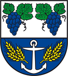
Blazon : "Divided by silver and blue, above two blue grapes with green leaves and black tendrils, below a silver anchor, each accompanied by three fan-like inclined golden ears."
The coat of arms was designed by the municipal heraldist Jörg Mantzsch and included in the approval process. Its symbols anchor-grape-ears were given by resolution of the main statute. While the grapes refer to their cultivation in the region, the anchor expresses the connection to the Saale as an important traffic and trade route. The ears of corn are linked to agriculture as the main food branch of the earlier villages. At its meeting on February 3, 2010, the council of the municipality of Salzatal decided on the coat of arms.
The colors of the municipality are: blue - silver (white).
flag
The flag is blue and white (1: 1) striped (cross shape: stripes running horizontally, lengthways shape: stripes running vertically) and centered with the municipal coat of arms.
Industrial history
About 700 m south of the Trebitz district of Kloschwitz is the disused Johannashall potash mine, owned by the mining union of the same name . It was a mine on potash with an attached fertilizer factory. From 1902 to 1922 the potash seam was mined here to a depth of 542 m.
About 500 m south of the town of Beesenstedt is the also decommissioned potash plant union Wils . The 1,000 Kuxe of this union belonged to the union Johannashall, it was in fact a subsidiary.
Operations began in 1911. After only eleven years of funding, the Wils and Johannashall unions jointly submitted an application to shut down the plants. On September 20, 1926, the trade union meetings resolved to liquidate both unions, and the sale of the entire assets to Kali-Industrie Aktiengesellschaft Berlin, Kassel / Wintershall Aktiengesellschaft, was approved.
Another potash mine, the Salzmünde Potash Works Union, is located on the southwest edge of the village of Zappendorf . Since 1925, this mine has been connected to the pit of the Teutschenthal potash works (formerly Krügershall AG) to the south at the level of the 868 m level, and this in turn with the Angersdorf pit to the east (formerly the Saale potash works and Hallesche Kaliwerke AG) . After the potash production in the Salzmünde shaft was stopped on July 1, 1924, z. B. the shaft tube as an escape and weather shaft for the Krügershall / Teutschenthal mine field for decades.
Web links
Individual evidence
- ↑ State Statistical Office Saxony-Anhalt, population of the municipalities - as of December 31, 2019 (PDF) (update) ( help ).
- ↑ StBA: Area changes from January 01 to December 31, 2010
- ↑ http://www.mz-web.de/saalekreis/buergermeisterwahl-favoritin-gewinnt-die-wahl-25178848
- ↑ Official Journal of the District No. 26/2010 page 2
- ↑ Jörg Mantzsch : The coat of arms of the municipality of Salzatal, documentation on the approval process , deposited with the district of Saalekreis 2010 (expert opinion: State Main Archive Magdeburg)


