Bad Durrenberg
| coat of arms | Germany map | |
|---|---|---|

|
Coordinates: 51 ° 18 ' N , 12 ° 4' E |
|
| Basic data | ||
| State : | Saxony-Anhalt | |
| County : | Saalekreis | |
| Height : | 104 m above sea level NHN | |
| Area : | 36.15 km 2 | |
| Residents: | 11,466 (Dec. 31, 2019) | |
| Population density : | 317 inhabitants per km 2 | |
| Postal code : | 06231 | |
| Area code : | 03462 | |
| License plate : | SK, MER, MQ, QFT | |
| Community key : | 15 0 88 020 | |
| LOCODE : | DE UBG | |
| NUTS : | DEE0B | |
City administration address : |
Hauptstrasse 27 06231 Bad Dürrenberg |
|
| Website : | ||
| Mayor : | Christoph Schulze ( CDU ) | |
| Location of the city of Bad Dürrenberg in the Saale district | ||
The brine town Bad Dürrenberg (until 1935 Dürrenberg ) is a town in the Saalekreis in the state of Saxony-Anhalt .
geography
The brine town of Bad Dürrenberg is located on the Saale between Leipzig , Merseburg and Weißenfels . In the south of the city, the Ellerbach flows into the Saale on the right.
City structure
| Locality | Residents | Districts | |
|---|---|---|---|
| Bad Durrenberg | 10,805 | Bad Dürrenberg, Balditz, Goddula-Vesta, Keuschberg, Kirchfrahtorf, Lennewitz, Ostrau, Porbitz-Poppitz | |
| Nempitz | 293 | Nempitz, Oetzsch and Treben | |
| Oebles-Schlechtewitz | 209 | Oebles-Schlechtewitz | |
| Great joke | 1,175 | Ellerbach, Kauern, Ragwitz, Teuditz, Tollwitz and Zöllschen |
Neighboring communities
Neighboring communities are Leuna in the north, Markranstädt ( district of Leipzig ) in the east, Lützen ( Burgenland district ) in the south and Weißenfels (Burgenland district) in the west.
history
The Keuschberg district is the oldest part of the city. On July 5, 993 the place was by Otto III. first mentioned in a document. Vesta , a royal court fortified with ramparts , was first mentioned in 1197 in the Naumburg document book. For the other districts of Bad Dürrenberg, the following dates have been passed down for the first time: Kirchdorf: 1248, Goddula (later: Klein- und Groß-Goddula): 1263, Lennewitz: 1267, Balditz: 1317 and Fahrenorf 1320. At this time, a ferry that gave it its name must already be in Ferry village existed. The registry office, the former salt office , is the oldest stone building in the city and is proven to be a royal property in documents from the high Middle Ages .
The area of the present-day town of Bad Dürrenberg belonged to the Merseburg Monastery until 1815 , which had been under Electoral Saxon sovereignty since 1561 and belonged to the Secondogenitur Principality of Saxony-Merseburg between 1656/57 and 1738 . While Dürrenberg, Balditz, Keuschberg, Vesta, Groß- and Klein-Goddula belonged to the Office Lützen , Kirchdorf, Fahi village, Lennewitz, Ostrau, Porbitz and Poppitz were under the administration of the Office Merseburg . In 1741, the electoral Saxon miner Johann Gottfried Borlach attempted drilling near Keuschberg. The drilling was not successful until 1763, since then there has been a constant brine flow with 10.63% salinity. A massive brine conveyor tower was built above this first brine fountain in 1765; the Borlach tower named after him is located in the immediate vicinity of the graduation towers. The museum in the tower pays tribute to Borlach's achievements and documents the history of salt production, the processing of Dürrenberg brine into evaporated table salt and the development of Dürrenberg into a bathing resort.
As a result of the resolutions of the Congress of Vienna , the twelve places of today's Bad Dürrenberg came to Prussia in 1815. They were the 1816 Merseburg in the administrative district of Merseburg of the Province of Saxony allocated. In the 19th century, the following places were mentioned, which arose from several places: Kirchfahrungorf (from Kirchdorf and Fahrungorf), Porbitz-Poppitz (from Porbitz and Poppitz), Goddula (from Groß-Goddula, Klein-Goddula and Vesta).
The place was to be connected to the railway network for the first time in 1826 with the construction of a horse-drawn railway from Leipzig to Dürrenberg; however, the plans were discarded. In 1836 the 4.5 km long Tollwitz-Dürrenberger Railway with a track width of 585 mm and the first 133 m long railway tunnel in Germany were built. On March 22, 1856, the railway line from Leipzig to Corbetha via Barneck, Markranstädt, Kötschau and Dürrenberg began operations.
The first bathhouse was built in 1845 and the first bridge across the Saale was built in 1920. In the same year, the Rössen tram route was extended in stages via Daspig and Spergau to Fährdorf, and then six years later to Bad Dürrenberg station.
The "Großgemeinde Dürrenberg" was created on July 1, 1930 through the merger of the rural communities Dürrenberg, Keuschberg, Porbitz-Poppitz, Ostrau, Lennewitz and Balditz. Since being awarded the title “ Bad ” in 1935, Dürrenberg has called itself Bad Dürrenberg. During the Second World War , foreign forced laborers were employed by companies in Bad Dürrenberg. On November 30, 1946, the municipality of Bad Dürrenberg was granted town charter. The proclamation was made by District President Otto Gotsche in a solemn meeting of the city council on January 6, 1946. The certificate was handed over to Mayor Paul Drese. On April 15, 1947, the city was awarded its coat of arms, which is still in use today. On July 1, 1950, the villages of Kirchfrahtorf and Goddula-Vesta were incorporated into Bad Dürrenberg. The administrative community Bad Dürrenberg with Oebles-Schlechtewitz , Tollwitz and since 1998 Spergau and since 2006 Nempitz was formed in 1994.
The bathing business in Bad Dürrenberg was discontinued in 1964, the production of evaporated salt a year earlier. A new brine well was put into operation on June 24, 2000. In 2003, the former drinking hall in the spa gardens was renovated and then reopened for use with brine. In 2008 the city was awarded the title “State Recognized Resort”.
Incorporations
On July 1, 1950, the previously independent communities Goddula-Vesta and Kirchfrahtorf were incorporated. Oebles-Schlechtewitz was incorporated into the city of Bad Dürrenberg on July 1, 2008. On January 1, 2010, the incorporations of Nempitz and Tollwitz followed, which resulted in the dissolution of the Bad Dürrenberg administrative community .
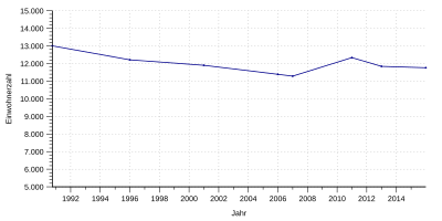
Population development
| year | Residents |
|---|---|
| 3rd October 1990 | 13.008 |
| December 31, 1995 | 12,214 |
| December 31, 2000 | 11,902 |
| December 31, 2005 | 11,391 |
| December 31, 2006 | 11,287 |
| December 31, 2010 | 12,339 |
| December 31, 2012 | 11,844 |
| December 31, 2015 | 11,763 |
| June 30, 2016 | 11,931 |
politics
Mayor (since 1945)
- Wilhelm Presuhn (NSDAP) until April 1945
- Kurt Eckart (SPD), May to June 1945
- Karl Herfurth (KPD), from July 1945
- Paul Drese (SED), 1946 to 1947
- Fritz Singer, 1948 to 1952
- Kurt Boose, deputy from 1951
- Gerry Meißel (SED), provisional from 1952 / Edmund Jatz
- Martha Wessler (SED), February 20, 1953 to February 19, 1976
- Liselotte Wehowski (SED), February 20, 1976 to August 20, 1986
- Frank Klappach (SED), August 21, 1986 to September 30, 1988
- Karin Zeisler (SED), October 1, 1988 to May 1990
- Thomas Heilmann (CDU), May 28, 1990 to June 30, 2001
- Jürgen Elste (FDP), July 1, 2001 to June 30, 2008
- Árpád Nemes (CDU), July 1, 2008 to June 30, 2015
- Christoph Schulze (CDU), since July 1, 2015
City council
The city council in Bad Dürrenberg has 28 voting members. It is composed of 27 city councilors and the mayor of Bad Dürrenberg.
Since the local elections on May 26, 2019, the mandates have been distributed as follows:
- CDU : 8 members
- FDP : 5 members
- AfD : 4 members
- DIE LINKE : 3 members
- Independent voter community (UWG): 2 members
- Voting community for craftsmen and tradespeople (WG HuG): 2 members
- Pro Bad Dürrenberg Community of Voters (WG PBD): 2 members
- General Free List Tollwitz-Nempitz (AFL): 1 member
- SPD : 1 member
coat of arms
The coat of arms was approved on April 15, 1947 by the Minister of the Interior of the provincial government of Saxony-Anhalt.
Blazon : "In red over blue water, a silver building with a tower-like roof, black windows, door and silver entrance stairs."
The building in the city's coat of arms represents Dürrenberg's landmark, the so-called art or Borlach tower . The waves indicate the geographic location of the city on the Saale.
flag
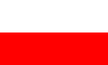
The flag of the city of Bad Dürrenberg is striped white - red (1: 1).
Town twinning
Bad Dürrenberg maintains partnerships with Caudebec-lès-Elbeuf in France , Ciechocinek in Poland , Encs in Hungary and Melle in Lower Saxony .
Culture and sights
- Kurpark (10 ha ) u. a. with cold inhalation hall, flower clock and information point for the funeral of Bad Dürrenberg
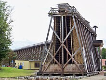
- Largest contiguous graduation tower in Germany (636 m long)
- Borlach Tower with Borlach Museum on the history of salt in the region
- Home parlor
- Bird and palm house
- Late Gothic church in the district of Kirchfahrungorf
- Saale cycle path (7 km in the area)
- Sole, coal and history cycle path from Geiseltalsee to Lützen
- First rail tunnel in Germany (177 meters long by today's standards)
- The Catholic Church of St. Boniface is a sacred rotunda with an unusual glass mosaic representation of the crucified Christ in the chancel.
- Museum apartment in the garden city ("old settlement")
- Replica of the first Saxon steam engine (by Christian Friedrich Brendel) in the Witzleben Tower
Historical monuments
- Atonement Cross Kirchfahrorf from the Peasants' War
- War memorial on Borlachplatz in memory of the 151 fallen soldiers of the First World War, inaugurated on August 23, 1925
- Graves for 14 slave laborers in the municipal cemetery
- Graves of 18 forced laborers in the New Cemetery
- Monument from 1959 in the old cemetery for 41 slave laborers from several nations
- War memorial in front of the Protestant church in memory of the participants and fallen soldiers of the Franco-German War of 1870/71
- War memorial on Kirchfrahtorfer Straße in the district of Fahingorf for those who fell in the First World War
- Memorial on OdF-Platz in memory of the " victims of fascism and the imperialist war"
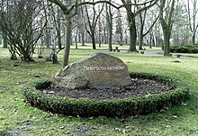
- Hunnenstein with the fabulous imprint of the hand of King Henry I for the Battle of Hungary in 933
- Peasant stone
Regular events
- Fountain Festival: Every last weekend in June; the “little Borlach game” is traditionally performed at the fountain festivals. The development of the brine spring is shown on September 15, 1763 and a public brine measurement is carried out.
- Kurpark Concerts May to September in the Kurpark
- Easter market on Holy Saturday in front of the palm and bird house
- Farmers' market on the first Saturday in September, on Borlachplatz and in front of the palm and bird house
- Advent magic on the second Advent weekend in front of the palm and bird house
- Exhibitions by regional artists in the water tower of the association for water supply and wastewater disposal Bad Dürrenberg
- Day of the open monument, including guided tours to the Borlach shaft, coal railway tunnel, graduation tower
One-time events
The State Horticultural Show Bad Dürrenberg 2022 will take place in 2022 in Bad Dürrenberg under the motto "Salt crystal & blossom magic". It is the fifth state horticultural show in Saxony-Anhalt.
Economy and Infrastructure
Transport links
Bad Dürrenberg has a stop on the Leipzig - Großkorbetha line , which is served hourly by the regional train line RB20. In addition, the city is connected to HAVAG's local transport by the Halle-Ammendorf-Bad Dürrenberg tram line (Halle - Schkopau - Merseburg - Leuna - Bad Dürrenberg) . Line 5, which runs on it, is the longest tram line in the new federal states at around 30 kilometers. There are bus connections to Markranstädt, Merseburg, Günthersdorf and Kleinkorbetha, among others.
| line | Route in the timetable year 2019 |
|---|---|
| RB 20 | Leipzig Hbf - Leipzig-Möckern - Leipzig-Leutzsch - Leipzig-Miltitz - Markranstädt - Bad Dürrenberg - Großkorbetha - Weißenfels - Naumburg (Saale) Hbf - Bad Kösen - Bad Sulza - Apolda - Weimar - Erfurt Hbf - Gotha - Eisenach (operated by Abellio Rail Central Germany ) |
The city is also right on the A 9 , where it has its own junction.
There is a lock in Bad Dürrenberg .
tourism
The former Salzamt was converted into a hostel, and there are three other hotels. There is also the Sole Spa (health, wellness and relaxation) right in the spa park and the health center with a saltwater exercise pool (Event and Service Center Bad Dürrenberg gGmbH).
State Horticultural Show Bad Dürrenberg 2022
On September 14, 2016, the city of Bad Dürrenberg applied to host the 5th Saxony-Anhalt State Horticultural Show in 2022 under the motto “Salt Crystal & Blossom Magic” and was awarded the contract on March 28, 2017.
Personalities
sons and daughters of the town
- Carl Bischof (1812–1884), mining engineer
- Ernst Bernhard Scharf (1828–1888), newspaper publisher of the news for town and country , Oldenburg
- Rudolph Vogel (1847–1923), member of the Reichstag ( German Social Reform Party )
- Helmut Pohle (1925–1994), economist and university professor
- Simone Mangelsdorff (1931–1973), opera singer
- Ibrahim Böhme (1944–1999), politician ( SED / SDP / SPD )
- Willi Opitz (1928–2011), lawyer, major general and rector of the MfS University
- Lars-Broder Keil (* 1963), journalist and book author
- Andreas Ihle (* 1979), world and Olympic champion in canoe racing
People connected to the city

- Johann Gottfried Borlach (1687–1768), Saxon mountain ridge and founder of the salt pans in Artern, Kösen and Dürrenberg
- Novalis (1772–1801), early romantic, philosopher and lawyer
- Johann Bartholomäus Trommsdorff (1770–1837), pharmacist and pharmacist
- Karl von Fritsch (1838–1906), Fideikommissherr on the manor Groß-Goddula, geologist and paleontologist, academy president of the Leopoldina
- Carl Buttenstedt (1845–1910), from 1883 secretary at the Dürrenberg Salt Office
- Georg Engelbert Graf (1881–1952), member of the Reichstag ( SPD ), lecturer and author
- Ernst Fraenkel (1898–1975), political scientist and lawyer
- Christa Maria Ziese (1924–2012), song, concert and opera singer
literature
- Christoph Schulze: 250 years of discovery of the Dürrenberg brine spring 1763-2013 - Festschrift . Publisher: City of Bad Dürrenberg, 2013, A5 format, 31 pages, without ISBN
See also
Individual evidence
- ↑ State Statistical Office Saxony-Anhalt, population of the municipalities - as of December 31, 2019 (PDF) (update) ( help ).
- ↑ History of the districts of Bad Dürrenberg ( Memento from October 4, 2015 in the Internet Archive )
- ^ Karlheinz Blaschke , Uwe Ulrich Jäschke : Kursächsischer Ämteratlas , Leipzig 2009, ISBN 978-3-937386-14-0 , p. 84 f.
- ↑ Complete article on Suite101.de about Bad Dürrenberg an der Saale
- ^ The district of Merseburg in the municipal directory 1900
- ↑ See Frank Falla Archive (in English).
- ^ History of the city of Bad Dürrenberg ( Memento from October 4, 2015 in the Internet Archive )
- ↑ Bad Dürrenberg and its districts on gov.genealogy.net
- ↑ StBA Area: changes from 01.01. until December 31, 2008
- ↑ StBA: Area changes from January 01 to December 31, 2010
- ^ Lexicon cities and coats of arms of the GDR 1979 page 99 ff.
- ↑ Partnerships
- ↑ Cheers in the Saalekreis - Bad Dürrenberg gets the Landesgartenschau 2022 mz-web.de on March 28, 2017. Accessed on March 29, 2017
- ↑ Publication is available, from the Sole Museum


