Caudebec-lès-Elbeuf
| Caudebec-lès-Elbeuf | ||
|---|---|---|

|
|
|
| region | Normandy | |
| Department | Seine-Maritime | |
| Arrondissement | Rouen | |
| Canton | Caudebec-lès-Elbeuf | |
| Community association | Métropole Rouen Normandy | |
| Coordinates | 49 ° 17 ' N , 0 ° 44' E | |
| height | 4-75 m | |
| surface | 3.68 km 2 | |
| Residents | 10,335 (January 1, 2017) | |
| Population density | 2,808 inhabitants / km 2 | |
| Post Code | 76320 | |
| INSEE code | 76165 | |
| Website | http://www.caudebecleselbeuf.fr/ | |
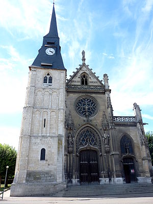
 Notre-Dame church in Caudebec-lès-Elbeuf |
||
Caudebec-lès-Elbeuf is a French municipality with 10,335 inhabitants (as of January 1 2017) in the department of Seine-Maritime in the region Normandy . It belongs to the arrondissement of Rouen and is the main town ( chef-lieu ) of the canton of Caudebec-lès-Elbeuf . The inhabitants of the place are called Caudebecais.
geography
Caudebec-lès-Elbeuf lies on an arch of the Seine . It is surrounded by the neighboring communities of Saint-Aubin-lès-Elbeuf in the north, Saint-Pierre-lès-Elbeuf in the east and Elbeuf in the south and west.
history
Caudebec-lès-Elbeuf is located exactly at the point where the ( Peutinger tablet ( tabula Peutingeriana ) ) from the year 300 lists the Galloceltic settlement Uggade . The settlement is on the former connection from Paris to Rouen . The place name comes from the Norman Caldebec between 962 and 996 (synonymous with cold brook ). This is how the name of Caudebec-en-Caux was formed.
Population development
- 1962: 9,270
- 1968: 9,595
- 1975: 9,469
- 1982: 8.963
- 1990: 9.902
- 1999: 9.904
- 2006: 9,676
- 2011: 9,905
Attractions
- Notre Dame church with the Romanesque tower from the 11th century and the organ from 1891
Parish partnership
- Bad Dürrenberg , Saxony-Anhalt, Germany
