
Mont-Cauvaire
| Mont-Cauvaire | ||
|---|---|---|
.svg)
|
|
|
| region | Normandy | |
| Department | Seine-Maritime | |
| Arrondissement | Rouen | |
| Canton | Bois-Guillaume | |
| Community association | Inter-Caux-Vexin | |
| Coordinates | 49 ° 34 ' N , 1 ° 7' E | |
| height | 65-176 m | |
| surface | 9.02 km 2 | |
| Residents | 741 (January 1, 2017) | |
| Population density | 82 inhabitants / km 2 | |
| Post Code | 76690 | |
| INSEE code | 76443 | |

Mont-Cauvaire is a French municipality with 741 inhabitants (as of January 1 2017) in the department of Seine-Maritime in the region Normandy . It belongs to the arrondissement of Rouen and the canton of Bois-Guillaume (until 2015: canton of Clères ).
geography
Mont-Cauvaire is about 14 kilometers north of Rouen . Mont-Cauvaire is surrounded by the neighboring communities of Clères in the north, Authieux-Ratiéville in the northeast, Fontaine-le-Bourg in the east and southeast, Bosc-Guérard-Saint-Adrien in the south, Montville in the south and southwest and Anceaumeville in the west.
Population development
| 1962 | 1968 | 1975 | 1982 | 1990 | 1999 | 2006 | 2013 | |
|---|---|---|---|---|---|---|---|---|
| 411 | 451 | 471 | 557 | 603 | 566 | 607 | 632 | |
| Source: Cassini and INSEE | ||||||||
Attractions
- Saint-Martin church from the 16th century
- Le Rombosc castle from the 17th century, monument historique since 1932
- Domain Le Fosse from the 16th century with pigeon tower, monument historique since 1977
- Chapel of the former Normandy monastery, monument historique since 1975

Domain Le Fosse
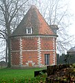
Le Fosse pigeon tower


Personalities
- Max Milner (1923-2008), literary critic
Web links
Commons : Mont-Cauvaire - collection of images, videos and audio files