Darnétal
| Darnétal | ||
|---|---|---|

|
|
|
| region | Normandy | |
| Department | Seine-Maritime | |
| Arrondissement | Rouen | |
| Canton | Darnétal (main town) | |
| Community association | Métropole Rouen Normandy | |
| Coordinates | 49 ° 27 ' N , 1 ° 9' E | |
| height | 13-143 m | |
| surface | 4.93 km 2 | |
| Residents | 9,707 (January 1, 2017) | |
| Population density | 1,969 inhabitants / km 2 | |
| Post Code | 76160 | |
| INSEE code | 76212 | |
| Website | www.ville-darnetal.fr/ | |
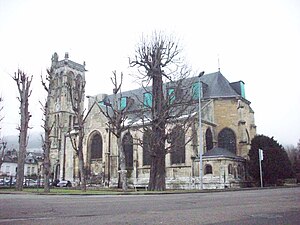
 Saint-Pierre-de-Carville church |
||
Darnétal is a French municipality with 9707 inhabitants (as of January 1 2017) in the department of Seine-Maritime in the region Normandy . It belongs to the arrondissement of Rouen and is the main town ( chef-lieu ) of the canton of Darnétal .
geography
The Robec and Aubette rivers flow through the municipality. Darnétal is surrounded by the neighboring municipalities of Saint-Martin-du-Vivier and Fontaine-sous-Préaux in the north, Roncherolles-sur-le-Vivier in the northeast, Saint-Jacques-sur-Darnétal in the east, Saint-Léger-du-Bourg- Denis in the south and Rouen in the west.
Population development
| Population development in Darnétal | |
|---|---|
| year | Residents |
| 1962 | 9,995 |
| 1968 | 11,062 |
| 1975 | 11,765 |
| 1982 | 10,081 |
| 1990 | 9,779 |
| 1999 | 9.225 |
| 2006 | 9,403 |
| 2011 | 9,492 |
Attractions
- Saint-Pierre-de-Carville and Saint-Ouen de Longpaon churches
- École nationale supérieure d'architecture de Normandie
- Saint Paul Mill
Personalities
- Jacqueline Mazéas (1920–2012), discus thrower
- Jacques Hamel (1930–2016), Catholic priest, born in Darnétal, murdered in the attack in Saint-Étienne-du-Rouvray
Individual evidence
- ↑ INSEE: Population development of Darnétal 1962–2011 ( page no longer available , search in web archives ) Info: The link was automatically marked as defective. Please check the link according to the instructions and then remove this notice.
Web links
Commons : Darnétal - collection of images, videos and audio files
