
Jumièges
| Jumièges | ||
|---|---|---|

|
|
|
| region | Normandy | |
| Department | Seine-Maritime | |
| Arrondissement | Rouen | |
| Canton | Barentine | |
| Community association | Métropole Rouen Normandy | |
| Coordinates | 49 ° 26 ' N , 0 ° 49' E | |
| height | 0-83 m | |
| surface | 18.75 km 2 | |
| Residents | 1,719 (January 1, 2017) | |
| Population density | 92 inhabitants / km 2 | |
| Post Code | 76480 | |
| INSEE code | 76378 | |
| Website | http://www.jumieges.fr/ | |
 Village square and abbey entrance |
||

Jumièges is a French commune with 1,719 inhabitants (at January 1, 2017) in the department of Seine-Maritime in the region Normandy .
geography
Jumièges is located on the right bank of the Seine in a bend in the river between Le Havre and Rouen . Jumièges is part of the Boucles de la Seine Normande Regional Nature Park .
Population development
| year | 1962 | 1968 | 1975 | 1982 | 1990 | 1999 | 2008 | 2017 |
| Residents | 1214 | 1305 | 1474 | 1634 | 1641 | 1714 | 1718 | 1719 |
Attractions
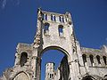
- Jumièges Abbey : founded by St. Philibert ; Jumièges Abbey is one of the greatest and most beautiful ruins in France and is open to the public.

Towers of the Jumièges Abbey

Front view of the abbey

25 m high walls of the abbey
Derelict tower of the abbey

Panorama of the abbey


Web links
Commons : Jumièges - collection of images, videos and audio files
- Ville de Jumièges, website of the municipality (fr)
- Jumièges Abbey (German, photos)
- Jumièges, magnet for tourists (German)