
Sahurs
| Sahurs | ||
|---|---|---|
|
||
| region | Normandy | |
| Department | Seine-Maritime | |
| Arrondissement | Rouen | |
| Canton | Canteleu | |
| Community association | Métropole Rouen Normandy | |
| Coordinates | 49 ° 22 ′ N , 0 ° 57 ′ E | |
| height | 2–101 m | |
| surface | 11.23 km 2 | |
| Residents | 1,226 (January 1, 2017) | |
| Population density | 109 inhabitants / km 2 | |
| Post Code | 76113 | |
| INSEE code | 76550 | |
| Website | http://www.sahurs.fr/ | |

Sahurs is a French commune with a population of 1,226 (as at 1st January 2017) in the department of Seine-Maritime in the region Normandy . Sahurs belongs to the Arrondissement of Rouen and is part of the canton of Canteleu (until 2015: canton of Grand-Couronne ).
location
Sahurs is about 13 kilometers southwest of Rouen on the Seine . Sahurs is surrounded by the neighboring communities of Saint-Pierre-de-Manneville in the north, Val-de-la-Haye in the northeast, Hautot-sur-Seine in the east, Grand-Couronne in the southeast, Moulineaux and La Bouille in the south and Caumont in the west .
Population development
| 1962 | 1968 | 1975 | 1982 | 1990 | 1999 | 2006 | 2013 |
|---|---|---|---|---|---|---|---|
| 631 | 755 | 788 | 870 | 1.008 | 1,120 | 1.310 | 1,290 |
| Source: Cassini and INSEE | |||||||
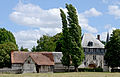
Attractions
- 11th century Saint-Sauveur church, historic monument since 1928
- Remains of the old Saint-Maur church
- Sahurs Castle
- Marbeuf mansion , monument historique since 1945, with Notre-Dame-de-la-Paix chapel, each from the 16th century
- old castle of Soquence from the 16th century, monument historique since 1988/1998
- Trémauville Castle

Saint-Sauveur church
Marbeuf Manor


Personalities
- Pierre de Marbeuf (1596–1645), poet
Web links
Commons : Sahurs - Collection of images, videos and audio files