
Esteville
| Esteville | ||
|---|---|---|

|
|
|
| region | Normandy | |
| Department | Seine-Maritime | |
| Arrondissement | Rouen | |
| Canton | Bois-Guillaume | |
| Community association | Inter-Caux-Vexin | |
| Coordinates | 49 ° 36 ' N , 1 ° 13' E | |
| height | 156-176 m | |
| surface | 5.29 km 2 | |
| Residents | 495 (January 1, 2017) | |
| Population density | 94 inhabitants / km 2 | |
| Post Code | 76690 | |
| INSEE code | 76247 | |

Esteville is a French municipality with 495 inhabitants (as of January 1 2017) in the department of Seine-Maritime in the region Normandy . It belongs to the arrondissement of Rouen and the canton of Bois-Guillaume (until 2015: canton of Clères ). The inhabitants are called Estevillais .
geography
Esteville is about 20 kilometers north-northeast of Rouen . Esteville is surrounded by the neighboring communities of Cottévrard in the north, Critot in the east, Cailly in the south and southeast, Saint-Gemain-sous-Cailly in the south, Claville-Motteville in the southwest and Bosc-le-Hard in the west.
Population development
| 1962 | 1968 | 1975 | 1982 | 1990 | 1999 | 2006 | 2013 | |
|---|---|---|---|---|---|---|---|---|
| 252 | 261 | 320 | 428 | 378 | 376 | 510 | 522 | |
| Source: Cassini and INSEE | ||||||||
Attractions
- Saint-Firmin church from the 17th century
- Saint-Sulpice church in Touffreville from the 13th century
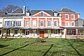
- Esteville Castle from the 17th century
- Hold Emmaüs, the center of the Emmaus movement

Esteville Castle
Hold Emmaüs
.JPG)

Web links
Commons : Esteville - collection of images, videos and audio files