
Saint-Aubin-Epinay
| Saint-Aubin-Epinay | ||
|---|---|---|
|
||
| region | Normandy | |
| Department | Seine-Maritime | |
| Arrondissement | Rouen | |
| Canton | Darnétal | |
| Community association | Métropole Rouen Normandy | |
| Coordinates | 49 ° 25 ' N , 1 ° 11' E | |
| height | 35-159 m | |
| surface | 9.83 km 2 | |
| Residents | 1,033 (January 1, 2017) | |
| Population density | 105 inhabitants / km 2 | |
| Post Code | 76160 | |
| INSEE code | 76560 | |
 Town hall (Mairie) of Saint-Aubin-Épinay |
||

Saint-Aubin-Epinay is a French commune with 1,033 inhabitants (as of January 1 2017) in the department of Seine-Maritime in the region Normandy . It belongs to the arrondissement of Rouen and the canton of Darnétal . The inhabitants are called Saint-Aubinais .
geography
Saint-Aubin-Épinay is located about seven kilometers east-southeast of Rouen and is surrounded by the neighboring communities of Saint-Jacques-sur-Darnétal in the north and northeast, Bois-d'Ennebourg in the northeast, Montmain in the east, Franqueville-Saint-Pierre in the south, Le Mesnil-Esnard to the west and south-west and Saint-Léger-du-Bourg-Denis to the west and north-west.
history
In 1823 the commune was formed from Saint-Aubin-la-Rivière and Épinay-sur-Aubette . During the First World War, there was a camp for German prisoners of war in Saint-Aubin-Épinay on a former factory site.
Population development
| year | 1962 | 1968 | 1975 | 1982 | 1990 | 1999 | 2006 | 2013 |
| Residents | 573 | 573 | 502 | 555 | 917 | 949 | 972 | 1,019 |
| Source: Cassini and INSEE | ||||||||
Attractions
- Saint-Aubin church from the 19th century
- Notre-Dame church in Épinay-sur-Aubette from the 17th century
- Mansion in Meslay
- Watermill

Saint-Aubin church
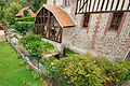
Watermill

