
Morgny-la-Pommeraye
| Morgny-la-Pommeraye | ||
|---|---|---|
.svg)
|
|
|
| region | Normandy | |
| Department | Seine-Maritime | |
| Arrondissement | Rouen | |
| Canton | Le Mesnil-Esnard | |
| Community association | Inter-Caux-Vexin | |
| Coordinates | 49 ° 31 ′ N , 1 ° 15 ′ E | |
| height | 120-168 m | |
| surface | 6.48 km 2 | |
| Residents | 1,023 (January 1, 2017) | |
| Population density | 158 inhabitants / km 2 | |
| Post Code | 76750 | |
| INSEE code | 76453 | |

Morgny-la-Pommeraye is a commune with 1,023 inhabitants (as of January 1 2017) in the Seine-Maritime department in the region of Normandy . It belongs to the arrondissement of Rouen and the canton of Le Mesnil-Esnard (until 2015: canton Buchy ). The inhabitants are called Morinois .
geography
Morgny-la-Pommeraye is about 14 kilometers northeast of Rouen . Morgny-la-Pommeraye is surrounded by the neighboring communities of Pierreval in the north, Bierville in the northeast, Blainville-Crevon in the east, La Vieux-Rue in the south and southwest, Quincampoix in the west and Saint-André-sur-Cailly in the northwest. The former route nationale 319 (today's D919) runs through the municipality .
Population development
| 1962 | 1968 | 1975 | 1982 | 1990 | 1999 | 2006 | 2013 | |
|---|---|---|---|---|---|---|---|---|
| 313 | 309 | 474 | 590 | 793 | 892 | 1.007 | 992 | |
| Source: Cassini and INSEE | ||||||||
Attractions
- Notre-Dame-de-l'Assomption church from the 17th / 18th centuries century
- Sainte-Madeleine church from the 17th century
- Mondétour Castle from the 18th century
- 16th century manor house

Notre-Dame church
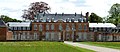
Mondétour Castle


Personalities
Pierre Renaudel (1871–1935), socialist politician