La Vaupalière
| La Vaupalière | ||
|---|---|---|

|
|
|
| region | Normandy | |
| Department | Seine-Maritime | |
| Arrondissement | Rouen | |
| Canton | Notre-Dame-de-Bondeville | |
| Community association | Inter-Caux-Vexin | |
| Coordinates | 49 ° 29 ′ N , 1 ° 0 ′ E | |
| height | 50-138 m | |
| surface | 8 km 2 | |
| Residents | 1,057 (January 1, 2017) | |
| Population density | 132 inhabitants / km 2 | |
| Post Code | 76150 | |
| INSEE code | 76728 | |
| Website | http://www.la-vaupaliere.fr/ | |
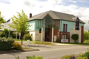
 Town hall (Mairie) of La Vaupalière |
||
La Vaupalière is a French commune with 1,057 inhabitants (as of January 1 2017) in the department of Seine-Maritime in the region Normandy . It belongs to the Arrondissement of Rouen and the canton of Notre-Dame-de-Bondeville .
geography
La Vaupalière is located about nine kilometers northwest of Rouen in the Rouënnais. La Vaupalière is surrounded by the neighboring communities of Roumare in the north and north-west, Saint-Jean-du-Cardonnay in the north and north-east, Maromme in the east, Canteleu in the south-east, Montigny in the south and Hénouville in the west.
The A150 autoroute leads through the municipality.
Population development
| 1962 | 1968 | 1975 | 1982 | 1990 | 1999 | 2006 | 2013 |
|---|---|---|---|---|---|---|---|
| 512 | 555 | 668 | 845 | 902 | 1,026 | 996 | 948 |
| Source: Cassini and INSEE | |||||||
Attractions
- Saint-Léonard church from the 16th century
- Parquet castle from the 17th century
Personalities
- Auguste Le Prévost (1787-1859), archaeologist
- Pierre Bérégovoy (1925–1993), politician (PS), Prime Minister (1992/1993), teacher in La Vaupalière
Web links
Commons : La Vaupalière - Collection of images, videos and audio files

