
Müelte (Geiseltal)
| coat of arms | Germany map | |
|---|---|---|

|
Coordinates: 51 ° 18 ' N , 11 ° 48' E |
|
| Basic data | ||
| State : | Saxony-Anhalt | |
| County : | Saalekreis | |
| Height : | 164 m above sea level NHN | |
| Area : | 98.58 km 2 | |
| Residents: | 8639 (Dec. 31, 2019) | |
| Population density : | 88 inhabitants per km 2 | |
| Postcodes : | 06249, 06255 (Wünsch) , 06268 (Langeneichstädt, Oechlitz) , 06632 (Branderoda, Gröst) |
|
| Primaries : | 034632 (Branderoda, Oechlitz) , 034633 (Gröst) , 034636 (Langeneichstädt, Wünsch) | |
| License plate : | SK, MER, MQ, QFT | |
| Community key : | 15 0 88 235 | |
| City structure: | 12 districts | |
City administration address : |
Markt 1 06249 Müelte (Geiseltal) |
|
| Website : | ||
| Mayor : | Andreas Marggraf ( independent ) | |
| Location of the city of Müuellen in the Saalekreis | ||
  |
||

Müelte (Geiseltal) is a town southwest of the Geiseltalsee in the Saalekreis in Saxony-Anhalt , Germany .
geography


Müelte is located southwest of Halle (Saale) halfway between Querfurt and Merseburg an der Geisel . To the east of the village lies the Geiseltalsee , which arose after the end of lignite mining in the Geiseltal .
City structure
The following are identified as localities in the city:
| Locality | Area in km² | Residents | Districts |
  (clickable map) |
|---|---|---|---|---|
| Branderoda | 5.94 | 208 | Branderoda | |
| Greets | 12.45 | 655 | Almsdorf and Gröst | |
| Langeneichstädt | 21.88 | 1,523 | Langeneichstädt | |
| Munch | 33.52 | 5,879 | Müelte, Neubiendorf , Sankt Micheln , Sankt Ulrich and Stöbnitz | |
| Oechlitz | 11.96 | 533 | Oechlitz and Schmirma | |
| Wish | 12.85 | 689 | Oberwünsch and Niederwünsch |
Neighboring communities
Neighboring communities are Bad Lauchstädt in the north, Braunsbedra in the east, Gleina , Freyburg , Goseck and Weißenfels (all four in the Burgenland district ) in the south and Steigra and Nemsdorf-Göhrendorf in the west.
Incorporations
On October 1, 1929 Möckerling , Zorbau , Zöbigker , Gehüfte , and Eptingen became districts of Müelte. With the advancement of lignite mining in the Geiseltal , these places east of Müelte were relocated in the 1960s and dredged ( devastated ) a few years later . Since October 1, 1939, Stöbnitz, Sankt Micheln and Sankt Ulrich have been districts of Müelte.
In the course of the municipal reorganization of Saxony-Anhalt on January 1, 2006, the municipalities of Branderoda, Gröst, Langeneichstädt and Wünsch were incorporated into Müchi. On January 1, 2010 the incorporation of Oechlitz followed, the administrative community of Upper Geiseltal was dissolved.
history
On the Kohlberg near Müuellen, the Friedrich Schiller University of Jena investigated trenches and around ten settlement pits that were archaeologically recognized in the aerial photograph and in geophysics. The ceramics recovered in the process (double-conical storage vessels and bulbous handle cups) point to a dating in the Bernburg culture of the late Neolithic . Other finds date from the Late Bronze Age and suggest a second settlement during this period.
In a register of the tithe of the Hersfeld monastery , which was created between 881 and 899, Muchilacha is mentioned for the first time in a document as a place with a compulsory tithing requirement, Muchilacha in Friesenfeld and the Muchileburg castle . From the 11th to the 15th century there was a noble family named after the place " von Müelte ".
Müchi received town charter in 1350. Until 1815, the place belonged to the Wettin , later Electoral Saxon office of Freyburg . The decisions of the Congress of Vienna he came to Prussia and in 1816 the county Querfurt in the administrative district of Merseburg of the Province of Saxony assigned to which he belonged until 1944th
In 1936, Müelte (Geiseltal) was officially set as the city name.
Culture and sights
- Since 2005, the Way of St. James has led through Müächen to the grave of the Apostle James in Santiago de Compostela / Northern Spain.
- The Bündorf desert is located near the city .
center


- Listed market square with town hall
- The town hall, built in 1571 in the Renaissance style , stands on the stepped market square . The three-storey building from the late Renaissance has four portals on the outer front with grooved seating niches , baluster columns and frames on the beams and gable. A wooden spiral staircase , which is very rare of its kind in Germany, adorns the interior of the town hall. The cellar vaults are laid out on three floors with barrel vaults . Until around 1735 the middle cellar was used as a torture cellar and to store the Müchelner beer. In this context, there are reports of three underground corridors that ran from here in different directions. The town hall also houses the local history museum, which documents the 300-year history of lignite mining in the Geiseltal. It also provides insights into the work and private life of the miners. Particular attractions are small fossils from mining and the first documentary evidence of coal mining.
- Mining Cabinet (Market 19)
- City Church of St. Jakobi
- The former E-Werk was redesigned into a citizens' hall.
- In the area of the former open-cast lignite mine, which was closed in 1993, the remaining open-pit mine has been flooded since 2003, creating the largest artificial lake in Germany. The flooding of the Geiseltalsee was completed in April 2011. A leisure and tourism area is also being created. The marina was built on the shores of the lake in Munich since 2008. There are a number of lookout points with information boards, lookout towers and shelters.
District Sankt Micheln


- 12 apostle sources
- The Apostle springs are stratified springs created by erosion . Four of them are connected to the Mücheln drinking water network. One of these sources (in Apostelstrasse) is enclosed and can be visited.
- The Geiselquelle rises at the foot of the Veitsberg and is a typical spring spring . The emerging water is the overflow of an underground groundwater basin . The above-ground precipitation area behind the source is about 34 km². Before lignite mining began, the spring was one of the largest springs in Central Germany. The name Geisel is derived from the Old Norse word geis (an) , from which Geysir also comes. It means "to break forth with power". The Apostle springs in the immediate vicinity are also classified as spring springs. The productivity of the Geiselquelle was originally estimated at around 400 to 600 liters per second when the opencast mine had no influence on the groundwater level. The hostage was very rich in fish and seventeen mills were operated with its water. Today the mill trail leads past five of these mills. The stream was laid as early as 1540. Further laying took place through the mine outcrops between 1938 and 1965. For several years the spring has been pouring up to 35 liters per second. Today - after a last relocation in 2009 as part of the renovation work on the opencast mine - it flows into the Geiseltalsee, leaves the lake at Frankleben and flows in its old bed to Merseburg, where it flows into the Saale .

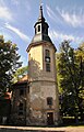
District Sankt Ulrich
- Moated castle
- Castle Church : Luther Church. It was built in the Baroque style from 1790 to 1795 by the Merseburg master builder JW Crysellius. The stylish interior has been preserved. There are valuable grave slabs in the church. The interior was renovated from 1987 to 1989, and the exterior from 1992 to 1993.
- The landscape park was created around 1720 as a palace park parallel to the baroque garden under the von Breitenbauch . After 1945 there were losses, but the facility was declared a "Protected Park" in 1977. It has 250 year old trees and makes a well-groomed impression again.
- Baroque garden
Neubiendorf district

- Geiseltalsee Church . Built in 1928 as the Catholic Herz-Jesu-Kirche, profaned in 2006 , today by the Geiseltalsee-Kirche e. V. Munch used.
District of Stöbnitz

- church
- Campsite and beach (textile and nudist) at the Geiseltalsee
- Pauline observation tower on the Geiseltalsee
Gröst district
- St. Kilian's Church
Schmirma district

- Church with the pictures of Karl Völker
Branderoda district
- church
District Oechlitz
- St. Gotthard Church
- Stone cross
District of Langeneichstädt

- St. Nicholas Church
- St. Bruno Church
- St. Wenceslas Church
- Tomb of the dolmen goddess and Eichstädter Warte
- Post mill
District Wünsch

- St. John's Church
- St. Nicholas Church
leisure offers
- Mueller dance group
- VfH cycling club
- Bowling club
- Football club
- Youth meeting on Bummi
- Handball club
- Volleyball club
- Chess club
- Musikverein "Geiseltaler Musikanten" e. V.
- DLRG local group Geiseltalsee e. V.
gallery
- Pictures from Müelte

Renaissance bay window of the moated castle

View from the baroque garden to Müelte

Manor mill

Hohmannmühle
Luther Church

Rectory in Müelte


politics
Municipal council
The elections in May 2019 resulted in this distribution of seats:
- CDU / SPD parliamentary group: 6 seats
- FWG-PM-FDP parliamentary group: 7 seats
- Non-attached: 2 seats
- Mobile Geiseltal parliamentary group: 3 seats
- AfD parliamentary group: 2 seats
- Total: 20 seats
mayor
In the election for mayor in September 2018, Andreas Marggraf (independent) was able to prevail with 57.6% of the votes against the opposing candidates Annett Beutler (36.8%) and Maik Patzer (5.5%). He took office on January 1, 2019 and is therefore in his second term.
coat of arms
Blazon : "In green a golden, nimbly, silver, bearded man with wide-sleeved, golden undergarment and a poncho-like cape, a black pilgrim hat covered with a silver pilgrim shell and black shoes, in the outstretched hands on the right a silver pilgrim's staff , on the left a fallen silver pilgrim shell."
The man in the coat of arms is St. James , whom the city of Müelte first listed in a council seal in 1463.
Town twinning
Müelte maintains city partnerships with:
- Hemsbach in Baden-Württemberg (since October 3, 1990)
- Bois d'Arcy in France (since March 22, 1997)
- Rudno nad Hronom in Slovakia
Economy and Transport


traffic
The Merseburg – Querfurt railway runs through the area of the city of Müuellen . In addition to the old train station in Müächen (Geiseltal), where the DB Regio Südost passenger trains regularly meet, there is a stop in the Langeneichstädt district. In addition, a new stop in the city of Muenchen (Geiseltal) was created, which is located closer to the center. The viaduct in Müelte was only created in the course of the route relocation as a result of the progressing open-cast lignite mining.
In the past there was also a connection to the regional tram network between Halle (Saale), Merseburg, Müelte and Bad Dürrenberg, but this had to give way to the open-cast lignite mine in 1968 (see also tram route Merseburg – Müchi ).
Müelte is about 15 kilometers from the A 38 .
The new Erfurt – Leipzig / Halle line runs between Oechlitz and Langeneichstädt through the territory of the city, at Oechlitz the 297 m long Stöbnitztalbrücke serves to cross the valley of the same name.
economy
Müelte and its districts have a long tradition in plant production, e.g. B. also from sugar beet .
In recent times, Müelte has been focusing on tourism on the Geiseltalsee.
Personalities
- Ahasverus Fritsch (1629–1701), lawyer and hymn poet, Schwarzburg-Rudolstadt Chancellor and Consistorial President
- Christian Friedrich Matthäi (1744–1811), classical philologist, born in Gröst
- Adolf Holst (1867–1945), writer, born in Branderoda
- Paul Rinckleben (1841–1906), sculptor and copper driver
- Martin Lerche (1892–1980), food hygienist and veterinarian
- Heinz Itzerott (1912–1983), natural scientist and plant protector, born in Müuellen
- Franziska (* 1993), singer, born in Almsdorf
literature
- Otto Küstermann : On the history of Müuellen at the Geisel and the surrounding area , pastor in Geusa, 1898
- Karl Gustav Friedrich Otto Wunder called Völker: A contribution to the history of the city of Müuellen, based on the sources of the city archive, lecture given in the Association for Voluntary Nursing and Poor Care of the City of Müchi , Verlag I. Fricke Halle 1877 ( digital copy )
Web links
swell
- ↑ State Statistical Office Saxony-Anhalt, population of the municipalities - as of December 31, 2019 (PDF) (update) ( help ).
- ^ Möckerling on www.genealogy.net
- ^ Zorbau on www.genealogy.net
- ^ Zöbigker on www.genealogy.net
- ↑ Hip on www.genealogy.net
- ↑ Eptingen on www.genealogy.net
- ↑ The place on www.devastiert.de ( Memento from September 23, 2015 in the Internet Archive )
- ↑ Stöbnitz on www.genealogy.net
- ↑ Sankt Micheln on www.genealogy.net
- ^ Ortisei on www.genealogy.net
- ↑ StBA: Changes in the municipalities in Germany, see 2006
- ↑ StBA: Area changes from January 01 to December 31, 2010
- ^ Reg. Thur. No. 287
- ^ Karlheinz Blaschke , Uwe Ulrich Jäschke : Kursächsischer Ämteratlas. Leipzig 2009, ISBN 978-3-937386-14-0 ; P. 34 f.
- ↑ The district of Querfurt in the municipal directory 1900
- ↑ Short tourist guide to the cities of Braunsbedra, Müelte and Bad Lauchstädt
- ↑ A trio celebrates the end of the flooding , Mitteldeutsche Zeitung of April 30, 2011, accessed on September 1, 2011 ( digitized version )
- ↑ http://www.geiseltalseekirche.de/
- ↑ Homepage of the Geiseltalsee
- Jump up ↑ Müelte Dance Group
- ↑ geiseltalsee.dlrg.de
- ↑ City of Müuellen (Geiseltal) - city council. Retrieved October 17, 2019 .
- ↑ Locations of sugar production
Branderoda | Greets | Langeneichstädt | Mussels | Oechlitz | Wish
Bad Dürrenberg | Bad Lauchstädt | Barnstädt | Braunsbedra | Farnstädt | Cable ketal | Landsberg | Leuna | Merseburg | Müelte (Geiseltal) | Nemsdorf-Göhrendorf | Obhausen | Petersberg | Querfurt | Salzatal | Schkopau | Shrapnel | Steigra | Teutschenthal | Wettin-Löbejün