
Hips
Gehüfte is a modern desert in the Saalekreis in Saxony-Anhalt . It fell victim to lignite mining in the Geiseltal .
Geographical location
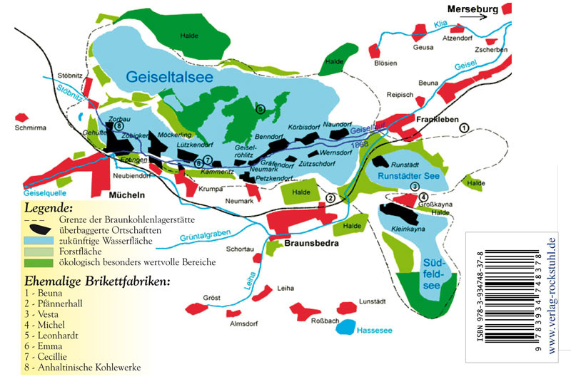
Hip was in the Geiseltal north-east of Müelte . Neighboring towns were Zorbau in the north, Zöbigker in the west and Müelte in the southwest. The former town hall is now on the southwestern edge of the Geiseltalsee in the area of the Marina Müuellen. There is a street called Gehüfte in the city of Müuellen . Through the hips flowed a tributary of the hostage , which was called the blade .
history
Gehüfte was created after 1327 when the Kaltenborn monastery property was divided in Eptingen . At that time it consisted of a single farm or hamlet, from which the place name is derived. Until 1815 the place belonged to the Wettin , later Electoral Saxon office of Freyburg . The decisions of the Congress of Vienna he came to Prussia and in 1816 the county Querfurt in the administrative district of Merseburg of the Province of Saxony assigned to which he belonged until 1944th
On October 1, 1929, Gehüfte was incorporated into the town of Müuellen . In the course of the lignite mining in the Geiseltal , Gehüfte was relocated in 1968 and mostly dredged ( devastated ) in 1975 . Today only a remnant of the place exists in the area of the Merseburg – Querfurt railway line .
Web links
Individual evidence
- ↑ Map with the missing places in the Geiseltal
- ↑ Marina Müelte on the Geiseltalsee homepage
- ^ Karlheinz Blaschke , Uwe Ulrich Jäschke : Kursächsischer Ämteratlas. Leipzig 2009, ISBN 978-3-937386-14-0 ; P. 34 f.
- ↑ The district of Querfurt in the municipal directory 1900
- ↑ Hip on www.genealogy.net
- ↑ The place on www.devastiert.de ( Memento from September 23, 2015 in the Internet Archive )
Coordinates: 51 ° 18 ′ 39.2 " N , 11 ° 48 ′ 53.6" E