
Möckerling
Möckerling is a modern desert in the former Merseburg-Querfurt district in Saxony-Anhalt . It was destroyed by lignite mining in the Geiseltal .
Geographical location
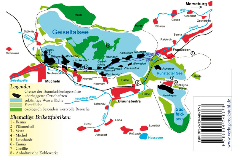
Möckerling was located in the upper Geiseltal east of Müelte . Neighboring towns were Zöbigker in the west, Lützkendorf in the east, Neubiendorf (from 1919) and Eptingen in the south. The western desert of Bündorf belonged to the place . The former corridor of Möckerling is today in the southwest of the Geiseltalsee .
history
Möckerling is probably identical to the place named "Michesdorpf" in the Hersfeld tithe directory . Thus, the founding date can be seen before the year 890, probably even 777. Against this assumption, the fact that Möckerling was first mentioned in a document in the 15th century speaks against it. The name 'Michesdorf', however, suggests a place in direct dependence on the castle of Müelte.
In the 12th century Möckerling was probably incorporated into the Reinsdorf monastery on the Unstrut. This assumption is supported by the fact that the monastery in the village later had some interest and was feudal lord of the parish. In 1485 the brothers Bernhardt, Hansen, Balthasar and Melchior von Breitenbauch were enfeoffed with a few Hufen Landes. In 1525 it is reported that a Sebastian Wurm bought a tithe on the Bindorfer Mark from Georg von Benndorf. There was a manor and a mill in the village . In 1589, the von Behr family owned an oil mill in Möckerling, who, according to the Freyburg registry of inheritance, also own the Siedelhof zu Zöbigker. As early as 1466, the Bitter brothers were entrusted with a meadow 'in front of this oil mill'.
The Möckerling village church, which has existed at least since the late Gothic period , was renewed in the 18th century. Möckerling belonged to the Wettin , later Electoral Saxon office of Freyburg until 1815 . The decisions of the Congress of Vienna the place to Prussia came only in 1816 the county Querfurt in the administrative district of Merseburg of the Province of Saxony assigned to which he belonged until 1944th In 1819 190 inhabitants lived in 43 houses in the village. Due to mining, the population rose to 1150 by 1919.
On October 1, 1929 Möckerling was incorporated into the city of Müuellen . The village church was badly damaged in 1944 during an air raid in World War II . In the course of lignite mining in the Geiseltal , the place was relocated in 1961/62 and excavated ( devastated ) in 1964 . The baptismal font of the Möckerlinger church was placed in the church of St. Micheln .
Web links
literature
- Steffan Bruns: Ortschronik Möckerling, Zöbigker (Saxony-Anhalt, Saalekreis, Geiseltal), with the local family book of the communities. Complete analysis of the church records for the years 1647 - 1703. Plaidt: Cardamina 2014, ISBN 978-3-86424-192-5
Individual evidence
- ↑ Map with the missing places in the Geiseltal
- ↑ Götz Eckardt (editor), Fates of German Monuments in World War II , Volume 2, Henschel Verlag Berlin, ISBN 3-926642-24-6 , page 335
- ^ Karlheinz Blaschke , Uwe Ulrich Jäschke : Kursächsischer Ämteratlas. Leipzig 2009, ISBN 978-3-937386-14-0 ; P. 34 f.
- ↑ The district of Querfurt in the municipal directory 1900
- ^ Möckerling on www.genealogy.net
- ↑ Götz Eckardt (editor), Fates of German Monuments in World War II , Volume 2, Henschel Verlag Berlin, ISBN 3-926642-24-6 , page 335
- ↑ The location on www.devastiert.de ( Memento of the original from September 23, 2015 in the Internet Archive ) Info: The archive link was inserted automatically and has not yet been checked. Please check the original and archive link according to the instructions and then remove this notice.
Coordinates: 51 ° 18 ′ 26.7 ″ N , 11 ° 49 ′ 57.3 ″ E