
Krumpa
|
Krumpa
City of Braunsbedra
Coordinates: 51 ° 17 ′ 46 ″ N , 11 ° 50 ′ 45 ″ E
|
|
|---|---|
| Height : | 119 m |
| Area : | 10.13 km² |
| Residents : | 1164 (Dec. 31, 2004) |
| Population density : | 115 inhabitants / km² |
| Incorporation : | January 1, 2007 |
| Postal code : | 06242 |
| Primaries : | 034632, 034633 |
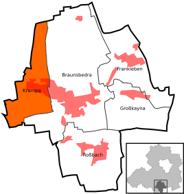  Location of Krumpa in Braunsbedra
|
|
Krumpa is a district of the town of Braunsbedra in the Saalekreis in Saxony-Anhalt .
geography
Krumpa is located between Naumburg (Saale) and Halle (Saale) south of the Geiseltalsee .
history


In a register of the tithe of the Hersfeld monastery , which was created between 881 and 899, Krumpa is mentioned for the first time in a document as the place of tithing Crupa im Friesenfeld .
Until 1815 Krumpa was an official village in the Saxon office of Freyburg and then came to Prussia. In 1589 the spelling was Crumpa . At that time there were 51 possessed men, including 11 Anspänner and 40 Hintersättler in the village, whose corridor comprised 52 Hufen. The hereditary courts in the upper village were owned by the owner of the manor there, but the Freyburg office in the rest of the village and in the village hall. The corridor used to border on Kämmeritz , Petzkendorf , Bedra , Schortau , Gröst , Branderoda , Müchi (Geiseltal) , Eptingen , Zöbigker and Möckerling , some of which had to give way due to the lignite mining in the Geiseltal .
Representatives of the von Rölitz family can be proven to have owned the manor from at least 1486 to 1568. From 1589 to 1728, von Hacke, who had been raised to the baron status, and then von Burkersroda, sat here . After several changes of ownership, the manor came to the Herrfurth family in 1822, who also owned the two manors in Oberthau near Ermlitz . In 1880, the Körbisdorf AG sugar factory acquired the Krumpa manor, which was then dissolved.

On April 1, 1938, Kämmeritz and Lützkendorf became districts of Krumpa. Krumpa, like other neighboring towns, was badly affected by the heavy Allied air raids on the Lützkendorf mineral oil works in 1944 and 1945.
In the course of lignite mining in the Geiseltal , Lützkendorf and part of Krumpa were relocated in 1961 and excavated ( devastated ) in 1963 , Kämmeritz followed from 1966. The church also had branches in Lützkendorf and Petzkendorf, which were also excavated.
On August 27, 2006, 911 voters voted on a possible incorporation of the municipality of Krumpa into the city of Braunsbedra. The question: “Do you agree to the incorporation of the municipality of Krumpa into the city of Braunsbedra on January 1, 2007?” Answered 399 with yes , 151 with no and one vote was invalid.
The municipality of Krumpa lost its political independence on January 1, 2007 when it was incorporated into the town of Braunsbedra .
traffic
The Merseburg – Querfurt railway runs along the southern outskirts. DB Regio Südost serves a stop at the south-eastern exit of the town every hour.
South of the community, the federal highway 176 runs from Sömmerda to Weißenfels . The place itself is on Landstrasse 178.
Personalities
- Moritz Kloss (1818–1881), teacher and sponsor of gymnastics
- Olaf Keller (1945–2019), soccer goalkeeper and coach
Individual evidence
- ^ Krumpa Evangelical Church
- ^ Reg. Thur. No. 287
- ^ Lützkendorf on www.genealogy.net
- ↑ The locations on www.devastiert.de ( Memento from September 23, 2015 in the Internet Archive )
- ↑ StBA Area: changes from 01.01. until December 31, 2007
Web links
Bedra | Braunsbedra | Braunsdorf | Frankleben | Great Kayna | Krumpa | Loan | Lunstädt | Neumark | Reipisch | Rossbach | Schortau