
Braunsbedra
| coat of arms | Germany map | |
|---|---|---|

|
Coordinates: 51 ° 17 ' N , 11 ° 54' E |
|
| Basic data | ||
| State : | Saxony-Anhalt | |
| County : | Saalekreis | |
| Height : | 104 m above sea level NHN | |
| Area : | 74.3 km 2 | |
| Residents: | 10,533 (Dec 31, 2019) | |
| Population density : | 142 inhabitants per km 2 | |
| Postcodes : | 06242, 06259 | |
| Primaries : | 034633, 034637 | |
| License plate : | SK, MER, MQ, QFT | |
| Community key : | 15 0 88 065 | |
| LOCODE : | DE BBD | |
| City structure: | 5 districts | |
City administration address : |
Markt 1 06242 Braunsbedra |
|
| Website : | ||
| Mayor : | Steffen Schmitz ( CDU ) | |
| Location of the city of Braunsbedra in the Saalekreis | ||
  |
||

Braunsbedra is a town in the Saalekreis in Saxony-Anhalt , which emerged in 1943 from the merger of Bedra and Braunsdorf.

geography
Braunsbedra is located approx. 25 km south of Halle (Saale) and approx. 35 km west of Leipzig .
The Geiseltalsee, the largest lake in Saxony-Anhalt, which is also the largest artificial lake in Germany, was built near Braunsbedra . The flooding began on June 30, 2003 and ended on April 29, 2011.
City structure
The following are identified as localities and districts of the city:
| Localities and districts | Area in km² | Residents | Locations |
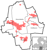  (clickable map) |
|---|---|---|---|---|
| Braunsbedra | 29.4 | 6,381 | Bedra, Blösien-West, Neumark , Neumark-Nord and Schortau | |
| Frankleben | 11.3 | 1,691 | Reipisch and Frankleben | |
| Great Kayna | 9.2 | 1,285 | Great Kayna | |
| Krumpa | 14.2 | 1,208 | Krumpa | |
| Rossbach | 10.2 | 1,754 | Leiha , Lunstädt , Roßbach and Roßbach-Süd |
history

In a register of the tithe of the Hersfeld monastery , which was created between 881 and 899, Braunsdorf, Bedra and Schortau are mentioned for the first time as places in Friesenfeld that are subject to a tithing obligation .
The owners of Bedra were the knights Knuth (1260–1321), the inns of Bedra (1321–1413) and those of Bünau (1413–1460). Between 1420 and 1440, the von Bose owners of Braunsdorf and Bedra. The following are the von Taubenheim (1460–1755), the von Brühl (1755–1794) and the last von Helldorff (1794–1945) owners of the place.
Braunsdorf and Bedra belonged to the Wettin , later Electoral Saxon office of Freyburg until 1815 . The decisions of the Congress of Vienna they came to Prussia and were 1,816 county Querfurt in the administrative district of Merseburg of Saxony Province allocated to which they belonged to the 1944th
Braunsbedra received its town charter on July 5, 1993.
Church history


The church in the Neumark district was destroyed in an air raid in 1944, and the ruins were removed in the 1950s.
Benndorf had a Romanesque hall church that was destroyed by an air raid in 1944. The ruin was initially prepared as a summer church until it was demolished in 1955 with the entire district because of the open-cast brown coal mine.
Geiselröhlitz had a Romanesque church made of stone masonry. This was destroyed by an air raid in 1944, and the baroque pulpit altar and the organ of a Silbermann student were also destroyed. In 1950 the church was rebuilt using parts of the destroyed Neumarker Church, then demolished in 1964 for open-cast brown coal mining. The town's manor was also destroyed in the bombing raids in 1944 and the ruins were torn down in 1964.
Incorporations
On July 1, 1950, the community of Schortau was incorporated.
On January 1, 1962, the communities of Neumark with the districts of Benndorf (Geiseltal) (on January 1, 1960 to Neumark) and Wernsdorf (on July 1, 1950 to Benndorf) were incorporated.
On January 1, 2004, the communities Frankleben with the district Reipisch (on July 1, 1950 to Frankleben), Großkayna and Roßbach with the districts Leiha and Lunstädt (both on July 1, 1950 to Roßbach) were incorporated.
On January 1, 2007, the municipality of Krumpa (Geiseltal) was incorporated.
Memorials


- Memorial stone for Michael Caßler , inventor of the balance bike
- Tallboy memorial in Krumpa: Original head piece of an English bunker-breaking six-ton tallboy bomb that works on the earthquake principle
- Memorial by the sculptor Gerhard Geyer from 1950 in memory of perished concentration camp prisoners , moved from the Neumark district to the park settlement in 1969 because of the lignite mining
- Graves in the cemetery of the Neumark district for 43 victims of forced labor from Poland and Italy
politics
City council
The council consists of 28 council members and the mayor.
(Status: local elections on June 13, 2004)
Local election 2014:
- CDU: seats 13
- DIE LINKE - Seats 4
- SPD: seats 3
- Braunsbedra volunteer fire brigade: Seats 3
- BWG Braunsbedraer constituency: seats 1
- BHV Braunsdorfer Heimatverein: Seats 1
- FDP: seats 1
- SVF, RHV Sportverein Friesen, Reipischer Heimatverein: Seats 1
- SVG Sportverein Großkayna: Seats 1
- Total: 28 seats
coat of arms
Blazon : In the coat of arms, divided by green and gold, there is a silver plow at the top and a black eight-spoke wheel at the bottom .
The coat of arms of the city of Braunsbedra shows a tilting plow in the upper part . The first wooden wheel is symbolically reproduced in the lower part of the coat of arms. The color green in the coat of arms stands for the green Geiseltal, in the middle of which lies the city of Braunsbedra. Years of mining of brown coal , the "black gold" in the Geiseltal, led to the gold-colored design of the coat of arms in the lower part.
Economy and Infrastructure
traffic

The Merseburg-Süd junction of Autobahn 38 Göttingen-Leipzig is partly in the Braunsbedra urban area. The state roads L 178 and L 179 run through the city.
The railway stations Braunsbedra and Frankleben as well as the stops Braunsbedra Ost and Krumpa on the Merseburg – Querfurt railway line are in the urban area . These are served hourly by the RB 78 line of the DB Regio Südost during the day. The nearest train station, where long-distance trains stop, is Halle (Saale) Hauptbahnhof .
Braunsbedra belongs to the tariff area of the Central German Transport Association (MDV).
Culture and tourism


- In the central workshop in Pfännerhall, which served as an industrial repair base until 1988, a regional development center and extracurricular learning center for nature, culture and technology was established. The forest elephant exhibition “Pfännerhall Find Spot” has been on view there since 2015 . There is u. a. the reconstruction of a 200,000 year old elephant, the skeleton of which was found in 1986 at Geiseltalsee. In March 2019 the ABORA exhibition "Did Columbus Came 15,000 Years Too Late?" Was integrated into the exhibition program. This exhibition is to be supplemented by an ABORA IV special exhibition in 2020, which will provide information about the origins of seafaring and the early historical cultural exchange.
- The pier, completed in 2014, is the first in Saxony-Anhalt
- Castles in Bedra and Frankleben
- Beach on Geiseltalsee with diving base in Frankleben and on the Hasse with campsite, volleyball field and nudism in Roßbach
Personalities
Sons and daughters of the church
- Michael Caßler (1733–1772), Böttcher, born in Braunsdorf
- Otto von Helldorff (1833–1908), member of the Reichstag
- Ferdinand von Helldorff (1835–1893), Prussian district administrator
- Rudolf Sachsenweger (1916–2007), ophthalmologist, born in Nahlendorf
literature
- City administration Braunsbedra (Hrsg.): Braunsbedra A city in transition. Stadtbild-Verlag, Leipzig 2011, ISBN 978-3-942146-19-7 .
Web links
Individual evidence
- ↑ State Statistical Office Saxony-Anhalt, population of the municipalities - as of December 31, 2019 (PDF) (update) ( help ).
- ↑ General statute of the city of Braunsbedra from December 3, 2014 (PDF)
- ↑ Municipalities presented - today: Braunsbedra , in: Saalekreis-Kurier, No. 3/2007, of December 15, 2007, p. 5. Accessed on April 17, 2020.
- ↑ Steffan Bruns: Geiseltalchroniken: History of the Geiseltal and its surroundings . BoD - Books on Demand, Norderstedt 2020, ISBN 978-3-7407-6351-0 , p. 289 .
- ↑ A trio celebrates the end of the flooding. In: Mitteldeutsche Zeitung. April 30, 2011, accessed on September 1, 2011 ( geiseltalsee-ifv.de digitized version ).
- ^ Karlheinz Blaschke , Uwe Ulrich Jäschke : Kursächsischer Ämteratlas. Leipzig 2009, ISBN 978-3-937386-14-0 , p. 34 f.
- ↑ The district of Querfurt in the municipal directory 1900
- ↑ braunsbedra.de ( Memento from April 13, 2014 in the Internet Archive )
- ↑ Catholic Church of St. Heinrich in Neumark
- ↑ a b Federal Statistical Office (ed.): Municipalities 1994 and their changes since 01.01.1948 in the new federal states. Metzler-Poeschel publishing house, Stuttgart 1995, ISBN 3-8246-0321-7 .
- ↑ StBA Area: changes from 01.01. until December 31, 2004
- ↑ StBA Area: changes from 01.01. until December 31, 2007
- ↑ braunsbedra.de
Bad Dürrenberg | Bad Lauchstädt | Barnstädt | Braunsbedra | Farnstädt | Cable ketal | Landsberg | Leuna | Merseburg | Müelte (Geiseltal) | Nemsdorf-Göhrendorf | Obhausen | Petersberg | Querfurt | Salzatal | Schkopau | Shrapnel | Steigra | Teutschenthal | Wettin-Löbejün