
Neumark (Braunsbedra)
|
Neumark
City of Braunsbedra
Coordinates: 51 ° 17 ′ 37 ″ N , 11 ° 52 ′ 18 ″ E
|
||
|---|---|---|
| Incorporation : | January 1, 1962 | |
| Postal code : | 06242 | |
| Area code : | 034633 | |
Location of Neumark in Saxony-Anhalt |
||


Neumark is a district of the town of Braunsbedra in the Saalekreis in Saxony-Anhalt .
Geographical location
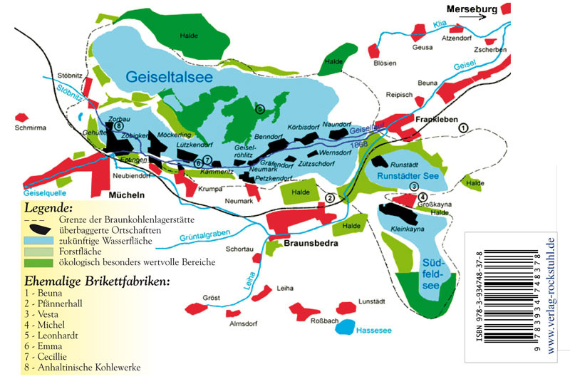
Today's Neumark is located on the south bank of the Geiseltalsee north-west of Braunsbedra, on the road to Müchi (Geiseltal) . Neighboring places are today Krumpa in the west and Braunsbedra in the southeast. To the north of the lake is the 20th century settlement '' Neumark-Nord ''.
The original center of Neumark was in the Geiseltal north of the current location. Like the Neumark and Neumark-Ost colony, it fell victim to lignite mining and is now located in the Geiseltalsee. Neighboring towns to the old town of Neumark were Geiselröhlitz in the west, Gräfendorf in the east and Petzkendorf in the south.
history
Until 1815 Neumark belonged to the Wettin , later Electoral Saxon office of Freyburg . The decisions of the Congress of Vienna the place to Prussia came only in 1816 the county Querfurt in the administrative district of Merseburg of the Province of Saxony assigned to which he belonged until 1944th Since 1918 Neumark had a connection to the Merseburg – Müchi tram route . In 1927, the Petzkendorf estate was assigned to the neighboring village of Neumark. On April 1, 1937, Graefendorf and Geiselröhlitz were incorporated into Neumark.
In 1944 the Romanesque village church of Neumark was destroyed in an air raid . The ruin was demolished in the 1950s. Parts of the church were used for the reconstruction of the village church Geiselröhlitz , which was also destroyed , but which was later also demolished for open-cast brown coal mining.
The administrative reform in the GDR in 1950 brought Neumark and its districts from the Querfurt district to the Merseburg district . On January 1, 1960, the corridors of Benndorf / Geiseltal, which was excavated in the 1950s by the Geiseltal opencast mine, and its former districts were incorporated into Neumark. On January 1, 1962 Neumark was incorporated into Braunsbedra.
The advancing lignite mining in the Geiseltal also affected Neumark and its districts from 1961. They were relocated or dredged ( devastated ) in the following years :
| places | Year of relocation | Year of devastation |
|---|---|---|
| Petzkendorf | 1961 | 1968 |
| Neumark (old town center on the Geisel) | 1963 | 1966 |
| Graefendorf | 1963 | 1966 |
| Geiselröhlitz | 1967 | 1967 |
| Neumark Colony | 1968 | 1975 |
| Neumark-East | 1968 | 1975 |
Today Neumark consists of a district of Neumark south of Petzkendorf between Braunsbedra and Krumpa, and Neumark-Nord north of the former open-cast mine west of Blösien . The latter was not yet available in a table sheet from 1937.
Individual evidence
- ↑ Map with the missing places in the Geiseltal
- ^ Karlheinz Blaschke , Uwe Ulrich Jäschke : Kursächsischer Ämteratlas. Leipzig 2009, ISBN 978-3-937386-14-0 ; P. 34 f.
- ↑ The district of Querfurt in the municipal directory 1900
- ^ Petzkendorf on www.genealogy.net
- ↑ Gräfendorf on www.genealogy.net
- ↑ Geiselröhlitz on www.genealogy.net
- ↑ Götz Eckardt (editor), Fates of German Monuments in World War II , Volume 2, Henschel Verlag Berlin, ISBN 3-926642-24-6 , page 304
- ^ Benndorf on www.genealogy.net
- ^ Neumark on www.genealogy.net
- ↑ The location on www.devastiert.de ( Memento of the original from September 23, 2015 in the Internet Archive ) Info: The archive link was inserted automatically and has not yet been checked. Please check the original and archive link according to the instructions and then remove this notice.
- ↑ Table sheet from 1937