
Zorbau (Müelte)
Zorbau is a modern desert in the former Merseburg-Querfurt district in Saxony-Anhalt . It was destroyed by lignite mining in the Geiseltal .
Geographical location
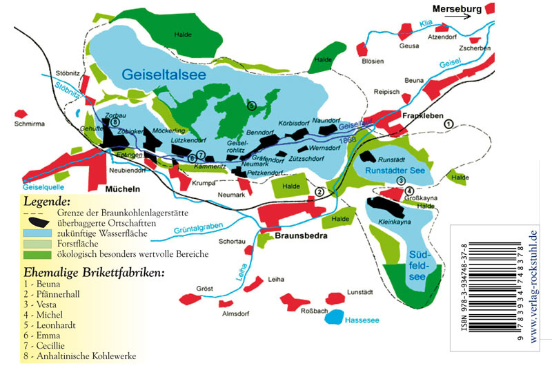
Zorbau was located in the Geiseltal northeast of Müelte above the confluence of the Geisel and Stöbnitz rivers. Neighboring towns were Zöbigker in the southeast, Gehüfte in the south, and Stöbnitz in the northwest. The former town hall is now located in the southwest of the Geiseltalsee north of the Müuellen marina.
history
Zorbau was originally a Slavic settlement in the vicinity of Müelte Castle. In 1275, when "Zurbowe" was mentioned, the first reliable mention of the place took place. The term "Tzorbouwe" was also used. The place name probably refers directly to the tribal name of the Sorbs (lat. Sorabi ). Agnes, Margravine of Brandenburg, and Magnus, Duke of Braunschweig, gave the Kaltenborn Monastery in 1327 "all the rights they have in Zorbau near Müelte", with all interest and usufruct. From the middle of the 13th century, the von Knute knights built a fortification in Zorbau after they had devoted themselves to robber baronism and thus came into conflict with the sovereigns. After their defeat, their fortifications were razed again.
In 1485 the von Breitenbauch family was enfeoffed with four farms in Zorbau. In 1515 the brothers Bernhardt and Wolf von Breitenbauch had the fiefdom of the so-called Lämmermühle and another mill in Zorbau. After 1540 Zöbigker was defeated in the church of Zorbau, with the remark that it had previously been a separate parish. A Simon Bruhn at that time was the pastor of Zorbau, Eptingen, Gehüfte and Stöbnitz. The Zorbau teacher owned half a hoof of tax-free land in the Bündorf desert .
Until 1815 Zorbau belonged to the Wettin , later Electoral Saxon office of Freyburg . The decisions of the Congress of Vienna the place to Prussia came only in 1816 the county Querfurt in the administrative district of Merseburg of the Province of Saxony assigned to which he belonged until 1944th
On October 1, 1929, Zorbau was incorporated into the city of Müuellen . In the course of the lignite mining in the Geiseltal , Zorbau was relocated in 1968 and dredged ( devastated ) in 1975 .
Church of Zorbau
The church of Zorbau was a simple Romanesque building from the 12th century. Over the centuries, the church was expanded and changed several times in the Gothic and Renaissance styles. A special feature was the wide transverse tower that stood between the nave and the choir in the middle of the church. Around 1500 a small sacristy was added, which was provided with a cross vault as well as with remains of a wall and ceiling painting. The walls were adorned with three grave monuments (epitaphs) with the family arms of those von Breitenbauch around 1580. The Gothic portal on the south side of the village church, which served as the entrance door to the choir, was considered particularly beautiful.
In the Zorbauer Kircher Eptingen and Gehüfte were parish, which had no church buildings of their own. The church with Zorbau and the neighboring places were demolished between 1965 and 1975 due to the progressive opencast mining.
Web links
Individual evidence
- ↑ Map with the missing places in the Geiseltal
- ↑ Marina Müelte on the Geiseltalsee homepage
- ↑ Ernst Eichler: The Slavic place names between Saale and Neisse . tape IV . Domowina-Verlag, Bautzen 2009, ISBN 978-3-7420-1716-1 , p. 127 .
- ^ Zorbau in the history of Bündorf and Neubiendorf
- ^ Karlheinz Blaschke , Uwe Ulrich Jäschke : Kursächsischer Ämteratlas. Leipzig 2009, ISBN 978-3-937386-14-0 ; P. 34 f.
- ↑ The district of Querfurt in the municipal directory 1900
- ^ Zorbau on www.genealogy.net
- ↑ The location on www.devastiert.de ( Memento of the original from September 23, 2015 in the Internet Archive ) Info: The archive link was inserted automatically and has not yet been checked. Please check the original and archive link according to the instructions and then remove this notice.
- ↑ History of the Church Zorbauer
Coordinates: 51 ° 18 ′ 44.4 " N , 11 ° 48 ′ 56.5" E