
Wernsdorf (Geiseltal)
Wernsdorf is a modern desert in the Saalekreis in Saxony-Anhalt . It was destroyed by lignite mining in the Geiseltal .
Geographical location
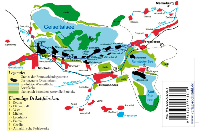
Wernsdorf was in the Geiseltal south of the Geisel , north of Braunsbedra . Neighboring towns were Zützschdorf in the west, Benndorf in the northwest, Körbisdorf in the north and Naundorf in the northeast. The former town hall is now in the southeast of the Geiseltalsee , one kilometer north of the Braunsbedraer shore.
history
Wernsdorf is considered a Franconian foundation and was first mentioned in 1318 in the endowment document of the parish of Benndorf. It should get its name from the first name of the local founder Werino or Wern ((h) er). In Wernsdorf there were two manors that later merged into one. Until 1815 the place belonged to the Wettin , later Electoral Saxon office of Freyburg . By the resolutions of the Vienna Congress Wernsdorf came to Prussia and in 1816 the county Querfurt in the administrative district of Merseburg of the Province of Saxony assigned to which he belonged until 1944th
On October 1, 1936, Zützschdorf became part of Wernsdorf. Due to the administrative reform in 1950, parts of the Querfurt district became part of the Merseburg district . Wernsdorf and its district of Zützschdorf were incorporated into Benndorf on July 1, 1950 as part of this reform.
In the course of lignite mining in the Geiseltal , Wernsdorf was resettled in 1956 and dredged ( devastated ) in 1957 . He thus shared the fate of Zützschdorf and Benndorf. The Romanesque church of Wernsdorf from the 13th century was also demolished. The cemetery was reburied in 1956.
Population development
Wernsdorf has had a small population since it was founded. In 1546 there were ten landlords, in 1562 eleven. There were hardly any changes until the 20th century. In 1910 the place had 115 inhabitants, in 1955 there were 125. During the resettlement in 1956 60 households with 210 inhabitants were named for Wernsdorf.
traffic
With the opening of the Merseburg – Müchi railway line in 1886, Wernsdorf received a train station south of the Geisel in the desolate Zaasdorf district. Although it was closer to Naundorf, the choice of name is probably due to the fact that there were several Naundorf in the wider area. In the early years there were four daily passenger train connections in both directions and even more extensive freight traffic. As early as 1894, the sugar factory in Körbisdorf was given a one kilometer long siding. In 1912 the Pfännerhall briquette factory built south of the Wernsdorf train station also got its own siding. A year earlier, the line from Müuellen to Querfurt had been extended.
Because of the lignite mining, the railway had to be relocated in 1935, it now ran directly between Wernsdorf and Körbisdorf, whereby Wernsdorf also received a new train station. In 1953, the railway line was relocated again, which has since made a wide bend north around Körbisdorf and Benndorf. The next station was now that of Neumark-Bedra. The last relocation took place in 1958, when the railway bypassed a large part of the central (now former) Geiseltal in the south.
Web links
Individual evidence
- ↑ Map with the missing places in the Geiseltal
- ↑ Description of the manor Wernsdorf
- ^ Karlheinz Blaschke , Uwe Ulrich Jäschke : Kursächsischer Ämteratlas. Leipzig 2009, ISBN 978-3-937386-14-0 ; P. 34 f.
- ↑ The district of Querfurt in the municipal directory 1900
- ^ Wernsdorf on www.genealogy.net
- ^ Zützschdorf on www.genealogy.net
- ↑ The location on www.devastiert.de ( Memento of the original from September 23, 2015 in the Internet Archive ) Info: The archive link was inserted automatically and has not yet been checked. Please check the original and archive link according to the instructions and then remove this notice.
- ^ Description of the church in Wernsdorf
- ^ Chronicle of Wernsdorf
Coordinates: 51 ° 18 ′ 11.3 " N , 11 ° 53 ′ 38.1" E