
Gleina
| coat of arms | Germany map | |
|---|---|---|

|
Coordinates: 51 ° 15 ' N , 11 ° 43' E |
|
| Basic data | ||
| State : | Saxony-Anhalt | |
| County : | Burgenland district | |
| Association municipality : | Unstruttal | |
| Height : | 212 m above sea level NHN | |
| Area : | 29.58 km 2 | |
| Residents: | 1199 (Dec. 31, 2019) | |
| Population density : | 41 inhabitants per km 2 | |
| Postal code : | 06632 | |
| Primaries : | 034462, 034632 | |
| License plate : | BLK, HHM, NEB, NMB, WSF, ZZ | |
| Community key : | 15 0 84 150 | |
| LOCODE : | DE GLX | |
| NUTS : | DEE08 | |
| Association administration address: | Markt 1 06632 Freyburg (Unstrut) |
|
| Website : | ||
| Mayor : | Gerd Blankenburg | |
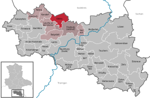
| Location of the municipality of Gleina in the Burgenland district | ||
  |
||


Gleina is a municipality in the Burgenland district in Saxony-Anhalt . It belongs to the Unstruttal community , which has its administrative headquarters in the city of Freyburg .
geography
Gleina is located on the federal highway 180 between Querfurt in the north and Freyburg (Unstrut) in the south. The nature of the soil is rather unusual: the high deposits of peat in the region have been one of the pillars of Gleina's wealth over the past millennium.
The districts Baumersroda , Ebersroda , Gleina and Müncheroda belong to the community .
Climate (table)
| Aadorf, 1981-2010 | ||||||||||||||||||||||||||||||||||||||||||||||||
|---|---|---|---|---|---|---|---|---|---|---|---|---|---|---|---|---|---|---|---|---|---|---|---|---|---|---|---|---|---|---|---|---|---|---|---|---|---|---|---|---|---|---|---|---|---|---|---|---|
| Climate diagram | ||||||||||||||||||||||||||||||||||||||||||||||||
| ||||||||||||||||||||||||||||||||||||||||||||||||
|
Average monthly temperatures and precipitation for Aadorf, 1981–2010
Source:
|
||||||||||||||||||||||||||||||||||||||||||||||||||||||||||||||||||||||||||||||||||||||||||||||||||||||||||||||||||||||||||||||||||||||||||||||||||||||
history


Gleina was first mentioned in 1144. Ancestral seat of the knights "von Gleina" (Glyna, Glina), who were first mentioned in 1245. Until 1815 the place belonged to the Wettin , later Electoral Saxon office of Freyburg . The decisions of the Congress of Vienna he came to Prussia and in 1816 the county Querfurt in the administrative district of Merseburg of the Province of Saxony assigned to which he belonged until 1944th
In 1689 the construction of the Gleina Castle began. In 1830 the Prussian chamberlain Bernhard von Helldorff bought the castle and estate. In 1945 his descendants were expropriated. The castle was used as a nursing home, crèche and rural outpatient clinic until 1996. In 2007, renovation work began.
In 1697 the Trinity Church in Gleina was consecrated. In 1992 the services had to be stopped due to severe structural damage. In 2007 these could be resumed in the renovated church.
In 1907 the water tower was put into operation.
On July 1, 2009, the formerly independent communities Baumersroda and Ebersroda were incorporated.
politics
Municipal council
The municipality council of the municipality of Gleina consists of 12 elected representatives as follows:
(As of: local election June 7, 2009)
mayor
In 1990 Gerd Blankenburg was elected full-time mayor of Gleina from among the members of the municipal council. He was re-elected on May 6, 2001. Also in 2008 and 2015 he was confirmed in office.
traffic
The federal road 180 runs through the municipality of Gleina in a north-south direction , which is superimposed on the state road 209 in the local area. The L 209 runs east from Gleina to Baumersroda and west to Laucha an der Unstrut .
To the south, outside the municipality, runs the federal highway 176 , which leads from Weißenfels to Sömmerda . The Laucha special airfield is located in the immediate vicinity of the municipality .
Business
The agricultural cooperative Gleina e. G. is the largest employer in the area.
Sports
- Gleinaer SV, football, the first men's team plays in the district class 1 Burgenland (season 2014/15)
- Running and Walking Club (LGV) Gleina
Sons and daughters of the church
- Georg Sebastian von Osterhausen (1575–1650), manor owner
- Gottfried Feinler (1650–1721), ev.-luth. Pastor and poet
- Dietrich Schardt († 1636), manor owner and, as the Geschwinde, member of the Fruit Bringing Society founded in 1617
- Ludwig Thienemann (1793–1858), physician and ornithologist
- Heinrich von Helldorff (1833–1876), Prussian district administrator
literature
- Wilhelm Roßberg: History of the village of Gleina in the Querfurt district , RK Jaeckel, Querfurt 1937
Individual evidence
- ↑ State Statistical Office Saxony-Anhalt, population of the municipalities - as of December 31, 2019 (PDF) (update) ( help ).
- ↑ Climate table on wetter24.de
- ^ Karlheinz Blaschke , Uwe Ulrich Jäschke : Kursächsischer Ämteratlas. Leipzig 2009, ISBN 978-3-937386-14-0 ; P. 34 f.
- ↑ The district of Querfurt in the municipal directory 1900
- ↑ http://www.stala.sachsen-anhalt.de/wahlen/bm15/erg/gem/bm.15084150.20150419.ergtab.dr.html
- ↑ Official homepage
Cities: Bad Bibra | Eckartsberga | Freyburg (Unstrut) | Laucha on the Unstrut | Lützen | Naumburg (Saale) | Nebra (Unstrut) | Osterfeld | Weißenfels | Zeitz . Municipalities: An der Poststraße | Balgstädt | Droyziger | Elsteraue | Fin | Finneland | Gleina | Goseck | Gutenborn | Hohenmölsen | Imperial Palace | Karsdorf | Kretzschau | Lanitz-Hassel Valley | My pain | Mertendorf | Molau Country | Schnaudertal | Schönburg | Bumps | Teuchern | Wethau | Weather cap .