
On Poststrasse
| coat of arms | Germany map | |
|---|---|---|

|
Coordinates: 51 ° 10 ′ N , 11 ° 33 ′ E |
|
| Basic data | ||
| State : | Saxony-Anhalt | |
| County : | Burgenland district | |
| Association municipality : | On the fin | |
| Height : | 271 m above sea level NHN | |
| Area : | 44.45 km 2 | |
| Residents: | 1689 (Dec. 31, 2019) | |
| Population density : | 38 inhabitants per km 2 | |
| Postal code : | 06647 | |
| Primaries : | 034463, 034465, 034467 | |
| License plate : | BLK, HHM, NEB, NMB, WSF, ZZ | |
| Community key : | 15 0 84 012 | |
| Community structure: | 9 districts | |
| Address of the municipal administration: |
Dorfstrasse 9, 06647 An der Poststrasse | |
| Mayoress : | Ingrid Hesse | |
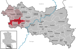
| Location of the community on Poststrasse in the Burgenland district | ||
  |
||

An der Poststraße is a community that arose on July 1, 2009 in the Burgenland district in Saxony-Anhalt . It was formed from the voluntary amalgamation of the communities of Herrengosserstedt , Klosterhäseler and Wischroda . The community belongs to the Verbandsgemeinde An der Finne .
Local division
The following districts belong to the municipality of An der Poststraße:
| District | Residents |
|---|---|
| Braunsroda | 209 |
| Burgheßler | 188 |
| Klosterhäseler | 328 |
| Frankroda | 70 |
| Goessnitz | 156 |
| Herrengosserstedt | 623 |
| Pleismar | 86 |
| Mould | 50 |
| Wischroda | 156 |
Parish name

The name An der Poststraße is derived from the so-called "old Poststraße" between Leipzig and Kassel, which crosses the community . Until the construction of the "Frankfurt-Leipziger-Chaussee" via Eckartsberga , Gernstedt and Kösen in 1806, this was of great importance for traffic.
Attractions
- Orgelbaumuseum Klosterhäseler with the Heerwagen organ building exhibition Klosterhäseler in Schloss Klosterhäseler
literature
- W. Faust: In the valley of the hazel: Historical sketch. Naumburg a. S .: H. Sieling, 1927
Web links
- The municipality on the side of the Verbandsgemeinde
- Website of the organ building museum Klosterhäseler
Individual evidence
- ↑ State Statistical Office Saxony-Anhalt, population of the municipalities - as of December 31, 2019 (PDF) (update) ( help ).
Cities: Bad Bibra | Eckartsberga | Freyburg (Unstrut) | Laucha on the Unstrut | Lützen | Naumburg (Saale) | Nebra (Unstrut) | Osterfeld | Weißenfels | Zeitz . Municipalities: An der Poststraße | Balgstädt | Droyziger | Elsteraue | Fin | Finneland | Gleina | Goseck | Gutenborn | Hohenmölsen | Imperial Palace | Karsdorf | Kretzschau | Lanitz-Hassel Valley | My pain | Mertendorf | Molau Country | Schnaudertal | Schönburg | Bumps | Teuchern | Wethau | Weather cap .