
Verbandsgemeinde An der Finne
| coat of arms | Germany map | |
|---|---|---|

|
Coordinates: 51 ° 12 ' N , 11 ° 34' E |
|
| Basic data | ||
| State : | Saxony-Anhalt | |
| County : | Burgenland district | |
| Area : | 257.22 km 2 | |
| Residents: | 11,521 (Dec. 31, 2019) | |
| Population density : | 45 inhabitants per km 2 | |
| License plate : | BLK, HHM, NEB, NMB, WSF, ZZ | |
| Association key : | 15 0 84 5051 | |
| Association structure: | 7 municipalities | |
| Association administration address : |
Bahnhofstrasse 2 a 06647 Bad Bibra |
|
| Website : | ||
| Mayoress : | Monika Ludwig (independent) | |
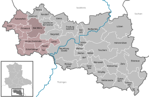
| Location of the Verbandsgemeinde An der Finne in the Burgenland district | ||
  |
||

The Verbandsgemeinde An der Finne is a regional authority in the Burgenland district in the south of the state of Saxony-Anhalt . The Verbandsgemeinde has seven member communities. The seat is in Bad Bibra . The location of most of the member communities on or on the Finns is reflected in their name . It is the first association community that was created in Saxony-Anhalt. Its forerunner was the administrative association An der Finne , which was dissolved on June 30, 2009 . The first mayor was today's district administrator of the Burgenland district, Götz Ulrich ( CDU ).
The municipalities with their districts
- On Poststrasse with Braunsroda, Burgheßler , Frankroda, Gößnitz , Herrengosserstedt , Klosterhäseler , Pleismar, Schimmel and Wischroda
- City of Bad Bibra with Altenroda , Bergwinkel, Birkigt , Golzen , Kalbitz, Krawinkel , Steinbach, Thalwinkel , Wallroda and Wippach
- City of Eckartsberga with Burgholzhausen , radio tower settlement, Lindenberg, Lißdorf, Marienthal, Mallendorf, Millingsdorf, Niederholzhausen, Seena, Thüßdorf and Tromsdorf
- Finn with Billroda , Lossa and Tauhardt
- Finneland with Bernsdorf, Borgau , Kahlwinkel , Marienroda , Saubach and Steinburg
- Kaiserpfalz with Allerstedt , Bucha , Memleben , Wendelstein, Wohlmirstedt and Zeisdorf
- Lanitz-Hassel-Tal with Benndorf, Gernstedt, Hohndorf, Möllern , Niedermöllern, Obermöllern, Pomnitz, Poppel, Rehehausen, Spielberg, Taugwitz and Zäckwar
politics
Association municipal council
The election to the municipal council on May 25, 2014 with a turnout of 55.0% led to the following result:
| Political party | Seats | be right |
|---|---|---|
| CDU | 9 | 43.1% |
| SPD | 2 | 7.8% |
| The left | - | 1.4% |
| NPD | 1 | 2.8% |
| Groups of voters | 9 | 41.9% |
| Individual applicants | 1 | 3.0% |
coat of arms
The coat of arms was approved by the district on July 17, 2009.
Blazon : “Split by green and gold; in front a stalked golden bunch of grapes with eight berries (2: 3: 2: 1); behind a fallen, stalked green linden leaf; in the extended main shield a golden architectural segment with three ogival blue window openings. "
The colors of the association are green and yellow.
The new community took over the coat of arms of the dissolved administrative community An der Finne.
flag
The flag is striped green-yellow (1: 1) and has the coat of arms of the municipality in the center.
Town twinning
The twin town of the municipality has been the small town of Saint-André-de-l'Eure in the French region of Normandy since 2011 .
Individual evidence
- ↑ State Statistical Office Saxony-Anhalt, population of the municipalities - as of December 31, 2019 (PDF) (update) ( help ).
- ↑ State Statistical Office of Saxony-Anhalt: Association municipal council elections in Saxony-Anhalt 2014
- ↑ a b page no longer available , search in web archives: Official Gazette of the State Administrative Office of Saxony-Anhalt No. 10/2009 page 290 (PDF; 225 kB)
- ^ Website of the Verbandsgemeinde
