
Finneland
| coat of arms | Germany map | |
|---|---|---|

|
Coordinates: 51 ° 13 ' N , 11 ° 31' E |
|
| Basic data | ||
| State : | Saxony-Anhalt | |
| County : | Burgenland district | |
| Association municipality : | On the fin | |
| Height : | 258 m above sea level NHN | |
| Area : | 29.42 km 2 | |
| Residents: | 1045 (Dec. 31, 2019) | |
| Population density : | 36 inhabitants per km 2 | |
| Postal code : | 06647 | |
| Area code : | 034465 | |
| License plate : | BLK, HHM, NEB, NMB, WSF, ZZ | |
| Community key : | 15 0 84 133 | |
| Community structure: | 5 districts | |
| Address of the municipal administration: |
Karl-Marx-Strasse 19, 06647 Saubach | |
| Website : | ||
| Mayor : | Rupert Schlosser | |
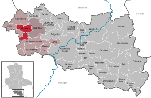
| Location of the municipality of Finneland in the Burgenland district | ||
  |
||

Finneland is a municipality in the Burgenlandkreis in Saxony-Anhalt . It was formed on July 1, 2009 from the voluntary amalgamation of the municipalities of Kahlwinkel , Saubach and Steinburg . The community belongs to the Verbandsgemeinde An der Finne .


geography
Finneland is about 30 kilometers northwest of the district capital Naumburg .
Community structure
The following are identified as part of the municipality:
| Surname | Residents |
|---|---|
| Borgau | 47 |
| Bald angle | 351 |
| Marienroda | 32 |
| Stone castle | 101 |
| Saubach | 683 |
Web links
Individual evidence
- ↑ State Statistical Office Saxony-Anhalt, population of the municipalities - as of December 31, 2019 (PDF) (update) ( help ).
- ↑ StBA: Area changes from January 2nd to December 31st, 2009
Cities: Bad Bibra | Eckartsberga | Freyburg (Unstrut) | Laucha on the Unstrut | Lützen | Naumburg (Saale) | Nebra (Unstrut) | Osterfeld | Weißenfels | Zeitz . Municipalities: An der Poststraße | Balgstädt | Droyziger | Elsteraue | Fin | Finneland | Gleina | Goseck | Gutenborn | Hohenmölsen | Imperial Palace | Karsdorf | Kretzschau | Lanitz-Hassel Valley | My pain | Mertendorf | Molau Country | Schnaudertal | Schönburg | Bumps | Teuchern | Wethau | Weather cap .