
Molau country
| coat of arms | Germany map | |
|---|---|---|

|
Coordinates: 51 ° 4 ′ N , 11 ° 47 ′ E |
|
| Basic data | ||
| State : | Saxony-Anhalt | |
| County : | Burgenland district | |
| Association municipality : | Wethautal | |
| Height : | 220 m above sea level NHN | |
| Area : | 33.94 km 2 | |
| Residents: | 1046 (Dec. 31, 2019) | |
| Population density : | 31 inhabitants per km 2 | |
| Postcodes : | 06618, 06628 | |
| Primaries : | 036694, 036421, 034466 | |
| License plate : | BLK, HHM, NEB, NMB, WSF, ZZ | |
| Community key : | 15 0 84 341 | |
| Community structure: | 11 districts | |
| Association administration address: | Corseburger Weg 11 06721 Osterfeld |
|
| Website : | ||
| Mayor : | Rolf Werner | |
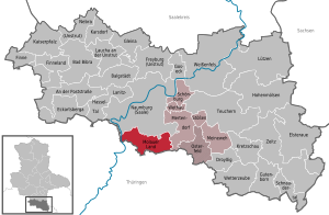
| Location of the municipality of Molauer Land in the Burgenland district | ||
  |
||


Molauer Land is a municipality in the Burgenland district in Saxony-Anhalt .
According to the municipal administration, 1,077 residents lived in the municipality on December 31, 2014.
founding
In the course of the municipal reform in Saxony-Anhalt , it was decided that the municipalities of an association must have at least 1000 inhabitants. Therefore, municipalities with fewer inhabitants had to be merged into new and larger municipalities by 2010. As a result, the communities of Abtlöbnitz (with Mollschütz ), Casekirchen (with Köckenitzsch and Seidewitz ), Leislau (with Crauschwitz and Kleingestewitz ) and Molau (with Aue and Sieglitz ) merged on January 1, 2010 to form the new municipality of Molauer Land. The municipality of Molauer Land is a member municipality of the Wethautal association, which has also been created on this day and has its administrative headquarters in Osterfeld .
structure
As districts are
- Abtlöbnitz ,
- Aue ,
- Casekirchen ,
- Crauschwitz ,
- Small joke ,
- Köckenitzsch ,
- Leislau ,
- Molau ,
- Mollschütz ,
- Seidewitz and
- Sieglitz expelled.
Municipal council
The municipal council consists of 12 council members and the honorary mayor of the municipality. The election for this representative body took place on September 27, 2009, together with the Bundestag election and the elections for the municipal council for the newly established VBG Wethautal. The electoral area was divided into five electoral areas: the previous municipality of Abtlöbnitz, the previous municipality of Casekirchen, the previous municipality of Leislau, Molau with Aue and Sieglitz.
mayor
The honorary mayor Rolf Werner was elected for the first time on September 27, 2009 for a period of seven years.
Web links
Individual evidence
- ↑ State Statistical Office Saxony-Anhalt, population of the municipalities - as of December 31, 2019 (PDF) (update) ( help ).
- ^ [1] Municipal website Molauer Land
- ↑ StBA: Area changes from January 01 to December 31, 2010
- Heimatspiegel Wethautal, official part of June 17, 2009 and July 15, 2009
Cities: Bad Bibra | Eckartsberga | Freyburg (Unstrut) | Laucha on the Unstrut | Lützen | Naumburg (Saale) | Nebra (Unstrut) | Osterfeld | Weißenfels | Zeitz . Municipalities: An der Poststraße | Balgstädt | Droyziger | Elsteraue | Fin | Finneland | Gleina | Goseck | Gutenborn | Hohenmölsen | Imperial Palace | Karsdorf | Kretzschau | Lanitz-Hassel Valley | My pain | Mertendorf | Molau Country | Schnaudertal | Schönburg | Bumps | Teuchern | Wethau | Weather cap .