
Eckartsberga
| coat of arms | Germany map | |
|---|---|---|

|
Coordinates: 51 ° 7 ' N , 11 ° 34' E |
|
| Basic data | ||
| State : | Saxony-Anhalt | |
| County : | Burgenland district | |
| Association municipality : | On the fin | |
| Height : | 243 m above sea level NHN | |
| Area : | 35.96 km 2 | |
| Residents: | 2318 (Dec. 31, 2019) | |
| Population density : | 64 inhabitants per km 2 | |
| Postal code : | 06648 | |
| Area code : | 034467 | |
| License plate : | BLK, HHM, NEB, NMB, WSF, ZZ | |
| Community key : | 15 0 84 125 | |
| LOCODE : | DE EC2 | |
| Website : | ||
| Mayoress : | Marlis Vogel ( CDU ) | |
| Location of the town of Eckartsberga in the Burgenland district | ||
  |
||


.jpg)
Eckartsberga is a small town in the Burgenlandkreis in Saxony-Anhalt (Germany). It belongs to the community of An der Finn .
geography
The town of Eckartsberga is located on the Finne , a mountain ridge on the border between Saxony-Anhalt and Thuringia. It is located in the Saale-Unstrut-Triasland nature park and is around 22 kilometers from Naumburg (Saale) and just under 30 km from Jena and Weimar .
The neighboring communities (clockwise) are: An der Poststraße , Lanitz-Hassel-Tal in Saxony-Anhalt and Bad Sulza in Thuringia.
Districts
In addition to Eckartsberga, the districts belong to Eckartsberga
- Burgholzhausen ,
- Radio tower settlement,
- Lindenberg,
- Lißdorf ,
- Marienthal,
- Mallendorf,
- Millingsdorf,
- Niederholzhausen ,
- Seena,
- Thüsdorf and
- Tromsdorf .
history
The history of Eckartsberga is inextricably linked with the founding and construction of Eckartsburg in 966 by Margrave Ekkehard I of Meißen. The reason was the location on the Sachsenberg on the important Via Regia . The place in front of the castle, laid out as a row village, first appeared in a document in 1073.
In the late Middle Ages , Eckartsberga had market rights , city rights (since 1288), was a minting location and had its own jurisdiction. From 1485 the city was the seat of the Saxon office of the same name. City life was shaped by haulage companies until the middle of the 17th century . In the course of the Saxon fratricidal war , around 60 villages in the Eckartsberga area were on fire on July 15, 1450. A so-called fire column on the outskirts reminds of a witch burning in 1563.
In 1621 the city had a tipper mint, in which interim coins (tipper coins) were struck under the mint masters Christian Gerlach and Bernd Hillard. These were pieces of dump truck and cruiser.
In 1806 Eckartsberga was on the edge of the battlefield of the battle of Jena and Auerstedt . The Eckartsberga office came to Prussia in 1815 (later expanded as the Eckartsberga district ) along with other areas .
At times there were three windmills on the Sachsenberg in the east of the city . The functioning mill from 1831, which is still to the east of the outskirts, a little off the B 87 at a height of 275 m, has a ten-spoke wind turbine with a diameter of 14 meters instead of the usual blades. This type of construction is otherwise common in southern Europe, but is unique in Germany.
On July 1, 2009, the neighboring communities of Tromsdorf and Burgholzhausen were incorporated into the newly formed town of Eckartsberga and the administrative community at An der Finne was dissolved.
mayor
In March 2016, Marlis Vogel was elected for a third term.
coat of arms
Blazon : Divided by red and blue, above a growing golden lion, below a golden lily.
The coat of arms of the city of Eckartsberga is borrowed from the former rule and office of Eckartsberga . On December 1, 2014, the district approved the use of a coat of arms and a flag. The flag of the city of Eckartsberga is red-blue (1: 1) striped (stripes running vertically) and centered with the coat of arms of the city of Eckartsberga.
Town twinning
There is a city partnership with the city of Zwingenberg in the Bergstrasse district in Hesse.
Attractions
- The Eckartsburg with its 36 meter high keep is the town's landmark. Inside the tower there is a tin figure exhibition, which shows the course of the battle near Jena and Auerstedt as a diorama .
- The local museum in the village also presents objects from the Stone Age in its collection.
- The Dutch windmill from 1831 on the Sachsenberg is the last of three examples on the outskirts, which were destroyed by fires in 1839, 1848 and 1851 and were then renewed several times. This last mill has a ten-spoke wind turbine 14 meters in diameter. The tower measures 13 meters from the ground to the top of the roof. The mill was last technically repaired in 2006, and a small exhibition was also created.
- On the site of the former GDR - Pioneer summer camp there is a close to Eckart castle amusement park with maze , mini golf course and summer toboggan run .
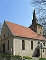
City Church

town hall

Windmill

Memorial to the burning of witches in 1563


traffic

The federal highway 87 ( Leipzig - Ilmenau ) runs through the city . The federal highway 250 via Bad Bibra to Querfurt begins in Eckartsberga. A connecting road leads to the west via Buttstädt to Sömmerda .
Two kilometers south of Eckartsberga is (already in Thuringia) the Eckartsberga (Thür) train station on the Straussfurt - Sömmerda - Buttstädt - Großheringen peppermint railway . Since the cessation of scheduled passenger traffic on the eastern section in December 2017, the station has only been operated sporadically in freight traffic. The closest train station with passenger traffic is Bad Sulza.
The ecumenical pilgrimage from Görlitz to Vacha leads through Eckartsberga.
Personalities
- August Moßdorff (1758–1843), revolutionary and administrative officer
- Adolf Heinrich Gräser (1801–1879), pastor and politician
- Ludwig Abel (1835–1895), violinist and composer
- Marie Weber (1871–1952), landscape painter
- Rolf Friedemann Pauls (1915–2002), Wehrmacht officer and diplomat
- Peter Frenkel (* 1939), athlete
- Karl Hieronymus, the first city architect of Gleiwitz
literature
- Dr. Emsmann, Mayor: History of the Palace and the City of Eckartsberga , printed by Carl August Kümmel in Halle, 1832 digitized
- Heinrich Otte u. Gustav Sommer: Descriptive representation of the older architectural and art monuments of the Eckartsberga district , Halle / Saale 1883
- Louis Naumann : On the history of the ephorie Eckartsberga , published by Eckartshaus-Verlag, 1884
- Louis Naumann: Building blocks of a history of the parish Eckartsberga , published in the Naumburger Tageblatt, local supplement, 1924
- Louis Naumann, Emil Strümpfel, Voigt: History of the Eckartsberga district, Eckartsberga in Thuringia , published by Eckartshaus-Verlag, 1927
Web links
- Link catalog on Eckartsberga at curlie.org (formerly DMOZ )
Individual evidence
- ↑ State Statistical Office Saxony-Anhalt, population of the municipalities - as of December 31, 2019 (PDF) (update) ( help ).
- ^ Historical-topographical pocket book of Jena and its surroundings by JC Zenker, Jena 1836
- ↑ StBA: Area changes from January 2nd to December 31st, 2009
- ↑ http://www.naumburger-tageblatt.de/lokales/buergermeisterwahl--dankbar-fuer-dritte-amtszeit-im-eckartsbergaer-rathaus-23766374
- ↑ Alexander Hoffmann: Communal coat of arms show . In: HEROLD, Association for Heraldry, Genealogy and Allied Sciences (Hrsg.): The Herold, quarterly for heraldry, genealogy and allied sciences . No. 3-4 / 2018 . Self-published, Berlin 2018.
- ↑ Official Gazette of the State Administration Office of Saxony-Anhalt, No. 12/2014 of December 18, 2014
- ↑ Eckartsberga
- ^ Website Freizeitspass Eckartsberga
- ↑ J. Rusinowska-Trojca: Urban development and residential architecture of the 19th century in Gleiwitz (Gliwice) , inaugural dissertation, Rheinische Friedrich-Wilhelm-Universität Bonn, 2005, 223 pp., P. 40, 3rd abs.
Cities: Bad Bibra | Eckartsberga | Freyburg (Unstrut) | Laucha on the Unstrut | Lützen | Naumburg (Saale) | Nebra (Unstrut) | Osterfeld | Weißenfels | Zeitz . Municipalities: An der Poststraße | Balgstädt | Droyziger | Elsteraue | Fin | Finneland | Gleina | Goseck | Gutenborn | Hohenmölsen | Imperial Palace | Karsdorf | Kretzschau | Lanitz-Hassel Valley | My pain | Mertendorf | Molau Country | Schnaudertal | Schönburg | Bumps | Teuchern | Wethau | Weather cap .