
Straussfurt
| coat of arms | Germany map | |
|---|---|---|

|
Coordinates: 51 ° 10 ′ N , 10 ° 59 ′ E |
|
| Basic data | ||
| State : | Thuringia | |
| County : | Sömmerda | |
| Management Community : | Straussfurt | |
| Height : | 150 m above sea level NHN | |
| Area : | 21.85 km 2 | |
| Residents: | 2105 (Dec. 31, 2019) | |
| Population density : | 96 inhabitants per km 2 | |
| Postal code : | 99634 | |
| Area code : | 036376 | |
| License plate : | SÖM | |
| Community key : | 16 0 68 053 | |
| Community structure: | 3 districts | |
| Address of the municipal administration: |
Bahnhofstrasse 13 99634 Straussfurt |
|
| Website : | ||
| Mayor : | Olaf Starroske (BIST) | |
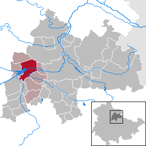
| Location of the municipality of Straussfurt in the Sömmerda district | ||
  |
||

Straussfurt is a municipality in the Sömmerda district in Thuringia and the seat of the Straußfurt administrative community , to which six other municipalities belong.
geography
Straussfurt lies on the Unstrut in the Thuringian Basin .
The districts of Henschleben and Vehra belong to Straussfurt .
climate
Straussfurt is one of the driest places in Germany. In 1911, for example, an annual rainfall of only 242 mm was measured. Straussfurt thus holds Germany's drought record.
history
Before 1800
Near Straussfurt, graves from the Younger Stone Age, the Bronze Age and the time of the Thuringian Empire were uncovered, which document an early settlement of the area.
The community was first mentioned in writing in 744 as Stuffefurte in a list of donations from Thuringia to the Fulda monastery at the time of Boniface . According to Wolfgang Kahl , it was first mentioned in the period from 780 to 802. The name, also "Strusforte", probably means a "ford lined with shrubbery" over the formerly much wider and deeper Unstrut.
In 1080 a battle between the troops of King Heinrich IV and the opposing king Rudolf von Rheinfelden took place on the meadows between Straussfurt, Vehra and Henschleben , which the latter lost. Since then this area has been called "Mordäcker". In Straussfurt there were soon several clerical landlords and a fortified knight's seat of servants of the Landgrave of Thuringia. In the 13th century a knight Eberhard von Straussfurt is mentioned, in 1387 a Conrad von Tannrode, lord of Stusforte. In the late Middle Ages, the castle was fundamentally converted into a fort-like structure with a deep and wide moat. In the German Peasants' War in 1525, 20 Straussfurt farmers joined the “Salzaer Haufen”. In 1592 a great fire raged in the village, which destroyed 74 houses. In 1597 350 Straussfurter died of the plague. In 1613 the place suffered particularly badly from floods during the " Thuringian Flood ". During the Thirty Years' War Straussfurt lost three quarters of its inhabitants.
In 1706 the von Münchhausen family acquired the five manors and the castle from the inheritance of the von Selmnitz family . In 1735, the later Hanoverian Prime Minister Gerlach Adolph von Münchhausen converted it into a castle with a large park , while retaining the outer walls . In 1724 Baroness Katherina Sophia von Münchhausen built an orphanage, from which the “Orphanage Foundation” emerged, and did a lot for the poor part of the population. In 1747 the vault in the Petrikirche was rebuilt. In 1752 there was again particularly heavy flooding through the Unstrut. Gerlach Adolph von Münchhausen, who died in 1770, was described as the "benefactor of Straussfurt".

1800 to 1945
Straussfurt belonged to the administrative office of Weißensee until 1815 . In 1815 the place became Prussian and part of the Weißensee district . From 1816 to 1840 Baron Ernst Friedrich Ferdinand von Münchhausen was his first district administrator. In 1828/33 the Kunststrasse was built from Erfurt to Kindelbrück via Straussfurt.
In 1863 a "Royal Postal Expedition" was set up. In 1867 a Landwehr association was founded. In 1869 the Nordhausen – Erfurt railway line with a train station in Straussfurt was put into operation. In 1882 the place and its surroundings were hit five times by floods. In 1890 a preservation institute for small children was opened, which the Baron Ernst von Münchhausen had donated. In 1891 there were 1,356 inhabitants in Straussfurt. In 1905 the "Jahn-Turnverein" was founded. In 1911 Straussfurt received electric light.
During the First World War in 1915/16 the castle served as a convalescent home for wounded soldiers. In 1917 the castle and manor property passed to Count Joseph Friedrich von Brühl. In 1944 the castle was certified in good condition, albeit in need of renovation.
After the French occupied the Ruhr area in 1919, the community took in 30 children from there. During the unrest in central Germany in the autumn of 1923, two communist groups formed in Straussfurt. In 1925 an agricultural training school was opened. In 1932 the gymnasium built by the Jahn-Turnverein was inaugurated. In 1933 the school and church were separated. A settlement was built from 1936 and a kindergarten was set up in the village in 1937.
Pastor Johannes Rathmann (born in 1901) was summoned to the Weissensee District Court at the beginning of 1935 for the dissemination of the Confessing Church's writings and got away with a fine.
During the Second World War there were 200 prisoners of war in Straussfurt who were used as labor. On April 10, 1945, after fighting with the Volkssturm, shelling and the destruction of the gym, goods shed and brickworks, American troops moved into Straussfurt. At the beginning of July 1945 they were replaced by Soviet units and Straussfurt became part of the Soviet zone of occupation . In the period that followed, many displaced persons were taken into the community.
From 1945
1945 took place in the context of land reform , the expropriation of the manor, the castle and the Munchausen Foundation. One third of the 620 hectares was a state-owned property (VEG), two thirds were divided up and new farms were created. Between 1945 and 1948, the castle was demolished (for the extraction of building material, but it was not suitable) and ultimately the castle was blown up. It was based on the SMAD order No. 209 for the removal of aristocratic seats. The Münchhausen Orphanage Foundation was dissolved in 1951.
In 1952 the construction of the flood retention basin Straussfurt an der Unstrut began , through which Straussfurt and the areas downstream were protected from the floods that have been occurring for centuries, which were often catastrophic. Commissioning took place in 1961, later technical improvements. The water reservoir was also used to irrigate the intensively used arable land in the area. The reservoir, which is populated by waterfowl when it is full, is not used as a local recreation area. The unstrut, which used to flow slowly in many loops, was straightened like a channel over the entire course and thus accelerated in the flow. To the south-east of Straussfurt there are still cut-off Unstrut loops used by anglers as biotopes. In the past, the Unstrut extended as far as the Straussfurt estate park, which was cleared after 1945.
The Stödten manor, expropriated in 1945 and removed in the 1950s, was located in the area of the current northwest corner of the retention basin .
Incorporations
On December 31, 2019, the community of Henschleben was incorporated into Straussfurt.
Population development
|
|
|
|
|
Data source: Thuringian State Office for Statistics
politics
Municipal council
The municipal council from Straussfurt consists of 12 councilors and councilors.
- BIST (Free Voters) 7 seats (± 0)
- CDU 5 seats (± 0)
(As of: local elections on May 25, 2014)
mayor
The honorary mayor is Olaf Starroske.
coat of arms
Blazon : "In a silver shield a blue shield base, inside two silver wavy bars, above a green willow."
Parish partnership
A partnership with Biberbach in Bavaria has existed since 1994 .
Culture and sights


- The Church of St. Petri was built between 1616 and 1620 by rebuilding an older church. In the church wall there are several erect, heavily weathered grave slabs from 1484 to 1610. In 1747 the wooden barrel vault, the "sky", was rebuilt. In 1882 the exterior of the nave and tower was restored. Closed in 1980 because of the risk of collapse, the church was consecrated again in 1987.
- A restored monument with a column and a Prussian eagle in front of the church, built in 1896, commemorates the German-Danish War (1864), the German War (1866) and the Franco-German War (1870/71).
- The memorial for the fallen soldiers of the First World War (1914/18) in the churchyard was created in 1923 by the Erfurt sculptor Hans Walther (sculptor, 1888) . The style of the group of figures with a grieving mother, children and a fallen man lying in front of them is reminiscent of Ernst Barlach .
- On June 18, 2015, a stumbling block was set in front of the building at Bahnhofstrasse 7 (formerly 5) in the presence of representatives of the city administration and the district as well as a granddaughter of Gunter Demnig's victims , to remind of Melitta Opfermann, who last lived there voluntarily.
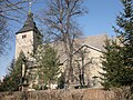
Church of St. Petri
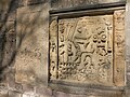
Epitaph in the church wall
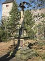
Monument 1864/66/70/71

First World War memorial


- Natural monuments
- The reservoir , located southwest of Straussfurt, functions as a retention basin for the Unstrut . The main work took place from 1952 to 1960. An idyllic Unstrut landscape was lost.
- Spring Adonisröschen slope in the "Hölzchen" area natural monument.
Economy and Infrastructure
Straussfurt was characterized by agriculture for a long time. In 1862 the manor of the barons of Münchhausen was the largest in the Weissensee district. In 1863 a "Royal Postal Expedition" was founded. In 1864 Schaper built the roof tile factory. In 1871 Robert Wagner founded a large sugar factory in Straussfurt, whose workers had their own health insurance. In 1911 Straussfurt received electric light. In 1939 the sugar factory's own power station was inaugurated. In 1946, brickworks, sugar factories and large agricultural property were expropriated and land was divided among new farmers and a state-owned estate was established. From 1952, the peasants were forced to collectivize, which was completed in 1960. VEG trained many apprentices. Agriculture was industrialized. The flood retention basin supplied the water for a large irrigation system that went into operation in 1971. In 1985 the brick factory was demolished. The VEG came under trust management in 1990, in 1993 it was converted into an "Agrarproduktions GmbH Gut Straussfurt". In 1993, an oil heating system for the sugar factory was put into operation, the 85 meter high chimney of the previous thermal power station - the landmark of Straussfurt - was removed. The sugar factory, which has belonged to Südzucker AG since 1991 , was closed in 1996 as part of the consolidation of the German sugar market and then demolished.
traffic
Straussfurt is located at the intersection of two federal highways: Federal road 4 runs in north-south direction and federal road 176 in east-west direction .
Straussfurt was a railway junction . This is where the Nordhausen – Wolkramshausen – Erfurt line that went into operation in 1869 and the Straussfurt – Großheringen (Pfefferminzbahn) line that opened five years later crossed . On June 1, 1906, the Straussfurt – Bad Tennstedt line was also opened. In 1997/98 the traffic on this route was stopped, as was the one on the peppermint railway in 2007 on the section between Straussfurt and Sömmerda.
Although Straussfurt is on the Unstrut, it is bypassed in a wide arc south of the Unstrut cycle path due to the reservoir. An unofficial path that can be used with a sporty bike leads to the left of the Unstrut from Straussfurt to Wundersleben , where it meets the signposted and asphalted Unstrut cycle path to the right of the river towards Schallenburg.
education
- State primary school in Straussfurt
- State regular school in Straussfurt
Personalities
- Gerlach Adolph von Münchhausen (1688–1770), Prime Minister in the Electorate of Hanover, founder of the University of Göttingen, builder of the Straussfurt Palace and "benefactor of Straussfurt"
- Ernst Friedrich Ferdinand von Münchhausen was the first district administrator in the Weißensee district of the Prussian government district of Erfurt from 1816 to 1840
- Ferdinand von Münchhausen (1810–1882), Upper President of the Prussian Province of Pomerania in Stettin and member of the Prussian mansion
Others
During the Second World War , more than 60 military internees from Italy as well as women and men from Poland , Ukraine and Russia had to do forced labor : in agriculture, in the sugar factory and in the railway maintenance department . Two fatalities are recorded in this context.
literature
- Friedrich B. Frhr. von Hagke : Documented news about the towns, villages and estates of the Weissensee district. Contribution to a Codex Thuringiae diplomaticus. Großmann, Weißensee 1867, ( digitized version ).
- Thomas Bienert: Fortification in Straussfurt in Boniface's time. In: Thüringer Allgemeine , 2006, (From the series: The fate of battered and extinguished noble seats. ).
- Straussfurt through the ages. Geiger, Horb am Neckar 1994, ISBN 3-89264-918-9 .
Web links
Individual evidence
- ^ Population of the municipalities from the Thuringian State Office for Statistics ( help on this ).
- ↑ Weather records on the DWD website .
- ^ Wolfgang Kahl : First mention of Thuringian towns and villages. A manual. 5th, improved and considerably enlarged edition. Rockstuhl, Bad Langensalza 2010, ISBN 978-3-86777-202-0 , p. 276.
- ↑ Thuringian Association of the Persecuted of the Nazi Regime - Association of Antifascists and Study Group of German Resistance 1933–1945 (Ed.): Local history guide to sites of resistance and persecution 1933–1945. Thuringia . tape 8 . VAS - Publishing House for Academic Writings, Frankfurt am Main 2003, ISBN 3-88864-343-0 , p. 278 .
- ↑ Thuringian Law and Ordinance Gazette No. 11/2019 of October 18, 2019, p. 385 ff. , Accessed on January 5, 2020
- ↑ Thuringian Association of the Persecuted of the Nazi Regime - Association of Antifascists and Study Group of German Resistance 1933–1945 (Ed.): Local history guide to sites of resistance and persecution 1933–1945. Volume 8: Thuringia. VAS - Verlag für Akademische Schriften, Frankfurt am Main 2003, ISBN 3-88864-343-0 , p. 278.
Alperstedt | Andisleben | Büchel | Buttstädt | Eckstedt | Elxleben | Gangloffsommern | Gebesee | Griefstedt | Großmölsen | Großneuhausen | Großrudestedt | Favored | Hatred life | Kindelbrück | Kleinmölsen | Kleinneuhausen | Kölleda | Markvippach | Nöda | Ollendorf | Eastern amondra | Rastenberg | Riethgen | Riethnordhausen | Ring life | Castle Vippach | Schwerstedt | Sömmerda | Sprötau | Straussfurt | Udestedt | Vogelsberg | Whale life | Weissensee | Werningshausen | Witterda | Miraculous life