
Ollendorf
| coat of arms | Germany map | |
|---|---|---|

|
Coordinates: 51 ° 2 ′ N , 11 ° 11 ′ E |
|
| Basic data | ||
| State : | Thuringia | |
| County : | Sömmerda | |
| Management Community : | Gramme-Vippach | |
| Height : | 212 m above sea level NHN | |
| Area : | 9.16 km 2 | |
| Residents: | 414 (Dec. 31, 2019) | |
| Population density : | 45 inhabitants per km 2 | |
| Postal code : | 99198 | |
| Area code : | 036203 | |
| License plate : | SÖM | |
| Community key : | 16 0 68 039 | |
| Association administration address: | Erfurter Str. 6 99195 Schloßvippach |
|
| Website : | ||
| Mayor : | Volker Reifarth | |
| Location of the community of Ollendorf in the district of Sömmerda | ||
  |
||

Olle village is a municipality in the Thuringian district Sömmerda and administratively part of the administrative community Gramme Vippach .
Surname
On a map of Thuringia by Gerhard Mercator, Ollendorf was still referred to in 1585 as “Oltorff”. It therefore makes sense to interpret the name as a designation for an old village.
According to Ernst Förstemann , however, it would also be conceivable that the word part “Ol” comes from the root word “Aul”, which he classifies as a personal name. If one continues to derive, like Wilfried Seibicke , the Middle German name of a potter, the Aulner, from the Middle High German word for pot “ûle”, Latin “olla”, this has quite a similarity to spelling that Ollendorf wore in the course of its history. So it is just as conceivable that the place was known in ancient times as a place where pottery was made. In addition, there are clay deposits in the vicinity to this day.
geography
The village was founded at the origin of the Rossenbach, which rises in the local area with a powerful pouring spring called the Heilsborn . Ollendorf is located halfway between Weimar and Erfurt on the western slope of the Ettersberg .
The traveler usually crosses Ollendorf if he does not take the Autobahn 4 or the federal highway 7 to travel between the two cities , but instead takes the more scenic route over the Ettersberg, where he gets to Weimar past the former Buchenwald concentration camp . Ollendorf is located at the intersection of two old trade routes: an old salt road runs from Bad Frankenhausen to Nuremberg in a north-south direction, and the Via Regia runs through the town in an east-west direction .
Ollendorf also owes its location to the fact that it is today on the Ecumenical Pilgrimage Route, which begins in Görlitz and winds along the Via Regia through Saxony , Saxony-Anhalt and Thuringia to Vacha and enables a pilgrimage to Santiago de Compostela .
history
The beginnings of settlement go back to the early Paleolithic . Ollendorf is mentioned for the first time as Ollendorf in the Codex Eberhardi of the imperial abbey of Fulda in a regest dating from 822 to 842 . The village developed from two settlement centers near the upper church "Sankt Petri" (destroyed by Swedish cavalry in 1646) and the lower church "Sankt Philippus & Jakobus". The "Lange Gasse" connects the two settlement centers to form a clustered village .
For a long time until 1518 the barely proven moated castle belonged to the Counts of Gleichen . At that time they were handed over to the von Utzberg family. In 1532 the city of Erfurt acquired it . The complex burned down in 1692 and was rebuilt as a farmyard in 1694 . Napoleon stopped in this property on October 22nd, 1813 while fleeing after the Battle of Nations. There are only a few remaining systems of the moated castle left. A last renovation with expansion of the "moated castle" took place in 1863. Today (2011) it is in a state of disrepair. Youth groups do development work. The surrounding moat is neglected. A half-timbered farm building on Dorfstrasse serves as a "culture store". With the Congress of Vienna , the place with the Amt Azmannsdorf came to the Grand Duchy of Saxony-Weimar-Eisenach ( Amt Vieselbach ), to whose administrative district Weimar it belonged from 1850.
During the Second World War , the first 21 Polish forced laborers came to Ollendorf in 1940. From 1942, 43 men and women from the Soviet Union and 28 people from the former Yugoslavia followed . In March 1944, 68 people from Ukraine , Poland , Serbia and Croatia were registered. In addition, Italian military internees from Stalag IX C Bad Sulza and from the Mohlsdorf-Teichwolframsdorf camp were deployed. The detainees had to do forced labor in agriculture. It is known that the 18-year-old slave laborer Zinaida Kalaschnikowa because of "refusal to work" the Secret State Police in Weimar was transferred and from 2 September to November 1, 1944 to "education adhesion" to the "labor education camp" Watenstedt admitted
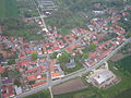
View of Ollendorf (2010)
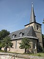
Philip and James (2011)

View of the castle and moat (2007)

Manor house (moated castle) in Ollendorf (2011)


Culture and sights
- Parish Church of St. Philip and James
- Moated castle Ollendorf
- See also: List of cultural monuments in Ollendorf
Club life
- Sports club with the sections football, popular sport and bowling
- Home and fair association
- Shooting club
- Volunteer firefighter
- Amateur playgroup
- Church building initiative
- Rural Women's Association
Events
- January - Christmas tree burning
- April 30th - May fire
- Ascension - fair
- June / July - Sports festival of SV 1927 Ollendorf
- September - village flea market
- November 10th - Lantern Parade
- December - Christmas market
Personalities
- Gustav Zunkel (1886–1934), a German politician (NSDAP), born in Ollendorf
- Thomas A. Seidel (* 1958), Protestant theologian and historian, completed his vicariate in Ollendorf from 1986 to 1988. From January 1st 1989 active as parish and district youth pastor in the parish of Ollendorf.
literature
- Otmar Ellinger, Hans-Jürgen Lange, Dr. Thomas A. Seidel, Frank Störzner and Karl-Heinz Volklandt: Ollendorf - Contributions to Local History , 2006
Individual evidence
- ^ Population of the municipalities from the Thuringian State Office for Statistics ( help on this ).
- ↑ Zoomable map from 1585
- ↑ Ernst Förstemann , Old German Name Book, Vol. 2: Place names, Nordhausen 1872, scan page 88
- ^ Wilfried Seibicke , Die Personalennamen im Deutschen, 2nd edition 2008, ISBN 978-3-11-020466-7 , scan page 172
- ↑ Thomas Bienert: Medieval castles in Thuringia. 430 castles, castle ruins and fortifications. Wartberg-Verlag, Gudensberg-Gleichen 2000, ISBN 3-86134-631-1 , p. 289.
- ↑ Wasserburg.
- ↑ Thuringian Association of the Persecuted of the Nazi Regime - Association of Antifascists and Study Group of German Resistance 1933–1945 (Ed.): Local history guide to sites of resistance and persecution 1933–1945. Volume 8: Thuringia. VAS - Verlag für Akademische Schriften, Frankfurt am Main 2003, ISBN 3-88864-343-0 , p. 272.
Web links
- thueringenfotos.de - Photos from the village from 1989
- www.ollendorf-online.de
- MDR - The place name Ollendorf
Alperstedt | Andisleben | Büchel | Buttstädt | Eckstedt | Elxleben | Gangloffsommern | Gebesee | Griefstedt | Großmölsen | Großneuhausen | Großrudestedt | Favored | Hatred life | Kindelbrück | Kleinmölsen | Kleinneuhausen | Kölleda | Markvippach | Nöda | Ollendorf | Eastern amondra | Rastenberg | Riethgen | Riethnordhausen | Ring life | Castle Vippach | Schwerstedt | Sömmerda | Sprötau | Straussfurt | Udestedt | Vogelsberg | Whale life | Weissensee | Werningshausen | Witterda | Miraculous life