
Mohlsdorf-Teichwolframsdorf
| coat of arms | Germany map | |
|---|---|---|

|
Coordinates: 50 ° 40 ′ N , 12 ° 16 ′ E |
|
| Basic data | ||
| State : | Thuringia | |
| County : | Greiz | |
| Height : | 340 m above sea level NHN | |
| Area : | 50.59 km 2 | |
| Residents: | 4734 (Dec. 31, 2019) | |
| Population density : | 94 inhabitants per km 2 | |
| Postal code : | 07987 | |
| Primaries : | 03661, 036624, 036623 | |
| License plate : | GRZ, ZR | |
| Community key : | 16 0 76 093 | |
| Rural community division: | 11 districts , 5 localities | |
| Address of the rural community administration: |
Straße der Einheit 6 07987 OT Mohlsdorf and Steinberg 1 07987 OT Teichwolframsdorf |
|
| Website : | ||
| Mayor : | Petra Pampel (IWA) | |
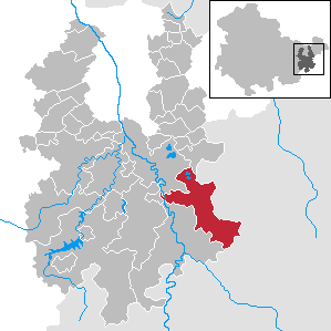
| Location of the rural community Mohlsdorf-Teichwolframsdorf in the district of Greiz | ||
  |
||

The municipality Mohlsdorf-Teichwolframsdorf is a rural municipality in the district of Greiz (Thuringia), which was created on January 1, 2012 from the merger of the municipalities Mohlsdorf and Teichwolframsdorf .
geography
Geographical location
The rural community is located in the southeast of the district of Greiz. In the east and south, the municipal boundaries also form the state border between Thuringia and Saxony. The Werzeit-Greizer forest stretches between the two main towns . According to the natural regional structure of the state of Thuringia, the municipality is counted north of the forest to the Ronneburg arable and mining area and the south to the natural area of East Thuringia Slate Mountains – Vogtland .
Neighboring communities
To the west, the city of Greiz borders on the municipality, in the northwest and northeast the city of Berga / Elster and the municipality of Seelingstädt, which is part of the Wünschendorf / Elster administrative community . In the east, the municipalities of Langenbernsdorf and Fraureuth , which belong to the district of Zwickau, and the city of Werdau border. In the southeast are the municipality of Neumark and the city of Reichenbach in Vogtland , both of which are part of the Vogtlandkreis .
Rural community division


Before its dissolution, the community of Mohlsdorf consisted of the districts Gottesgrün with Haide , Herrmannsgrün with Waldhaus , Kahmer , Mohlsdorf and Reudnitz with Eichberg and Neudeck , the community Teichwolframsdorf consisted of the districts Großkundorf , Kleinreinsdorf , Sorge-Settendorf , Teichwolframsdorf with Zaderlehde and Waltersdorf with Rüßdorf . After the merger, the two former municipalities received a local constitution and thus their own local council as well as honorary local mayors.
The municipality is located in Teichwolframsdorf.
The devastated place Katzendorf also belonged to the area of the former community Teichwolframsdorf .
history
After the councils of the municipalities of Mohlsdorf and Teichwolframsdorf had passed resolutions to dissolve the municipalities and to merge them into a rural municipality, the two mayors signed the territorial change agreement on January 13, 2011. With the merger, an application was also made to terminate the contract with the city of Berga / Elster , which has been the fulfilling municipality for both municipalities since January 1, 2008. The project was initially rejected by the interior committee of the Thuringian state parliament. After a new consultation, the state parliament approved the formation of the rural community on December 16, 2011.
Population development
|
|
Incorporations
| Former parish | date | annotation |
|---|---|---|
| God green | March 8, 1994 | Incorporation to Mohlsdorf |
| Großkundorf | March 25, 1994 | Incorporation to Teichwolframsdorf |
| Herrmannsgrün | October 1, 1922 | Incorporation to Mohlsdorf |
| Kahmer | March 8, 1994 | Incorporation to Mohlsdorf |
| Katzendorf | July 1, 1958 | Incorporation to Großkundorf; Site already devastated in 1952 due to open-cast bismuth mining |
| Kleinreinsdorf | January 1, 1997 | Incorporation to Teichwolframsdorf |
| Mohlsdorf | January 1, 2012 | |
| Reudnitz | March 8, 1994 | Incorporation to Mohlsdorf; Already from October 1, 1922 to July 31, 1924 district of Mohlsdorf |
| Sorge-Settendorf | 1st January 1974 | Incorporation to Teichwolframsdorf |
| Teichwolframsdorf | January 1, 2012 | |
| Waltersdorf | January 1, 1997 | Incorporation to Teichwolframsdorf |
Economic history
In the meanwhile devastated district of Katzendorf there was a SAG Wismut opencast mine .
politics
The municipal council was last elected on May 25, 2014, the mayor on October 6, 2013 (due to the death of Christian Häckert).
Christian Häckert ( CDU ) was the first full-time mayor of the community of Mohlsdorf-Teichwolframsdorf . When he was elected, he received around 90% of the vote with a turnout of 61.75%. Häckert was previously mayor of the dissolved community of Mohlsdorf. After Christian Häckert's death, Ms. Petra Pampel from the Interest Group for Economy and Labor (IWA) became the new mayor of the rural community in a runoff election on October 6, 2013.
The municipal council of Mohlsdorf-Teichwolframsdorf consists of 20 members. The CDU Mohlsdorf-Teichwolframsdorf provides 8 seats, the IWA 4 seats, the SPD, the citizens' initiative Teichwolframsdorf and the Left have two seats each. The free voters and the voluntary fire brigade voter community have a seat in the municipal council.
Mr. Michael Täubert (CDU) was elected 1st alderman in the first constituent meeting of the municipal council.
For the election on May 25, 2014, Michael Täubert (CDU) was also elected mayor of Mohlsdorf. Gerd Halbauer (CDU) holds the same office in Teichwolframsdorf.
Culture and sights
- One of the preserved buildings in the area of Sorge-Settendorf, which has been partially devastated by the uranium mining of SDAG Wismut, is the church, which stands in the open. From there you can see the Battle of the Nations Monument on a clear day .
- In the far west you will find the Rüßburg castle , also known as the Old Castle , Hühnerhäusel or Querfurt Castle .

The fortification located on the western high bank of the White Elster dominated a ford and was already built by the Slavs. In the late Middle Ages, the Burgplatz was re-fortified and the newly created village of Rüßdorf was added.
- In the local area of Teichwolframsdorf, Ronnenburger Straße , there was another castle complex , probably the fortified defense tower of the local founder on a hill protected by a pond. The castle site known as the Alter Schlossberg is a ground monument , of which small remains of the wall were preserved in the 19th century.
Web links
Individual evidence
- ^ Population of the municipalities from the Thuringian State Office for Statistics ( help on this ).
- ↑ StBA: Area changes from January 1st to December 31st, 2012
- ↑ Ad hoc News: Interior Committee speaks out against four parish mergers. (No longer available online.) Formerly in the original ; Retrieved October 20, 2012 . ( Page no longer available , search in web archives )
- ^ Association Reussische Fürstenstrasse Greiz: Mohlsdorf-Teichwolframsdorf. Retrieved June 4, 2017 .
- ↑ Tobias Schubert, OTZ: Christian Häckert is the new mayor in Mohlsdorf-Teichwolframsdorf. April 22, 2012, archived from the original on June 3, 2012 ; Retrieved June 4, 2017 .
- ↑ Mohlsdorf-Teichwolframsdorf community: community and local council. Retrieved June 4, 2017 .
- ↑ Michael Köhler: Thuringian castles and fortified prehistoric and early historical living spaces . Jenzig-Verlag, Jena 2001, ISBN 3-910141-43-9 , Rüßburg, p. 143 .
Auma-Weidatal | Bad Köstritz | Berga / Elster | Bethenhausen | Bocka | Brahmenau | Braunichswalde | Caaschwitz | Crimla | End contactor | Gurgling | Greiz | Grossenstein | Harth-Pöllnitz | Hartmannsdorf | Hilbersdorf | Hirschfeld | Hohenleuben | Dog heads | Crouch | Basket feet | Power Village | Kühdorf | Langenwetzendorf | Langenwolschendorf | Lederhose | Linda b. Weida | Linden Cross | Mohlsdorf-Teichwolframsdorf | Münchenbernsdorf | Paitzdorf | Pölzig | Reichstädt | Ronneburg | Rückersdorf | Saara | Schwaara | Schwarzbach | Seelingstädt | Teichwitz | Weida | Weißendorf | Wish village / Elster | Zedlitz | Zeulenroda shoot