
Linden cross
| coat of arms | Germany map | |
|---|---|---|

|
Coordinates: 50 ° 51 ' N , 11 ° 55' E |
|
| Basic data | ||
| State : | Thuringia | |
| County : | Greiz | |
| Management Community : | Münchenbernsdorf | |
| Height : | 299 m above sea level NHN | |
| Area : | 8.99 km 2 | |
| Residents: | 441 (Dec. 31, 2019) | |
| Population density : | 49 inhabitants per km 2 | |
| Postal code : | 07589 | |
| Area code : | 036604 | |
| License plate : | GRZ, ZR | |
| Community key : | 16 0 76 044 | |
| Association administration address: | Karl-Marx-Platz 13 07589 Münchenbernsdorf |
|
| Mayor : | Dirk Eigler | |
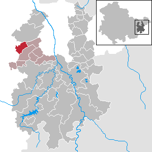
| Location of the municipality Lindenkreuz in the district of Greiz | ||
  |
||

Lindenkreuz is a municipality in the Greiz district in Thuringia . It belongs to the administrative community Münchenbernsdorf .
geography

Neighboring communities
Neighboring communities are Kraftsdorf , the city of Münchenbernsdorf and Saara in the district of Greiz and St. Gangloff and Tautendorf in the Saale-Holzland district .
Community structure
The districts Lindenkreuz, Rothenbach and Waltersdorf belong to the community .
history
Lindenkreuz , first mentioned in a document in 1487, was a grand ducal village in the district court district Weida (Electorate of Saxony, from 1815 to the Grand Duchy of Saxony-Weimar-Eisenach ( Neustädter Kreis )).
Rothenbach , a Vorwerk of the Rittergut Münchenbernsdorf , appears for the first time in a document from 1483. The place also belonged to the Weida office in the Electorate of Saxony and from 1815 to the Grand Duchy of Saxony-Weimar-Eisenach (Neustädter Kreis).
Waltersdorf , located in the Saarbachtal, is mentioned in a document from 1288. The place belonged to the "Herrschaft Gera" of the Principality of Reuss younger line .
On July 1, 1950, Lindenkreuz was incorporated into Waltersdorf together with Rothenbach. The community was renamed to Lindenkreuz on March 1, 1951. The connection to the community association Münchenbernsdorf took place in 1972.
The former school of Lindenkreuz was converted into a community room after its closure. a. is used by the volunteer fire brigade Lindenkreuz as a training room.
traffic
Lindenkreuz and Waltersdorf are on Kreisstraße 129.
RVG Regionalverkehr Gera / Land's line 200 connects the towns with Gera and Münchenbernsdorf every two hours.
Worth seeing
- Village church Lindenkreuz , built in 1744
- Schmeissersmühle with trout farm between Lindenkreuz and Waltersdorf
- the Dreiherrenstein
Linden cross

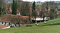
Village view

Former school

Village church


Population development
Development of the population (December 31) :
|
|
|
|
|
- Data source: Thuringian State Office for Statistics
Individual evidence
- ^ Population of the municipalities from the Thuringian State Office for Statistics ( help on this ).
Web links
Auma-Weidatal | Bad Köstritz | Berga / Elster | Bethenhausen | Bocka | Brahmenau | Braunichswalde | Caaschwitz | Crimla | End contactor | Gurgling | Greiz | Grossenstein | Harth-Pöllnitz | Hartmannsdorf | Hilbersdorf | Hirschfeld | Hohenleuben | Dog heads | Crouch | Basket feet | Power Village | Kühdorf | Langenwetzendorf | Langenwolschendorf | Lederhose | Linda b. Weida | Linden Cross | Mohlsdorf-Teichwolframsdorf | Münchenbernsdorf | Paitzdorf | Pölzig | Reichstädt | Ronneburg | Rückersdorf | Saara | Schwaara | Schwarzbach | Seelingstädt | Teichwitz | Weida | Weißendorf | Wish village / Elster | Zedlitz | Zeulenroda shoot