Brahmenau
| coat of arms | Germany map | |
|---|---|---|

|
Coordinates: 50 ° 55 ' N , 12 ° 10' E |
|
| Basic data | ||
| State : | Thuringia | |
| County : | Greiz | |
| Management Community : | At the Brahmetal | |
| Height : | 240 m above sea level NHN | |
| Area : | 6.89 km 2 | |
| Residents: | 917 (Dec. 31, 2019) | |
| Population density : | 133 inhabitants per km 2 | |
| Postal code : | 07554 | |
| Area code : | 036695 | |
| License plate : | GRZ, ZR | |
| Community key : | 16 0 76 008 | |
| LOCODE : | DE B82 | |
| Community structure: | 3 districts | |
| Address of the municipal administration: |
Brahmenau No. 41 07554 Brahmenau |
|
| Website : | ||
| Mayor : | Bernd Blume (FWG) | |
| Location of the municipality of Brahmenau in the district of Greiz | ||
Brahmenau is a municipality in the Thuringian district of Greiz .
geography
Neighboring communities
Neighboring communities are Bethenhausen , Großenstein , Hirschfeld and Schwaara in the district of Greiz and the communities of Cretzschwitz, Dorna and Söllmnitz, which were incorporated into Gera in 1994 .
Community structure
The community is divided into Brahmenau, Wüstenhain and Zschippach . Brahmenau, in turn, is formed by the merger of the then independent communities of Culm , Waaswitz and Groitschen in the 20th century .
history
On October 1, 1922 Waaswitz to Culm incorporated, on October 1, 1937 followed Groitschen . The community of Culm was finally renamed Brahmenau on November 13, 1937. After the Second World War , the districts of Wüstenhain and Zschippach were incorporated. The first documented mentions of the communities that are now part of Brahmenau date from the 12th century and go back to even older Sorbian settlements.
On July 1, 1950, the previously independent community of Zschippach was incorporated.
After the political change in 1990 , building activity began, which can be seen from the number of inhabitants, so the number of inhabitants almost doubled between 1994 and 1999.
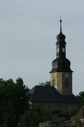
church
Population development
Development of the population (December 31) :
|
|
|
|
|
Data source: Thuringian State Office for Statistics
politics
mayor
Bernd Blume (FWG) has been mayor since 2004. He was confirmed in office on June 6, 2010 with a turnout of 69.5% with a majority of 70.7%. The previous mayor was Heidrun Reinhardt (FWG / SPD) from 1999 to 2004. Their predecessor was Roland Meinecke ( SPD ).
Municipal council
Since the local elections on May 25, 2014 , the local council has been composed as follows:
- Free voter community Brahmenau: 3 seats (39.3%)
- Brahmenau voter community: 1 seat (13.2%)
- Independent voter initiative: 1 seat (14.0%)
- Citizens' Association Yes to Brahmenau: 3 seats (33.4%)
The turnout was 67.2% (+0.9 & p).
coat of arms
Blazon : “Wavy divided by gold over red; above five black rods and below a floating half golden mill wheel. "
flag
The municipality's flag is split in yellow and red and bears the municipality's coat of arms.
traffic
Zschippach and Culm had a connection to the Gera-Meuselwitz-Wuitzer railway from 1901 to 1969 . Furthermore, the provincial road 1079 leads through Brahmenau from Bethenhausen to Gera .
The local public transport is mainly provided by RVG Regionalverkehr Gera / Land . With the 208 line, Brahmenau is connected to Gera every two hours from Monday to Sunday. Furthermore, the bus company "Herzum Tours" connects the place irregularly with Ronneburg .
people
- Max Benkwitz (* 1889 in Groitschen, † 1974 in Zeitz), German politician (SPD; USPD; KPD; SED)
Individual evidence
- ^ Population of the municipalities from the Thuringian State Office for Statistics ( help on this ).
- ↑ 2014 local elections
- ↑ Local election 2009


