Dog heads
| coat of arms | Germany map | |
|---|---|---|

|
Coordinates: 50 ° 50 ′ N , 11 ° 59 ′ E |
|
| Basic data | ||
| State : | Thuringia | |
| County : | Greiz | |
| Management Community : | Münchenbernsdorf | |
| Height : | 325 m above sea level NHN | |
| Area : | 7.89 km 2 | |
| Residents: | 317 (Dec. 31, 2019) | |
| Population density : | 40 inhabitants per km 2 | |
| Postal code : | 07557 | |
| Area code : | 0365 | |
| License plate : | GRZ, ZR | |
| Community key : | 16 0 76 033 | |
| Association administration address: | Karl-Marx-Platz 13 07589 Münchenbernsdorf |
|
| Mayoress : | Gerlinde Pätzold-Häselbarth | |
| Location of the municipality of Hundhaupten in the district of Greiz | ||
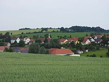
Hundhaupten is a municipality in the Greiz district in Thuringia . She is a member of the administrative association Münchenbernsdorf .
geography
Hundhaupten borders the independent city of Gera in the southeast . The community also borders on Bocka , Münchenbernsdorf , Saara and Zedlitz . The only district of Hundhaupten is Markersdorf .
history
The first known mention of the head of a dog can be found in a document from Heinrich, Vogt von Gera. In 1262 he sold his fiefs, which were held in “Hunthobit”, to the Cronschwitz monastery . In 1279 in a document from Heinrich, Vogt von Weida, Hundhaupten is called "Huntheubten". On October 1, 1922, the Russian and Weimaraner portions of the community were merged.
On July 1, 1950, the previously independent community of Markersdorf was incorporated.
Population development
The unusually sharp population decline in 2003 can be attributed to the closure of the Hundhaupten asylum seekers' home.
Development of the population (from 1994 December 31st) :
|
|
|
|
|
- Data source from 1994: Thuringian State Office for Statistics
Attractions
Individual evidence
- ^ Population of the municipalities from the Thuringian State Office for Statistics ( help on this ).


