
Basket feet
| coat of arms | Germany map | |
|---|---|---|

|
Coordinates: 50 ° 53 ' N , 12 ° 10' E |
|
| Basic data | ||
| State : | Thuringia | |
| County : | Greiz | |
| Management Community : | At the Brahmetal | |
| Height : | 291 m above sea level NHN | |
| Area : | 7.21 km 2 | |
| Residents: | 432 (Dec. 31, 2019) | |
| Population density : | 60 inhabitants per km 2 | |
| Postal code : | 07554 | |
| Area code : | 036602 | |
| License plate : | GRZ, ZR | |
| Community key : | 16 0 76 036 | |
| Address of the municipal administration: |
Local road 32 07554 Korbußen |
|
| Website : | ||
| Mayor : | Manfred Lamprecht | |
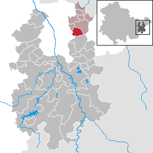
| Location of the municipality of Korbußen in the district of Greiz | ||
  |
||

Korbußen is a German municipality in the north of the Thuringian district of Greiz . She is a member of the administrative association Am Brahmetal .
geography
Geographical location
The Angerdorf Korbußen is located on a hill north of Ronneburg and east of Gera . The Großensteiner Sprat flows through the village . The municipal area is assigned to the edge of the Altenburg loess area according to the natural spatial structure of the state of Thuringia . On the southwestern edge, the municipality is flanked by the Ronneburg arable and mining area .
Neighboring communities
Neighboring communities are Großenstein , Schwaara and the city of Ronneburg in the district of Greiz and the independent city of Gera.
Community structure
Pöppeln , which is adjacent to the north and has been incorporated since 1923, has now grown together with basket feet.
history

The place was first mentioned in a document in 1301. The area was inhabited by Slavs and Germans until around 1250 . The village of Pöppeln , which was incorporated in 1923, can still be recognized as a Sorbian Rundling . Korbußen was probably founded by German settlers. In 1322 the first documented mention of the local church took place. The place was still in the year 1380 as Korwysen and in 1507 as a basket meal called. The first mention as Corbussen is known from 1619.
The history of the community has been shaped by agriculture and handicrafts up to the present day and from the 1980s by the uranium mining of SDAG Wismut . From 1991 the Korbwiesen industrial area was created .
Population development
In 1910 there were 551 inhabitants in Korbußen and Pöppeln, in 1933 there were 582 inhabitants.
Development of the population (December 31) :
|
|
|
|
|
- Data source: Thuringian State Office for Statistics
politics
mayor
In 1999, Rainer Köpler (Agrar-K) prevailed against the previous incumbent Frank Schumann (FWK) with 53.6% of the votes. The re-election took place in 2004 with 66.8% of the valid votes. In 2009 Manfred Lamprecht was elected the new mayor of the Agricultural Interest Group with 92.2%.
Municipal council
Since the local elections on May 25, 2014 , the local council has been composed as follows:
- Agricultural Interest Group - Citizens' Forum - Feuerwehrverein e. V. Basket legs: 4 seats (67.0%)
- Free voters Korbußen: 2 seats (33.0%)
The turnout was 71.9% (−8.8%)
badges and flags
Blazon : “Inclined left bar divided by red over silver; above in silver a black, uprooted willow with green leaves; including a golden hand basket in green. "
The municipality's flag is split green and yellow and bears the municipality's coat of arms.
Economy and Infrastructure
traffic
In 1996, the Gera-Leumnitz junction of federal motorway 4 was set up in the southwest of the municipality . From there and the nearby federal road 7, the district road K 113 opens up the place. The state road L 1081 runs through the east of the municipality from Ronneburg via Großenstein and Pölzig to the Saxony-Anhalt state border near Heuckewalde . The bus company Günter Herzum serves the community in local public transport via the bus route 211 Gera – Ronneburg – Reichstädt – Großbraunshain – Beiersdorf, which runs on weekdays except Saturdays. The next train station is about two kilometers away in Ronneburg, where there are regional express connections to Zwickau , Altenburg and Erfurt - Göttingen .
Established businesses
The Korbwiesen industrial area on the federal motorway 4 is an important business location for Ronneburg and the region around Gera .
Personalities
- Achim Reichardt (* 1929), GDR diplomat, Counselor in Sudan (1970–1972), Ambassador to Lebanon (1978–1981)
literature
- Lutz Seiler: Ostthüringen (an essay in German landscapes ), S. Fischer Verlag 2003, ISBN 3-10-070404-5
- Basket feet . In: August Schumann : Complete State, Post and Newspaper Lexicon of Saxony. 5th volume. Schumann, Zwickau 1818, p. 81.
Web links
Individual evidence
- ^ Population of the municipalities from the Thuringian State Office for Statistics ( help on this ).
- ^ Municipal directory Germany 1900 - Duchy of Saxony-Altenburg - District Office Ronneburg. Retrieved October 22, 2012 .
- ↑ Michael Rademacher: German administrative history from the unification of the empire in 1871 to the reunification in 1990. City and district of Gera. (Online material for the dissertation, Osnabrück 2006).
Auma-Weidatal | Bad Köstritz | Berga / Elster | Bethenhausen | Bocka | Brahmenau | Braunichswalde | Caaschwitz | Crimla | End contactor | Gurgling | Greiz | Grossenstein | Harth-Pöllnitz | Hartmannsdorf | Hilbersdorf | Hirschfeld | Hohenleuben | Dog heads | Crouch | Basket feet | Power Village | Kühdorf | Langenwetzendorf | Langenwolschendorf | Lederhose | Linda b. Weida | Linden Cross | Mohlsdorf-Teichwolframsdorf | Münchenbernsdorf | Paitzdorf | Pölzig | Reichstädt | Ronneburg | Rückersdorf | Saara | Schwaara | Schwarzbach | Seelingstädt | Teichwitz | Weida | Weißendorf | Wish village / Elster | Zedlitz | Zeulenroda shoot