Crouch
| coat of arms | Germany map | |
|---|---|---|

|
Coordinates: 50 ° 51 ' N , 12 ° 9' E |
|
| Basic data | ||
| State : | Thuringia | |
| County : | Greiz | |
| Management Community : | Wish village / Elster | |
| Height : | 285 m above sea level NHN | |
| Area : | 8.31 km 2 | |
| Residents: | 416 (Dec. 31, 2019) | |
| Population density : | 50 inhabitants per km 2 | |
| Postal code : | 07554 | |
| Area code : | 036602 | |
| License plate : | GRZ, ZR | |
| Community key : | 16 0 76 034 | |
| Community structure: | Main town, 1 district | |
| Address of the municipal administration: |
Republic Square 1 07554 Kauern |
|
| Website : | ||
| Mayoress : | Ingrid Amm | |
| Location of the municipality of Kauern in the district of Greiz | ||
Kauern is a municipality in the Thuringian district of Greiz . The place belongs to the administrative community Wünschendorf / Elster .
geography
Geographical location
Kauern is located in the Ronneburg arable and mining area between the two cities of Gera and Ronneburg . The entire eastern municipality was a mining area and has been converted into the New Ronneburg landscape . In the south of the community, the Wipse runs east-west to the White Elster near Gera-Liebschwitz . The northern border of the municipality is affected by the Gessenbach .
Neighboring communities
Neighboring communities are Hilbersdorf and Ronneburg in the district of Greiz and the independent city of Gera . Gera borders with the core city ( Kaimberg and Poris-Lengefeld ) and the districts Falka ( Otticha ) and Thränitz ( Collis ).
Community structure
The community is divided into Kauern and the district Lichtenberg . The former places Gessen and Loitzsch belong to the municipality .
history
The first documented mention of the place comes from the year 1465, when the lords of Rudenitz were enfeoffed with the manor of Kauern. Other feudal lords were three generations of the von Friesen family from 1488 onwards . They were followed by von Watzdorf , von Zehmen and von Bose , among others .
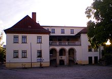
The village of Kauern belonged to the Duchy of Saxony-Altenburg and thus had a historically grown, close relationship with the nearby town of Ronneburg . The two-storey west wing of the castle dates from the 16th century and was remodeled in baroque style in 1710 by the Lords of Nauendorf ; a stuccoed field ceiling from the 16th century was preserved. The north wing was demolished in 1945. The former chapel of the castle is now a branch church of the Marienkirche Ronneburg .
Around March 25, 1945, more than 300 concentration camp prisoners were driven into the village on a death march and had to spend a week in the manor's barn. Before setting off towards Gera-Zwötzen , fellow prisoners buried several dead in the cemetery.
On July 1, 1950, the places Lichtenberg and Gessen were incorporated into Kauern. In 1958, SDAG Wismut near Lichtenberg began building the Lichtenberg opencast mine . By 1976 a hole up to 240 meters deep was created, to which Gessen and large parts of the village of Lichtenberg fell victim. After that, the uranium ore production in this open pit had to be stopped, as an expansion was impossible due to the proximity to Ronneburg and the Schmirchau mine . Until 1990, the opencast mine was partially filled with material from the surrounding shafts. By the time of the Federal Horticultural Show in 2007 it was completely refilled and integrated into the New Ronneburg Landscape .
Population development
In 1933 there were 283 residents in Kauern and 266 in 1939.
Development of the population (as of December 31st) :
|
|
|
|
|
- Data source from 1994: Thuringian State Office for Statistics
politics
Municipal council
The parish council consists of six members who are traditionally independent. Most recently, he was elected to the local elections on May 25, 2014 in a majority vote. Five of the community council members are united in the Kauern interest group. The turnout was 61.8% (+ 8.8% p).
mayor
In 1994 Matthias Spindler (UWG) prevailed in the first ballot with 71.2% of the valid votes. In 1999 he was defeated by Dietmar Scholz, who won 85.0% of the vote in the first ballot. In an early election on December 1, 2002, Jörg Bräunlich was elected mayor.
Economy and Infrastructure
Kauern is accessible via the district roads K 115 from Gera-Zwötzen to Ronneburg and K 116 from Kauern via Hilbersdorf to Pohlen . A narrow road leads to Poris-Lengefeld . The transport and operating company Gera (GVB) connects the community to the Gera tram in Zwötzen with the bus line 18 Kauern – Zwötzen – Kleinfalke – Großfalka . The next train station has been at Gera-Kaimberg in Ronneburg since the stopping point. The the air sports serving airfield Gera Leumnitz is only four kilometers away.
Web links
Individual evidence
- ^ Population of the municipalities from the Thuringian State Office for Statistics ( help on this ).
- ↑ Schlossarchiv.de
- ↑ Thuringian Association of the Persecuted of the Nazi Regime - Association of Antifascists and Study Group of German Resistance 1933-1945 (ed.): Heimatgeschichtlicher Wegweiser to places of resistance and persecution 1933-1945, series: Heimatgeschichtliche Wegweiser Volume 8 Thüringen, Erfurt 2003, p. 115 , ISBN 3-88864-343-0
- ↑ Local election results 2014


