White magpie
The White Elster ( Czech Bílý Halštrov ) is a 257 kilometer long right tributary of the Saale , of which the proportion in Germany is 245.4 kilometers.
It rises in the Czech Republic in the Elster Mountains east of Aš (Asch), about one kilometer as the crow flies from the German-Czech border (west of the border stone 5/18) near Bärendorf , not far from the village of Výhledy (Steingrün) and flows into the south of Halle 's Silberhöhe district into the hall.
The White Elster was voted "River Landscape of the Year 2020/21" by the German Fishing Association and Germany's Friends of Nature .
Surname
The name magpie has nothing to do with the bird. He belongs with its basic form Al-astra or Al-istra to Indo- el / ol for flow , flow with the Germanic ending -str . River names that go back to the same basic form can be found all over Europe (example Alster ).
For the in Adorf / Vogtl. to the White Elster opens Schwarzenbach was to the 17th century, the name Schwarze Elster used (not to be confused with the Black Elster , right tributary of the Elbe), located by the White Elster differed with their lighter dull-rich water, which as possibly naming White Magpie . The water of the Schwarzbach contains iron and is therefore darker. The White Elster does not come into contact with the Black Elster, which flows from the Lausitz into the Elbe .
In the area of the upper course of the river, the Elster Mountains were named after the White Elster. It extends over areas of the Saxon and Bohemian Vogtland. After the White Elster also has been Elster glaciation named the oldest cold period of the current ice age , when there was a large-scale glaciation in northern Germany.
geography
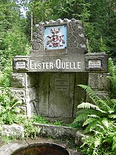
The Elsterquelle
On June 21, 1896, the Association of Vogtland Mountain Associations decided to grasp the Elster spring and to mark it with a stone and an inscription. There were actually two sources. So it was to be clarified which one should be called Elsterquelle in the future. The stone green spring was designated as this because it has the larger amount of water, is higher and follows the main direction of flow from the start.
Since October 2019, the source can be reached from Bad Brambach via the "Bärendorf Ort" stop of line 34 ( dial-a-bus with 2-hour advance notice) of the Vogtland city bus and a subsequent walk of approx. 2 km in an environmentally friendly way.
Upper and middle course
About ten kilometers after its source, the White Elster crosses the border into the Saxon Vogtland between Doubrava and Bad Elster . Behind Oelsnitz it is dammed by the Pirk dam and after the dam it flows through the towns of Weischlitz , Kürbitz and Straßberg . The White Elster then reaches the town of Plauen , then flows through the valleys of the “Vogtland Switzerland” and then leaves Saxony behind the town of Elsterberg for the time being .
Once in Thuringia , the White Elster flows through the cities of Greiz and Gera , emerging from the Vogtland low mountain range shortly before Gera and entering the red sandstone of the Saale-Elster sandstone slab . This leaves the White Elster shortly before the Saxon-Anhalt city of Zeitz and reaches the Altenburg-Zeitzer Loesshügelland and thus the North German lowlands .
Lower course
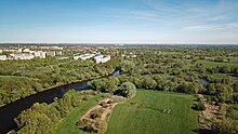
Shortly after Zeitz, the White Elster reaches the Leipzig lowland bay and widens its valley considerably (an average of two kilometers). Then it leaves Saxony-Anhalt again and flows again on Saxon territory . It passes Zwenkau and is diverted around the former opencast mine Zwenkau (today Zwenkauer See ). The White Elster then flows through Leipzig, reaches Saxony-Anhalt again at Schkeuditz and finally flows into the Saale in Halle (Saale) .
Hydromorphology
The lower course of the White Elster was shaped until the beginning of the Elster glaciation from Zwenkau by the much larger Saale , which used the valley of the White Elster in the Old Pleistocene . The Saale ran from Leipzig further north to the union with the Mulde north of Leipzig, but did not reach the Leipzig area from the Middle Pleistocene , so that now the White Elster flowed into the Mulde. Since the Saale Late Glacial , the outflow to the north has been blocked by the Taucha terminal moraine , which is why the Mulde has turned northwards from Grimma towards Wurzen and the Weisse Elster westwards towards Merseburg .
Due to the low gradient and the sediment load from the mountains, the White Elster often changed its bed from Zeitz (especially after flood events), divided into several river courses and created numerous river islands and oxbow lakes . Rivers and streams often ran for miles parallel to the White Elster in its valley until they finally flowed. However, humans began to use the fertile Elster floodplain for agriculture and to regulate the course of the river.
The White Elster has undergone the greatest changes in the past two centuries. To protect against flooding, it was heavily straightened, deepened, channeled and diked. In addition, as a result of the lignite mining in GDR times, the river bed between the Saxon cities of Zwenkau and Leipzig had to be relocated and is partly concreted and paved there. In May 2013, the discharge structure into Lake Zwenkau near Zitzschen was put into operation; it proved its worth during the floods in early June 2013 , while Leipzig was still severely affected by the floods in 1954 .
A last unobstructed section still exists between Elsteraue-Ostrau and Löbnitz-Bennewitz. Here the White Elster meanders for almost ten kilometers near the surface through many meanders with the typical interplay of erosion and sedimentation on impact and sliding slopes . Many oxbow lakes have been preserved in the floodplain of the White Elster. The term "Alte Elster" is relatively common, for example in Alte Elster (Zwenkau) and Alte Elster (Leipzig) .
Relics of the branched, anastomosing river course (often referred to as the inland delta ) are the Batschke near Zwenkau and its separate lower reaches near Leipzig (Floßgraben), the Paußnitz and the Burgauenbach , which are now artificially supplied with water. Other tributaries were the Rödel and Kuhburger Wasser , which were backfilled in the 1920s, the Hundewasser , the Rote Luppe, the Heuwegluppe, the Nördliche Alte Luppe or the Moorluppe. The confluence of the Parthe, Pleiße and Weißer Elster rivers is often referred to as the Leipzig water junction , which also includes the canalised Elster flood bed and the 155 m wide Elster basin .
In Leipzig the river divides into two larger main arms. The northern one keeps the name Weisse Elster and flows into the Saale below the Halle district of Silberhöhe . The southern arm, channeled and diked in, is the New Luppe ; at Rübsen it reunites with the White Elster. The divided the construction of the new billet billet is from Kleinliebenau been preserved as a 25 km long lower reaches of the original second main arm and now almost a pond, the east of Schkopau flows into the Saale. At the Elster weir between Döllnitz and Burgliebenau , water from the White Elster is branched off and directed to the southwest into a flood bed, which at Kollenbey merges into the original river beds of the Gerwische and the Markgraben.
Elster-Saale Canal
The Elster-Saale Canal is a canal project that was discontinued in 1943 and was intended to connect the city of Leipzig to the inland waterway network. The canal was supposed to connect the Saale with the Lindenau harbor at today's industrial area Leipzig-West, which in turn would have had a connection to the White Elster via the approximately three kilometers long Karl-Heine Canal . In 2015, the Karl Heine Canal was connected to the port, and a connection between the port and the Elster-Saale Canal is planned. It is unclear whether the remaining 8 km of the Elster-Saale Canal from Günthersdorf to the Saale will be built.
Sights and buildings
There are numerous scenic and architectural sights on the banks of the White Elster. This includes the section of the river between Plauen and Wünschendorf / Elster , where the river digs deep into the foothills of the Thuringian Slate Mountains .
Elstertal Bridge
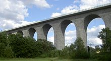
The Elstertal Bridge is part of the main railway line Leipzig / Dresden - Plauen - Hof - Nuremberg ( Saxony-Franconia Magistrale ) and runs between Jößnitz and Jocketa over the White Elster. It was built together with the nearby Göltzschtalbrücke during the construction of the Leipzig – Hof railway line on the Saxon-Bavarian Railway . The Elstertalbahn runs under the 68 m high bridge . The bridge length is 283 m. After the Göltzschtalbrücke, it is the second largest brick bridge in the world.
Elstertal bridge Pirk
The Elstertalbrücke Pirk also spans the White Elster and, as the largest ashlar arch bridge in Europe, is one of the most unusual motorway bridges in Germany. The traffic of the federal highway 72 flows over the bridge . The construction of the motorway was carried out at the end of the 1930s as part of the infrastructure program of the Nazi regime. Construction work on the bridge ceased in 1940. It was a useless silhouette of bridge arches, because only the pillars and arch stones could be erected. Later Pirk was shortly before the restricted border area of the GDR. After Pirk, the next junction to the west is already in Bavaria , so further expansion of the motorway was not necessary, as the A 72 was not a transit motorway. Coming from the east it ended in Pirk. So the building remained half finished. After the fall of the Wall, the substance was checked and it was possible to build a new, wider superstructure on the existing pillars. Since its completion, road traffic has been able to use the structure on two lanes and one hard shoulder. This put an end to the bottleneck on the A 72, when all motorway traffic had to be routed from the Großzöbern makeshift exit through the town of Pirk im Elstertal to the Plauen-Pirk junction via the federal highway 173 . There were long waiting times at the level crossing that was still in existence at the time. Today a bridge crosses the White Elster and the Plauen – Cheb railway line . This railway line also runs under the motorway bridge. Coming from the Czech Republic, the route forks in Weischlitz. On the one hand, it takes the Elstertalbahn to Greiz and Gera , and on the other to the upper train station in Plauen (Vogtland) , where it connects to the Leipzig – Hof railway line .
Old Elster Bridge
The old Elsterbrücke in Plauen was first mentioned in a document in 1244 as Pons lapideus (stone bridge). This makes it the second oldest bridge in Saxony. Two of the oldest trade routes met here and crossed the White Elster together. One street came from Nuremberg and the other from Augsburg. After the bridge they continued to Thuringia or to the east. The bridge was part of the old town fortifications of Plauen and crosses the Elster and Mühlgraben with a length of 75 meters and a width of seven meters. The bridge consists of six stone arches and used to have two towers at the ends. These tower structures were demolished at the beginning of the 19th century. In 1888 the bridge was re-consecrated after a renovation in which it was reinforced with steel struts and was given the name King Albert Bridge . On November 15, 1894, the tram line , which initially ran over the bridge on a single track, opened. From November 28, 1903, the tram ran on two tracks. In the last weeks of the Second World War, the south side of the bridge was badly damaged by a bomb. It was rebuilt after the war and renamed the Dr.-Wilhelm-Kültz- Brücke in 1949 . After road (rail) traffic had increased dramatically, a new bridge was built over the Elster in the 1970s, which was opened to traffic in November 1973. After the reconstruction in 1984, the old Elsterbrücke was only released as a pedestrian bridge. In 1986, a replica of a post mile column was erected at the southern end of the bridge, to remind of the importance of the bridge for trade. The bridge has been called the Alte Elsterbrücke since 1991. Extensive renovation work took place between 2006 and 2007 and was completed with the consecration on August 15, 2007.
Historic wooden bridge in Wünschendorf
The historic wooden bridge in Wünschendorf / Elster is one of the last surviving covered wooden bridges in Germany. It is a listed building. A first bridge was built at this point in the 13th century. After being destroyed several times, today's bridge was built in 1786.
Saale-Elster valley bridge

The Saale-Elster valley bridge is a railway bridge on the new Erfurt – Leipzig / Halle line , which spans the White Elster south of Osendorf approx. 5 km before its mouth. It was built between 2006 and 2013 and, with a total length of 8,614 m, is the longest bridge structure in Germany and the longest long-distance railway bridge in Europe . As a special feature, there is a branching on the bridge construction.
River-accompanying cycle route
Most of the cycle route runs along the shore. The nature of the path is very different, for example the asphalt part between the A 9 and Lochau is also suitable for inline skaters. In some cases the expansion is not yet complete. Over a length of around 260 kilometers, it leads from Aš through the Vogtland , over the Thuringian slate mountains to the Leipzig lowland bay and ends in Halle (Saale).
The beginning (from Aš) is characterized by mountainous sections and is therefore suitable for experienced touring cyclists. From Gera down into the valley, the route can also be used by inexperienced families and families with children. Getting here by Vogtlandbahn is particularly practical . Since the route mostly runs along the Eger-Plauen and Elstertal Railway , you are very flexible when planning the stages. The trains run every one or two hours, so that you can end the tour at any time and take the train home.
Various hiking trails run partly parallel to the bike path.
Wine route on the White Elster
The approx. 20 km long wine route between Wetterzeube and the Posa Monastery in Zeitz is counted as part of the Saale-Unstrut wine-growing region .
See also
- Old Elster (Leipzig)
- Waters in Leipzig
- Leipzig floodplain forest
- List of bodies of water in Saxony
- List of bodies of water in Saxony-Anhalt
- List of bodies of water in Thuringia
- Pleasant Wiederau , a Bach cantata in which the (White) Elster appears as a person
literature
- Winfried Schmidt: Georg Könitzer - The picturesque banks of the Elster . Hof 1993. ISBN 3-88267-045-2 .
- Klaus Grimm: The course of the White Elster . From the source to the mouth. GRIMM DRUCK and Medien GmbH, Klingenthal 2010, ISBN 978-3-933169-05-1 .
Web links
Individual evidence
- ↑ Elfriede Ulbricht: The river basin of the Thuringian Saale . 1st edition. Max Niemeyer, Halle (Saale) 1957 ( limited preview in Google book search).
- ^ A b German Hydrological Yearbook Elbe Region, Part I 2014. (PDF) State Office for Flood Protection and Water Management Saxony-Anhalt, pp. 191 & 193 , accessed on November 3, 2018 (from: lhw.sachsen-anhalt.de).
- ^ State dam administration of the Free State of Saxony / Zwickauer Mulde / Weisse Elster, September 2009
- ↑ Description of the Elsterquelle at www.echt-vogtland.de, accessed on April 13, 2011
- ↑ The White Elster will be the river landscape of the year 2020/21 , accessed on November 4, 2019
- ↑ Jürgen Udolph : Namenkundliche Studien zum Germanenproblem , p. 245, Sieboldshausen 1993, or place names as a historical source ( Memento of May 10, 2012 in the Internet Archive ) , in the Eurasischer Magazin, March 26, 2004
- ↑ Werner Pöllmann: The Rio Negro des Vogtland ( Memento from May 1, 2015 in the Internet Archive )
- ↑ Where on high pine tops , Paul Apitzsch
- ↑ Overview of all bus routes (PlusBus, TaktBus, StadtBus, BürgerBus, RufBus). (PDF) Verkehrsverbund Vogtland GmbH, November 15, 2019, p. 21 , accessed on November 18, 2019 .
- ↑ a b Lothar Eißmann : The Quaternary of the Leipzig lowland bay and adjacent areas around the Saale and Elbe . Model of a landscape development at the edge of the European continental glaciation. In: Board of the Society for Geological Sciences of the GDR (Hrsg.): Series of publications for geological sciences . Issue 2. Akademie-Verlag, Berlin 1975.
- ↑ http://www.webhobo.de/dipl.pdf (Link not available) Daniel Barnel: Laboratory tests for the investigation of hydraulic and hydrochemical processes in lignite opencast mining cliffs 1999, subsection 1.1.2 Geological overview (pdf)
- ^ Annual meeting of the German Soil Science Society ( Memento from July 29, 2015 in the Internet Archive ) Part 1 and 2, September 2, 2007 (pdf)
- ↑ Roland Fuhrmann: The development history of post-hall glacial valley sections of the White Elster and Mulde and the stratigraphic structure of the younger Quaternary . In: Altenburger Naturwissenschaftliche Forschungen , Heft 11, Altenburg / Thüringen 1999, pages 43–63 PDF .
- ↑ Leipzig Lexicon: Rivers and Lakes.


