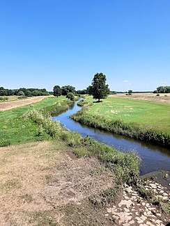
Gerwische
|
Gerwische Steinlache, still water |
||
|
The Gerwische, here as a stone pool, near Kollenbey |
||
| Data | ||
| Water code | DE : 56698 | |
| location | Germany , Saxony-Anhalt | |
| River system | Elbe | |
| Drain over | Saale → Elbe → North Sea | |
| source | as a junction of the White Elster near Döllnitz 51 ° 24 ′ 0 ″ N , 12 ° 2 ′ 2 ″ E |
|
| Source height | 82 m above sea level NN | |
| muzzle | near Halle in the Saale coordinates: 51 ° 25 ′ 56 " N , 11 ° 57 ′ 11" E 51 ° 25 ′ 56 " N , 11 ° 57 ′ 11" E |
|
| Mouth height | 80 m above sea level NN | |
| Height difference | 2 m | |
| Bottom slope | about 0.25 ‰ | |
| length | about 8.1 km | |
| Big cities | Hall | |
| Communities | Schkopau | |
The Gerwische is an approximately 8.1 kilometer long tributary of the White Elster in Saxony-Anhalt . As a common arm of the Saale and the former Elster tributary Luppe , it is a relic of the originally anastomosing river courses (often referred to as the inland delta ) and today has more of the character of a flood channel.
course
The Gerwische begins today on the Elsterwehr in the Schkopau district of Döllnitz as a stone pool. It runs roughly to the southwest in the Elster flood bed, turns to the northwest at Kollenbey and takes up the Markgraben on the left, which branches off from the Steinlache on the right after about 150 meters and flows into the White Elster.
About one kilometer after this junction and northwest of Kollenbey, the Steinlache reaches its original river bed, in which it runs as a Steinlache up to the Halle district of Planena and, continuing roughly in the direction of flow, until Beesen as Gerwische.
The last, also northwest running section with a length of about one kilometer is often called still water. It ends at the common confluence with the White Elster coming from the right into the Saale coming from the left in the south of Halle-Silberhöhe .
Original course
The Gerwische was originally the outflow of the Gessert, an old arm of the Saale in the south of Kollenbey, which was fed by a left branch of the marrow ditch (a Luppe oxbow). Only with the construction of the Elster flood bed at the beginning of the 20th century was the direct connection created with the White Elster and the marrow trench crossed.
The Gessert still drains into the Steinlache today, but has a much lower flow rate than the inlet from the White Elster.
swell
- Hydrological manual. (PDF; 115 kB) Part 2 - Area Codes. Free State of Saxony - State Office for Environment and Geology, p. 32 , accessed on December 25, 2017 .
Web links
Individual evidence
- ↑ a b measured with Google Earth
- ↑ Management plan for the FFH area "Saale-, Elster-, Luppe-Aue between Merseburg and Halle" State of Saxony-Anhalt, represented by the State Office for Environmental Protection Halle, 2011, Halle (Saale), Auf: lau.sachsen-Anhalt. de (PDF, German, 5.59 MB)
- ↑ Meilenblätter von Sachsen 1: 12000 "Berliner Exemplar", recorded 1780–1806 under the direction of Friedrich Ludwig Aster, box M 14433, sheet B2, on: deutschefotothek.de
