
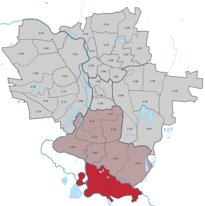
Planena
|
district of Halle (Saale) |
|
|---|---|
 _Stadtteil_4_53.svg) |
|
| Coordinates | 51 ° 24 '48 " N , 11 ° 57' 32" E |
| Residents | 36 (December 31, 2016) |
| Post Code | 06132 |
| prefix | 0345 |
| Transport links | |
| Federal road |
|
Planena is a district of the Ammendorf district in the southern district of Halle (Saale) in Saxony-Anhalt . It forms the southern border of the city to the Saalekreis. The district is largely taken up by the Saale-Elster-Aue . Planena is roughly bounded in the north and east by the White Elster and in the south and west by the Saale .
The actual town of Planena is a former small rural village in the south-west of the district.
Infrastructure and traffic
In the area of Planena there are extensive systems of the Halle-Beesen waterworks. To the northwest of the settlement is the Halle-Planena weir and a water power plant with 1.2 MW .
Planena is crossed in a north-south direction by the federal road 91 ( Halle - Merseburg - Zeitz ) and the parallel tram line Halle-Ammendorf-Bad Dürrenberg and further east by the railway line Halle-Bebra . The new Erfurt – Leipzig / Halle line with the Saale-Elster valley bridge , the longest railway bridge in Europe, runs in an east-west direction . The Planena junction on the bridge integrates the branch to Halle.
history
Planena was the property of the Faculty of Theology in Halle in Saalkreis of the Archbishopric of Magdeburg . In 1680 the place came with the Saalkreis to the Duchy of Magdeburg under Brandenburg-Prussian rule. With the Peace of Tilsit in 1807 Planena was incorporated into the Kingdom of Westphalia and assigned to the Halle district in the Saale department. The place came to the canton of Glaucha . After Napoleon's defeat and the end of the Kingdom of Westphalia, Napoleon's allied opponents liberated the Saalkreis in early October 1813. During the political reorganization after the Congress of Vienna in 1815, the place was attached to the administrative district of Merseburg in the Prussian province of Saxony and assigned to the Saalkreis.
On May 1, 1920 Planena was incorporated into Ammendorf, with whom it came to Halle (Saale) on July 1, 1950.
gallery

Junction Planena of the Saale-Elster valley bridge

Saaleschleuse, in the background the Schkopau power plant
Fish descent at the lock
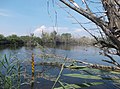
Pond next to the lock


Web links
- Halle (Saale) in figures 2016 (PDF) accessed on December 29, 2017
Individual evidence
- ^ City of Halle: Overview of the city district
- ↑ Mention of the place in the book "Geography for All Stands", p. 129.
- ^ Description of the Saale Department
- ^ The hall circle in the municipality register 1900
- ↑ Planena on gov.genealogy.net
- ↑ Halle (Saale) and its districts on gov.genealogy.net
.svg)
Old town | Ammendorf / Beesen | At the water tower / Thaerviertel | Böllberg / Wörmlitz | Büschdorf | Damaschkestrasse | Dautzsch | Diemitz | Diesel road | Dölau | Dölauer Heide | Freiimfelde / Kanenaer Weg | Happy future | Territory of the DR | Gesundbrunnen | Neustadt industrial park | Giebichenstein | Gottfried-Keller-Siedlung | Heide-Nord / Blumenau | Heide-Süd | North industrial area | Kanena / Bruckdorf | Kröllwitz | Landrain | Lettin | Lutherplatz / Thuringian Railway Station | Possible | Rivet life | Northern city center | Northern New Town | Paulusviertel | Planena | Radewell / Osendorf | Reideburg | Saale floodplain | Seeben | Silver height | South downtown | Southern New Town | Südstadt | Tornau | Trotha | Western New Town